File:Basse_Mesopotamie_DA.PNG
From Wikipedia, the free encyclopedia
No higher resolution available.
Basse_Mesopotamie_DA.PNG (440 × 393 pixels, file size: 158 KB, MIME type: image/png)
| This is a file from the Wikimedia Commons. Information from its description page there is shown below. Commons is a freely licensed media file repository. You can help. |
| DescriptionBasse Mesopotamie DA.PNG |
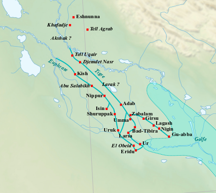
English: Map of the main cities of Lower Mesopotamia during the Early Dynastic period, with the approximate course of the rivers and the ancient shoreline of the Gulf. Français : Carte des principales villes de la Basse Mésopotamie durant la période des Dynasties Archaïques, avec le tracé approximatif des fleuves et l'ancien trait de côte du Golfe. |
| Date | (UTC) |
| Source | |
| Author |
|
| This is a retouched picture, which means that it has been digitally altered from its original version. Modifications: Ajout du tracé approximatif des fleuves et du trait de côté du Golfe, et de villes.. The original can be viewed here: Near East topographic map-blank.svg:
|
I, the copyright holder of this work, hereby publish it under the following licenses:
This file is licensed under the Creative Commons Attribution-Share Alike 3.0 Unported, 2.5 Generic, 2.0 Generic and 1.0 Generic license.
- You are free:
- to share – to copy, distribute and transmit the work
- to remix – to adapt the work
- Under the following conditions:
- attribution – You must give appropriate credit, provide a link to the license, and indicate if changes were made. You may do so in any reasonable manner, but not in any way that suggests the licensor endorses you or your use.
- share alike – If you remix, transform, or build upon the material, you must distribute your contributions under the same or compatible license as the original.

|
Permission is granted to copy, distribute and/or modify this document under the terms of the GNU Free Documentation License, Version 1.2 or any later version published by the Free Software Foundation; with no Invariant Sections, no Front-Cover Texts, and no Back-Cover Texts. A copy of the license is included in the section entitled GNU Free Documentation License.http://www.gnu.org/copyleft/fdl.htmlGFDLGNU Free Documentation Licensetruetrue |
You may select the license of your choice.
Original upload log
This image is a derivative work of the following images:
- File:Near_East_topographic_map-blank.svg licensed with Cc-by-sa-3.0,2.5,2.0,1.0, GFDL
- 2009-08-18T18:31:37Z Sémhur 2425x1581 (2442670 Bytes) 3 - New try
- 2009-08-17T15:39:22Z Sémhur 2425x1581 (1815374 Bytes) 2 - With the background...
- 2009-08-17T15:37:36Z Sémhur 2425x1581 (2836 Bytes) {{Information |Description={{en|1=Blank physical map of the [[:en:Near East|Near East]]}} {{fr|1=Carte physique vierge du [[:fr:Proche-Orient|Proche-Orient]].}} |Source={{own}} |Author=[[User:Sémhur|Sémhur]] |Date=2008-08-1
Uploaded with derivativeFX
Captions
Add a one-line explanation of what this file represents
Items portrayed in this file
depicts
image/png
d3e67d190c013ddc2af6527097fac8af152d62a5
161,888 byte
393 pixel
440 pixel
File history
Click on a date/time to view the file as it appeared at that time.
| Date/Time | Thumbnail | Dimensions | User | Comment | |
|---|---|---|---|---|---|
| current | 22:44, 17 February 2023 | | 440 × 393 (158 KB) | Zunkir | cote et cours d'eau |
| 18:20, 4 February 2018 |  | 440 × 393 (181 KB) | Zunkir | Tracé des cours d'eau, locations sites. | |
| 12:04, 28 September 2010 |  | 1,021 × 730 (817 KB) | Zunkir | {{Information |Description={{en|1=Map of the main cities of Lower Mesopotamia during the Early Dynastic period, with the approximate course of the rivers and the ancient shoreline of the Gulf.}} {{fr|1=Carte des principales villes de la Basse Mésopotamie |
File usage
The following pages on the English Wikipedia use this file (pages on other projects are not listed):
Global file usage
The following other wikis use this file:
- Usage on af.wikipedia.org
- Usage on ar.wikipedia.org
- Usage on arz.wikipedia.org
- Usage on ast.wikipedia.org
- Usage on az.wikipedia.org
- Usage on ba.wikipedia.org
- Usage on be.wikipedia.org
- Usage on ca.wikipedia.org
- Usage on cs.wikipedia.org
- Usage on cy.wikipedia.org
- Usage on de.wikipedia.org
- Usage on diq.wikipedia.org
- Usage on eo.wikipedia.org
- Usage on es.wikipedia.org
- Usage on eu.wikipedia.org
- Usage on fa.wikipedia.org
- Usage on fi.wikipedia.org
- Usage on fr.wikipedia.org
View more global usage of this file.
Retrieved from "https://en.wikipedia.org/wiki/File:Basse_Mesopotamie_DA.PNG"