File:Cold_war_europe_military_alliances_map_de.png
From Wikipedia, the free encyclopedia
Size of this preview: 582 × 599 pixels. Other resolutions: 233 × 240 pixels | 466 × 480 pixels | 746 × 768 pixels | 1,165 × 1,200 pixels.
Original file (1,165 × 1,200 pixels, file size: 419 KB, MIME type: image/png)
| This is a file from the Wikimedia Commons. Information from its description page there is shown below. Commons is a freely licensed media file repository. You can help. |
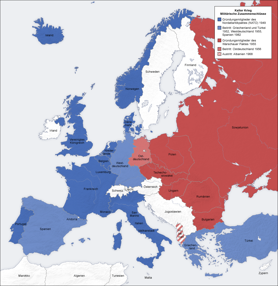
Summary
- Beschreibung: Militärische Zusammenschlüsse im Kalter Krieg, Karte de
- Quelle: eigene Karte, basierend auf den Generic Mapping Tools archive copy at the Wayback Machine und ETOPO2 archive copy at the Wayback Machine
- Autor: San Jose, 7. Oktober 2006
- Andere Version: Englisch, Französisch, Klassisches Chinesisch, ohne Text
Licensing
The map has been created with the Generic Mapping Tools: https://www.generic-mapping-tools.org/ using one or more of these public-domain datasets for the relief:
বাংলা ∙ English ∙ español ∙ français ∙ italiano ∙ 日本語 ∙ македонски ∙ sicilianu ∙ 中文(简体) ∙ 中文(繁體) ∙ +/− |

|
Permission is granted to copy, distribute and/or modify this document under the terms of the GNU Free Documentation License, Version 1.2 or any later version published by the Free Software Foundation; with no Invariant Sections, no Front-Cover Texts, and no Back-Cover Texts. A copy of the license is included in the section entitled GNU Free Documentation License.http://www.gnu.org/copyleft/fdl.htmlGFDLGNU Free Documentation Licensetruetrue |
| This file is licensed under the Creative Commons Attribution-Share Alike 3.0 Unported license. | ||
| ||
| This licensing tag was added to this file as part of the GFDL licensing update.http://creativecommons.org/licenses/by-sa/3.0/CC BY-SA 3.0Creative Commons Attribution-Share Alike 3.0truetrue |
Captions
Add a one-line explanation of what this file represents
Items portrayed in this file
depicts
image/png
4a7c3018592d951a6632c5181c323ee09128cb8e
429,167 byte
1,200 pixel
1,165 pixel
File history
Click on a date/time to view the file as it appeared at that time.
| Date/Time | Thumbnail | Dimensions | User | Comment | |
|---|---|---|---|---|---|
| current | 09:07, 12 June 2008 | | 1,165 × 1,200 (419 KB) | San Jose | update |
| 14:52, 7 October 2006 |  | 1,165 × 1,200 (470 KB) | San Jose | upload |
File usage
No pages on the English Wikipedia use this file (pages on other projects are not listed).
Global file usage
The following other wikis use this file:
- Usage on bar.wikipedia.org
- Usage on ca.wikipedia.org
- Usage on de.wikipedia.org
- Geschichte Europas
- Osteuropa
- Ostblock
- Eiserner Vorhang
- Kalter Krieg
- Benutzer:San Jose
- Wikipedia:Kartenwerkstatt/Hilfe/GMT
- Färöer im Kalten Krieg
- Liste befestigter Grenzen
- Benutzer:Sababu~dewiki/Spielwiese
- Diskussion:Geschichte Europas/Archiv
- Benutzer:Maturion/Vorlage:Ostblock
- Wikipedia Diskussion:Meinungsbilder/Verwendung des genealogischen Kreuzzeichens
- Benutzer:Maturion/Vorlagen
- Benutzer:Maturion/neu
- Polnische Volksarmee
- Benutzer:Cethegus/Geschichte Europas
- Benutzer:Coffeebattle
- November 1989
- Deutsch-sowjetische Beziehungen
- Usage on de.wikibooks.org
- Usage on es.wikipedia.org
- Usage on lb.wikipedia.org
- Usage on no.wikipedia.org
- Usage on ru.wikipedia.org