File:IVC_Map.png
From Wikipedia, the free encyclopedia
No higher resolution available.
IVC_Map.png (459 × 400 pixels, file size: 110 KB, MIME type: image/png)
| This is a file from the Wikimedia Commons. Information from its description page there is shown below. Commons is a freely licensed media file repository. You can help. |
Summary
| DescriptionIVC Map.png |
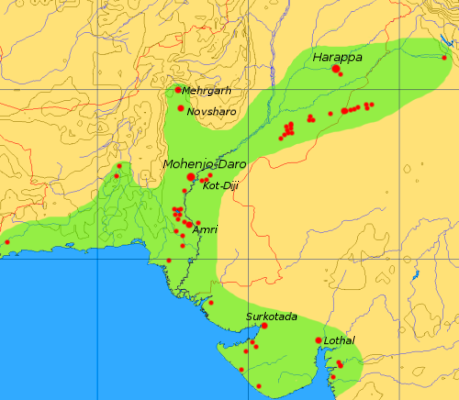
English: This map is a provisional outline of the Indus Civilization based on online sources. It is the best GFDL map we have so far, but it should be redrawn with greater accuracy and proper source attribution.
The main source of the present map is a scan of some unidentified publication, [1]. Better maps: |
| Source | Own work |
| Author | Dbachmann (talk · contribs) |
| Other versions | Image:CiviltàValleIndoMappa.png, de:Bild:Karte Harappa.png |
Licensing

|
Permission is granted to copy, distribute and/or modify this document under the terms of the GNU Free Documentation License, Version 1.2 or any later version published by the Free Software Foundation; with no Invariant Sections, no Front-Cover Texts, and no Back-Cover Texts. A copy of the license is included in the section entitled GNU Free Documentation License.http://www.gnu.org/copyleft/fdl.htmlGFDLGNU Free Documentation Licensetruetrue |
| This file is licensed under the Creative Commons Attribution-Share Alike 3.0 Unported license. | ||
| ||
| This licensing tag was added to this file as part of the GFDL licensing update.http://creativecommons.org/licenses/by-sa/3.0/CC BY-SA 3.0Creative Commons Attribution-Share Alike 3.0truetrue |
Captions
Size and major sites of the Indus Valley civilization
സിന്ധു നദീതട സംസ്കാരം
Spreiding en voornaamste sites van de Indusbeschaving (huidige staatsgrenzen in het rood)
ह्लोथल और सुतकोतदा
File history
Click on a date/time to view the file as it appeared at that time.
| Date/Time | Thumbnail | Dimensions | User | Comment | |
|---|---|---|---|---|---|
| current | 15:08, 6 September 2005 | | 459 × 400 (110 KB) | Dbachmann | update |
| 11:41, 6 September 2005 |  | 450 × 392 (102 KB) | Dbachmann | by en:User:Dbachmann {{GFDL}} see also en:Image:Indus_Map.jpg, Image:CiviltàValleIndoMappa.png |
File usage
The following pages on the English Wikipedia use this file (pages on other projects are not listed):
- 24th century BC
- History of cities
- Surkotada
- Timeline of religion
- User:Xiaopo/Scratchpad
- Wikipedia:Today's featured article/November 2004
- Wikipedia:Today's featured article/November 22, 2004
- Portal:Cities
- Portal:India/Today's selected article/May 15, 2006
- Portal:India/Today's selected article/May 2006
Global file usage
The following other wikis use this file:
- Usage on af.wikipedia.org
- Usage on anp.wikipedia.org
- Usage on ar.wikipedia.org
- Usage on arz.wikipedia.org
- Usage on ast.wikipedia.org
- Usage on bs.wikipedia.org
- Usage on ca.wikipedia.org
- Usage on cs.wikipedia.org
- Usage on cy.wikipedia.org
- Usage on de.wikipedia.org
- Usage on el.wikipedia.org
- Usage on eo.wikipedia.org
- Usage on es.wikipedia.org
- Usage on eu.wikipedia.org
- Usage on ext.wikipedia.org
- Usage on fa.wikipedia.org
- Usage on fi.wikipedia.org
- Usage on fi.wikibooks.org
- Usage on fr.wikipedia.org
- Usage on gl.wikipedia.org
- Usage on gu.wikipedia.org
- Usage on he.wikipedia.org
- Usage on hif.wikipedia.org
- Usage on hi.wikipedia.org
- Usage on hu.wikipedia.org
View more global usage of this file.
Retrieved from "https://en.wikipedia.org/wiki/File:IVC_Map.png"