File:Missouri_population_map_(2000).png
From Wikipedia, the free encyclopedia
No higher resolution available.
Missouri_population_map_(2000).png (660 × 490 pixels, file size: 33 KB, MIME type: image/png)
| This is a file from the Wikimedia Commons. Information from its description page there is shown below. Commons is a freely licensed media file repository. You can help. |
Summary
| DescriptionMissouri population map (2000).png |
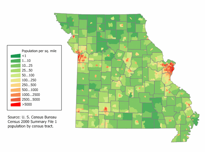
English: Missouri state population density map based on Census 2000 data. See the data lineage for a process description. |
| Date | 12 March 2006 (original upload date) |
| Source |
This file is lacking source information.
Please edit this file's description and provide a source. |
| Author | User:JimIrwin |
Licensing
JimIrwin at the English-language Wikipedia, the copyright holder of this work, hereby publishes it under the following license:

|
Permission is granted to copy, distribute and/or modify this document under the terms of the GNU Free Documentation License, Version 1.2 or any later version published by the Free Software Foundation; with no Invariant Sections, no Front-Cover Texts, and no Back-Cover Texts. A copy of the license is included in the section entitled GNU Free Documentation License.http://www.gnu.org/copyleft/fdl.htmlGFDLGNU Free Documentation Licensetruetrue |
| This file is licensed under the Creative Commons Attribution-Share Alike 3.0 Unported license. | ||
| Attribution: JimIrwin | ||
| ||
| This licensing tag was added to this file as part of the GFDL licensing update.http://creativecommons.org/licenses/by-sa/3.0/CC BY-SA 3.0Creative Commons Attribution-Share Alike 3.0truetrue |
Original upload log
Transferred from en.wikipedia to Commons using For the Common Good.
The original description page was here. All following user names refer to en.wikipedia.
| Date/Time | Dimensions | User | Comment |
|---|---|---|---|
| 12:45, 12 March 2006 | 660 × 490 (34,164 bytes) | w:en:JimIrwin (talk | contribs) | [[Category:U.S. State Population Maps]] [[Category:Missouri maps]] [[Category:United States state population maps]] [[Category:Population maps of the United States]] [[Category:Maps of Missouri]] [[Category:Population density maps of the United States]] |} [[Category:Images of maps without source]] |
Captions
Add a one-line explanation of what this file represents
Items portrayed in this file
depicts
12 March 2006
image/png
File history
Click on a date/time to view the file as it appeared at that time.
| Date/Time | Thumbnail | Dimensions | User | Comment | |
|---|---|---|---|---|---|
| current | 12:45, 21 October 2013 | | 660 × 490 (33 KB) | Fulvio314 | Transferred from en.wikipedia: see original upload log above |
File usage
The following pages on the English Wikipedia use this file (pages on other projects are not listed):
Global file usage
The following other wikis use this file:
Metadata
This file contains additional information, probably added from the digital camera or scanner used to create or digitize it.
If the file has been modified from its original state, some details may not fully reflect the modified file.
| File change date and time | 12:42, 12 March 2006 |
|---|---|
| Horizontal resolution | 37.79 dpc |
| Vertical resolution | 37.79 dpc |
.png)