File:Nelson_river_basin_map.png
From Wikipedia, the free encyclopedia
Size of this preview: 800 × 565 pixels. Other resolutions: 320 × 226 pixels | 640 × 452 pixels | 1,024 × 724 pixels | 1,200 × 848 pixels.
Original file (1,200 × 848 pixels, file size: 1.72 MB, MIME type: image/png)
| This is a file from the Wikimedia Commons. Information from its description page there is shown below. Commons is a freely licensed media file repository. You can help. |
Summary
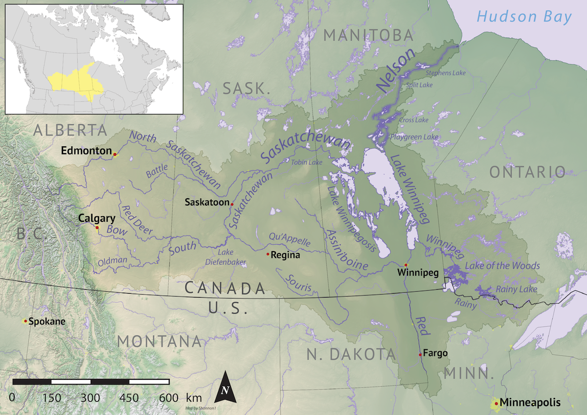
| DescriptionNelson river basin map.png |
English: Map of the Nelson River drainage basin. Data derived from NASA SRTM, Statistics Canada, US Geological Survey, Natural Earth, all public domain. |
| Date | |
| Source | Own work |
| Author | Shannon1 |
Licensing
I, the copyright holder of this work, hereby publish it under the following licenses:

|
Permission is granted to copy, distribute and/or modify this document under the terms of the GNU Free Documentation License, Version 1.2 or any later version published by the Free Software Foundation; with no Invariant Sections, no Front-Cover Texts, and no Back-Cover Texts. A copy of the license is included in the section entitled GNU Free Documentation License.http://www.gnu.org/copyleft/fdl.htmlGFDLGNU Free Documentation Licensetruetrue |
This file is licensed under the Creative Commons Attribution-Share Alike Attribution-Share Alike 4.0 International, 3.0 Unported, 2.5 Generic, 2.0 Generic and 1.0 Generic license.
- You are free:
- to share – to copy, distribute and transmit the work
- to remix – to adapt the work
- Under the following conditions:
- attribution – You must give appropriate credit, provide a link to the license, and indicate if changes were made. You may do so in any reasonable manner, but not in any way that suggests the licensor endorses you or your use.
- share alike – If you remix, transform, or build upon the material, you must distribute your contributions under the same or compatible license as the original.
You may select the license of your choice.
Captions
Add a one-line explanation of what this file represents
Items portrayed in this file
depicts
30 October 2019
image/png
File history
Click on a date/time to view the file as it appeared at that time.
| Date/Time | Thumbnail | Dimensions | User | Comment | |
|---|---|---|---|---|---|
| current | 04:41, 1 November 2019 | | 1,200 × 848 (1.72 MB) | Shannon1 | {{Information |description ={{en|1=Map of the Nelson River drainage basin. Data derived from NASA SRTM, Statistics Canada, US Geological Survey, Natural Earth, all public domain.}} |date =2019-10-30 |source =Own work |author =Shannon1 }} Category:Nelson River |
File usage
The following pages on the English Wikipedia use this file (pages on other projects are not listed):
- Armit River
- Armstrong River (Manitoba)
- Canadian canoe routes
- Etomami River
- Fir River
- Hudson Bay drainage basin
- Lake Winnipeg
- Nelson River
- Overflowing River
- Pepaw River
- Pierre Gaultier de Varennes, sieur de La Vérendrye
- Piwei River
- Rainy River (Minnesota–Ontario)
- Red Deer River (Manitoba)
- Red River of the North
- Winnipeg River
- User:Kayoty/sandbox
- User:Shannon1/Maps
Global file usage
The following other wikis use this file:
- Usage on af.wikipedia.org
- Usage on be-tarask.wikipedia.org
- Usage on be.wikipedia.org
- Usage on bg.wikipedia.org
- Usage on ca.wikipedia.org
- Usage on cs.wikipedia.org
- Usage on de.wikipedia.org
- Usage on es.wikipedia.org
- Usage on et.wikipedia.org
- Usage on fi.wikipedia.org
- Usage on fr.wikipedia.org
- Usage on hr.wikipedia.org
- Usage on hy.wikipedia.org
- Usage on it.wikipedia.org
- Usage on ja.wikipedia.org
- Usage on kn.wikipedia.org
- Usage on ko.wikipedia.org
- Usage on nl.wikipedia.org
- Usage on pl.wikipedia.org
- Usage on pl.wiktionary.org
- Usage on pt.wikipedia.org
- Usage on ro.wikipedia.org
- Usage on ru.wikipedia.org
- Usage on sh.wikipedia.org
- Usage on sr.wikipedia.org
- Usage on sv.wikipedia.org
- Usage on tr.wikipedia.org
- Usage on uk.wikipedia.org
- Usage on vi.wikipedia.org
- Usage on xmf.wikipedia.org
- Usage on zh.wikipedia.org
Metadata
This file contains additional information, probably added from the digital camera or scanner used to create or digitize it.
If the file has been modified from its original state, some details may not fully reflect the modified file.
| Software used | Adobe ImageReady |
|---|---|
| Horizontal resolution | 59.06 dpc |
| Vertical resolution | 59.06 dpc |
Retrieved from "https://en.wikipedia.org/wiki/File:Nelson_river_basin_map.png"