File:Reliefkarte_Aargau_blank.png
From Wikipedia, the free encyclopedia
Size of this preview: 630 × 600 pixels. Other resolutions: 252 × 240 pixels | 504 × 480 pixels | 807 × 768 pixels | 1,075 × 1,024 pixels | 1,965 × 1,871 pixels.
Original file (1,965 × 1,871 pixels, file size: 3.64 MB, MIME type: image/png)
| This is a file from the Wikimedia Commons. Information from its description page there is shown below. Commons is a freely licensed media file repository. You can help. |
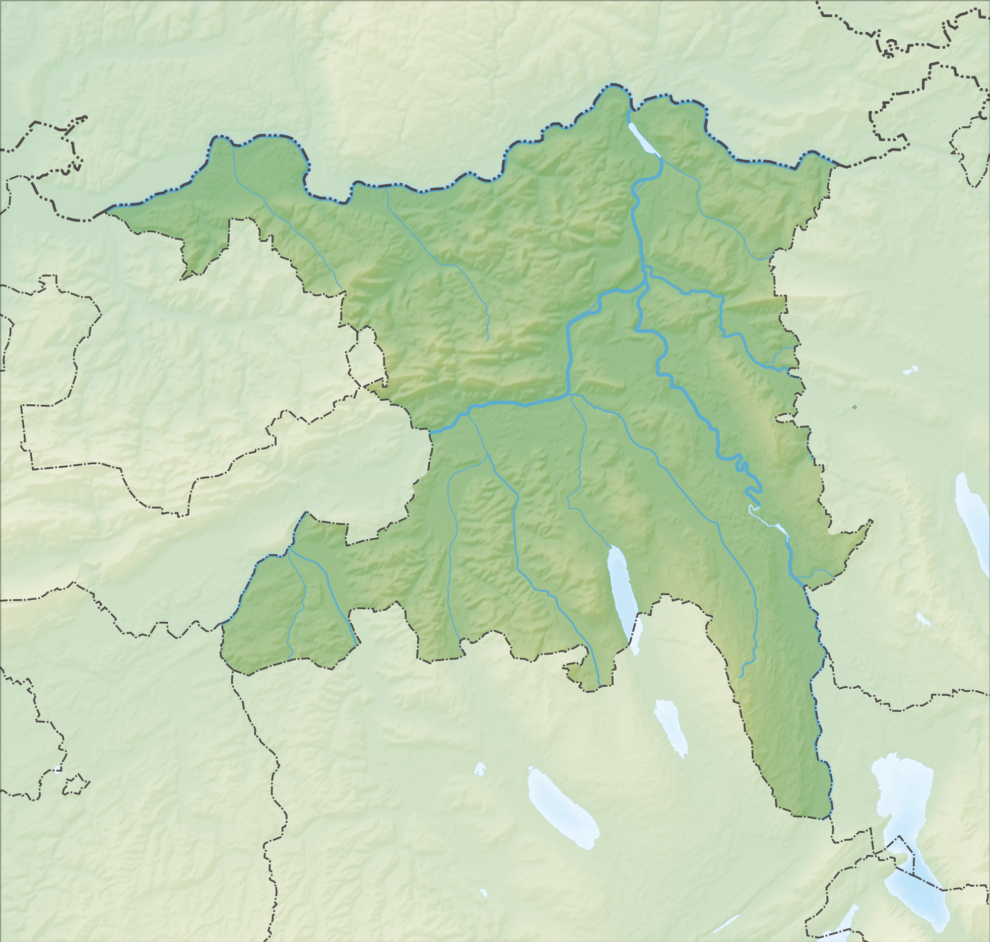
| DescriptionReliefkarte Aargau blank.png |
Deutsch: Reliefkarte des Kantons Aargau
Topographischer Hintergrund: NASA Shuttle Radar Topography Mission (public domain). SRTM3 v.2. |
||||||||
| Date | |||||||||
| Source | Own work | ||||||||
| Author | Tschubby | ||||||||
| Permission (Reusing this file) |
I, the copyright holder of this work, hereby publish it under the following licenses:
This file is licensed under the Creative Commons Attribution-Share Alike 2.5 Generic, 2.0 Generic and 1.0 Generic license.
You may select the license of your choice. |
||||||||
| Other versions |
 |

 → →  | It has been requested to crop a part of this image, so that the cropped part can serve as its own image for Laufenburg railway station.
If you perform the crop, please
العربية ∙ Deutsch ∙ English ∙ Esperanto ∙ 日本語 ∙ slovenščina ∙ македонски ∙ +/− |
Captions
Add a one-line explanation of what this file represents
Items portrayed in this file
depicts
5 December 2013
File history
Click on a date/time to view the file as it appeared at that time.
| Date/Time | Thumbnail | Dimensions | User | Comment | |
|---|---|---|---|---|---|
| current | 10:30, 5 December 2013 | | 1,965 × 1,871 (3.64 MB) | Tschubby | {{Information |Description= |Source= |Date= |Author= |Permission= |other_versions= }} |
| 10:25, 5 December 2013 |  | 1,965 × 1,871 (3.65 MB) | Tschubby | {{Information |Description= {{de| Reliefkarte des Kantons Aargau}} Topographischer Hintergrund: [http://www2.jpl.nasa.gov/srtm NASA Shuttle Radar Topography Mission] (public domain). SRTM3 v.2. |Source={{own}} |Date= 2013-12-05 |Author= [[:de:User:Tsch... |
File usage
More than 100 pages use this file. The following list shows the first 100 pages that use this file only. A full list is available.
- Aarau
- Aarburg
- Abtwil, Aargau
- Aristau
- Arni, Aargau
- Attelwil
- Auw, Aargau
- Bad Zurzach
- Beinwil (Freiamt)
- Beinwil am See
- Bellikon
- Benzenschwil
- Bergdietikon
- Berikon
- Besenbüren
- Bettwil
- Biberstein
- Birmenstorf
- Birr, Aargau
- Boswil
- Bottenwil
- Bremgarten, Aargau
- Brittnau
- Brugg
- Buchs, Aargau
- Buttwil
- Böttstein
- Bünzen, Aargau
- Densbüren
- Dietwil
- Dintikon
- Dottikon
- Ehrendingen
- Ennetbaden
- Erlinsbach, Aargau
- Fahrwangen
- Fischbach-Göslikon
- Fisibach
- Fislisbach
- Freienwil
- Full-Reuenthal
- Gallenkirch
- Gebenstorf
- Geltwil
- Gränichen
- Habsburg, Switzerland
- Habsburg Castle
- Islisberg
- Kallern
- Killwangen
- Kirchleerau
- Koblenz, Switzerland
- Kölliken
- Künten
- Laufenburg, Aargau
- Leibstadt
- Lenzburg
- Linn, Aargau
- Magden
- Mellingen
- Menziken
- Merenschwand
- Moosleerau
- Murgenthal
- Muri, Aargau
- Mägenwil
- Möhlin
- Mühlau
- Neuenhof, Aargau
- Niederrohrdorf
- Oberhof, Aargau
- Oberrohrdorf
- Oberrüti
- Oftringen
- Olsberg, Aargau
- Reitnau
- Rheinfelden (Aargau)
- Rothrist
- Rottenschwil
- Rudolfstetten-Friedlisberg
- Safenwil
- Schlossrued
- Seon, Aargau
- Sins, Aargau
- Staffelbach
- Stein, Aargau
- Strengelbach
- Uerkheim
- Uezwil
- Vordemwald
- Waltenschwil
- Wettingen
- Widen
- Wiliberg
- Windisch, Switzerland
- Würenlos
- Zofingen
- Zufikon
- Zuzgen
- User:Rich Farmbrough/notebook
View more links to this file.
Global file usage
The following other wikis use this file:
- Usage on de.wikipedia.org
- Habsburg (Burg)
- Mutschellen
- Bareggtunnel
- Kernkraftwerk Leibstadt
- Kernkraftwerk Beznau
- Bözberg (Pass)
- Lindenberg (Schweiz)
- Klingnauer Stausee
- Bözbergstrecke
- Heitersberg
- Burgruine Schenkenberg (Aargau)
- Schloss Wildenstein (Veltheim)
- Schloss Horben
- Egelsee (Aargau)
- Flachsee
- Festung Aarburg
- Staffelegg
- Schloss Liebegg
- Trostburg (Teufenthal)
- Schloss Hallwyl
- Schloss Rued
- Schloss Wildegg
- Schloss Brunegg
- Schloss Bernau (Aargau)
- Sissle
- Benkerjoch
- Böhler (Pass)
- Schloss Brestenberg
- Schloss Schafisheim
- Schloss Kasteln
- Schloss Auenstein
- Beznau
- Aarekraftwerk (Beznau)
- Geissberg (Aargau)
- Ruine Freudenau
- Schloss Biberstein
- Ruine Urgiz
- Liste von Burgen und Schlössern in der Schweiz
- Wasserflue
- Zeiher Homberg
- Ruine Königstein (Aargau)
- Ruine Horen
- Schloss Böttstein
- Murgenthaltunnel
- Rüsler
- Wikipedia Diskussion:Kartenwerkstatt
- Ägelsee
- Bahnhof Effingen
- Schloss Bellikon
- Esterliturm
View more global usage of this file.
Metadata
This file contains additional information, probably added from the digital camera or scanner used to create or digitize it.
If the file has been modified from its original state, some details may not fully reflect the modified file.
| Horizontal resolution | 118.11 dpc |
|---|---|
| Vertical resolution | 118.11 dpc |
Retrieved from "https://en.wikipedia.org/wiki/File:Reliefkarte_Aargau_blank.png"