File:Wvmapagain.png
From Wikipedia, the free encyclopedia
Size of this preview: 774 × 599 pixels. Other resolutions: 310 × 240 pixels | 620 × 480 pixels | 992 × 768 pixels | 1,280 × 991 pixels | 2,560 × 1,982 pixels | 6,587 × 5,100 pixels.
Original file (6,587 × 5,100 pixels, file size: 6.4 MB, MIME type: image/png)
| This is a file from the Wikimedia Commons. Information from its description page there is shown below. Commons is a freely licensed media file repository. You can help. |

|
This election map image could be re-created using vector graphics as an SVG file. This has several advantages; see Commons:Media for cleanup for more information. If an SVG form of this image is available, please upload it and afterwards replace this template with
{{vector version available|new image name}}.
It is recommended to name the SVG file “Wvmapagain.svg”—then the template Vector version available (or Vva) does not need the new image name parameter. |
Summary
| DescriptionWvmapagain.png |
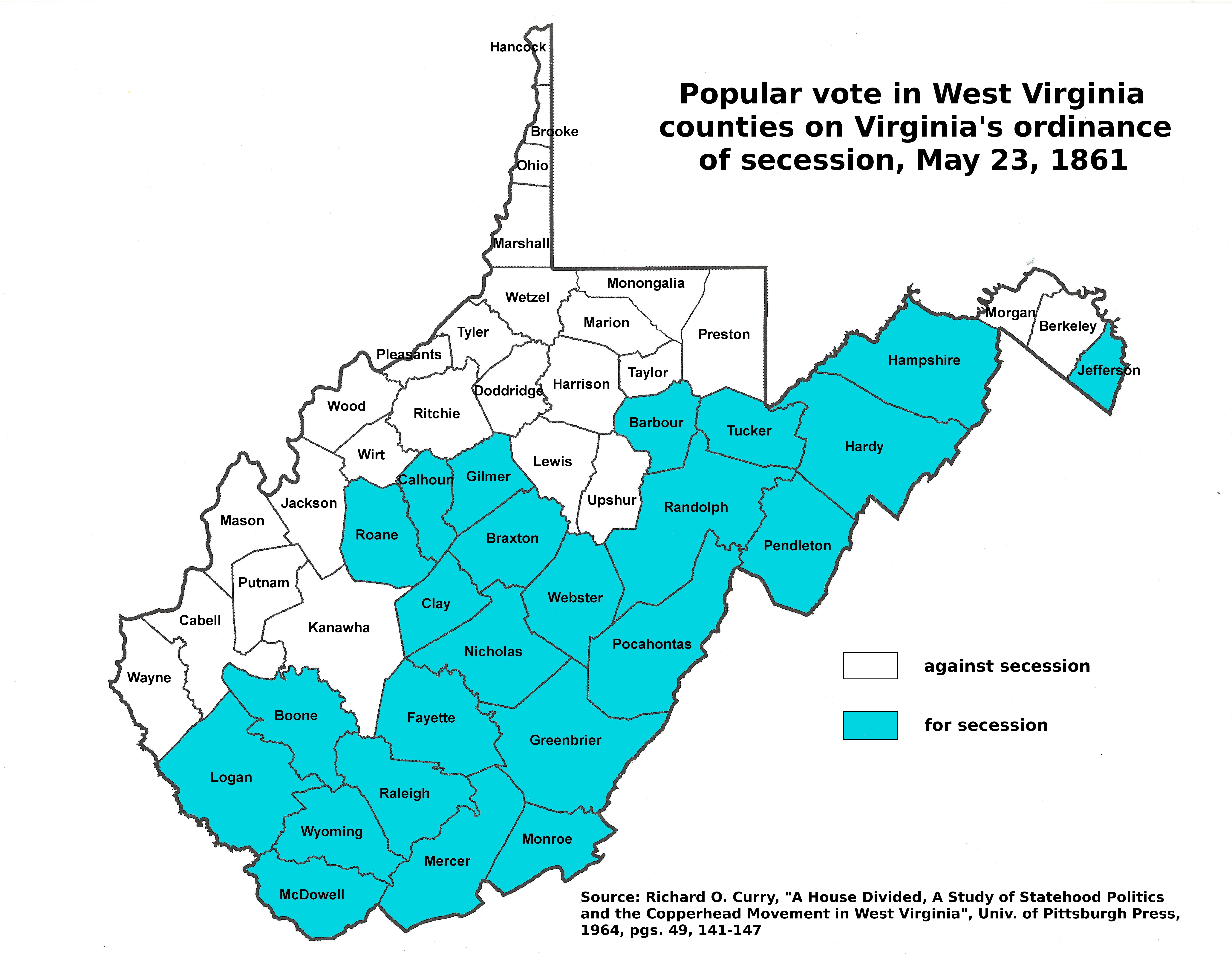
English: West Virginia Counties which ratified the Virginia ordinance of Secession on May 23, 1861. |
|||
| Date | 05/30/08 | |||
| Source | Data from Image:Wvmapagain.png by Dubyavee, with county shapes derived from Image:Map_of_West_Virginia_highlighting_Monongalia_County.svg | |||
| Author | User:brianski cleaned up Dubyavee's earlier version | |||
| Permission (Reusing this file) |
|
Licensing
| Public domainPublic domainfalsefalse |
| I, the copyright holder of this work, release this work into the public domain. This applies worldwide. In some countries this may not be legally possible; if so: I grant anyone the right to use this work for any purpose, without any conditions, unless such conditions are required by law. |
Captions
Add a one-line explanation of what this file represents
Items portrayed in this file
depicts
File history
Click on a date/time to view the file as it appeared at that time.
| Date/Time | Thumbnail | Dimensions | User | Comment | |
|---|---|---|---|---|---|
| current | 07:07, 30 November 2016 | | 6,587 × 5,100 (6.4 MB) | Dubyavee | updated map with source and county names |
| 03:32, 31 May 2008 |  | 2,136 × 1,906 (342 KB) | Brianski | thumbnailable | |
| 03:28, 31 May 2008 |  | 4,270 × 3,810 (553 KB) | Brianski | {{Information |Description={{en|1=West Virginia Counties which ratified the Virginia ordinance of Secession on May 23, 1861.}} |Source=Data from Image:Wvmapagain.png by Dubyavee, with county shapes derived from [[:Image:Map_of_West_ |
File usage
The following pages on the English Wikipedia use this file (pages on other projects are not listed):
Global file usage
The following other wikis use this file:
- Usage on ja.wikipedia.org
- Usage on ru.wikipedia.org
Metadata
This file contains additional information, probably added from the digital camera or scanner used to create or digitize it.
If the file has been modified from its original state, some details may not fully reflect the modified file.
| Horizontal resolution | 236.22 dpc |
|---|---|
| Vertical resolution | 236.22 dpc |
| File change date and time | 07:05, 30 November 2016 |
Retrieved from "https://en.wikipedia.org/wiki/File:Wvmapagain.png"