चित्र:Outre-mer_en_sans_Terre_Adelie.png
From Wikipedia, the free encyclopedia
इस पूर्वावलोकन का आकार: 800 × 342 पिक्सेल। दूसरे रेसोल्यूशन्स: 320 × 137 पिक्सेल | 640 × 273 पिक्सेल | 1,456 × 622 पिक्सेल।
मूल चित्र ((1,456 × 622 पिक्सेल, फ़ाइल का आकार: 49 KB, MIME प्रकार: image/png))
|
|
यह फ़ाइल विकिमेडिया कॉमन्स से है। वहाँ पर इसका विवरण पृष्ठ निम्नोक्त है। कॉमन्स मुक्त लाइसेंसों के अंतर्गत उपलब्ध मीडिया फ़ाइलों का संग्रह है। आप भी इसमें मदद कर सकते हैं। |
सारांश

|
This locator map image could be re-created using vector graphics as an SVG file. This has several advantages; see Commons:Media for cleanup for more information. If an SVG form of this image is available, please upload it and afterwards replace this template with
{{vector version available|new image name}}.
It is recommended to name the SVG file “Outre-mer en sans Terre Adelie.svg”—then the template Vector version available (or Vva) does not need the new image name parameter. |
| विवरणOutre-mer en sans Terre Adelie.png |
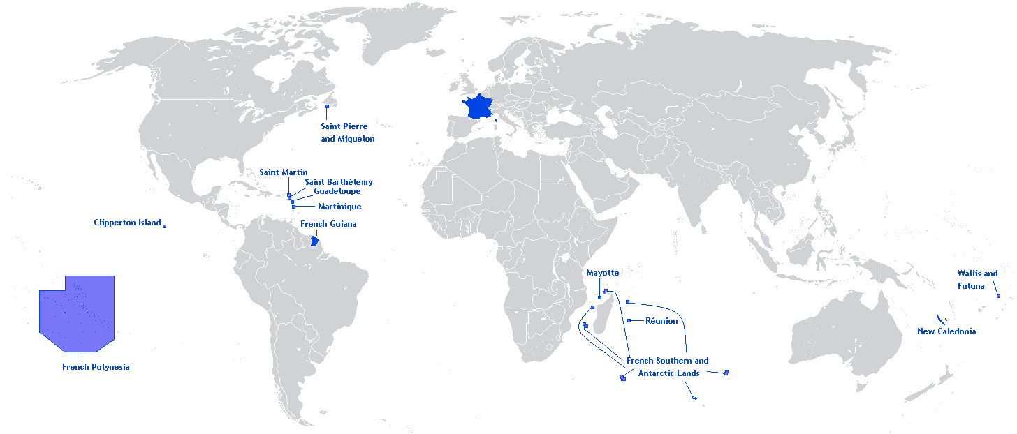
English: A map showing the Overseas departments and territories of France, excluding the territory of Adélie Land in Antarctica, where sovereignty is suspended |
| दिनांक | |
| स्रोत | अपना कार्य |
| लेखक | Originally Hoshie |
| दूसरे संस्करण | Adapted from File:Outre-mer en.png |
English: This image is a cropped version of Image:Outre-mer en.png initally created by user Hoshie. Antarctica was cropped.
लाइसेंस
Hoshie, इस कार्य के कॉपीराइट धारक, इसे निम्न लाइसेंस के अंतर्गत प्रकाशित करते हैं:

|
इस दस्तावेज़ को Free Software Foundation द्वारा प्रकाशित GNU मुक्त प्रलेख लाइसेंस के संस्करण 1.2 या नए (बिना किसी अपरिवर्तनीय अनुभागों और अगले या पिछले आवरण के टेक्स्ट के) के अंतर्गत प्रतिलिपि बनाने, बाँटने और/या बदलने की अनुमति प्रदान की जाती है। इस लाइसेंस की एक प्रतिलिपि GNU मुक्त प्रलेख लाइसेंस नामक अनुभाग में शामिल है।http://www.gnu.org/copyleft/fdl.htmlGFDLGNU Free Documentation Licensetruetrue |
| इस फ़ाइल को क्रिएटिव कॉमन्स श्रेय-समानसांझा 3.0 अनरिपोर्टेड लाइसेंस के अंतर्गत लाइसेंस किया गया है। | ||
| श्रेय: Hoshie | ||
| ||
| This licensing tag was added to this file as part of the GFDL licensing update.http://creativecommons.org/licenses/by-sa/3.0/CC BY-SA 3.0Creative Commons Attribution-Share Alike 3.0truetrue |
Captions
Add a one-line explanation of what this file represents
Items portrayed in this file
चित्रण
२७ मई 2012
source of file अंग्रेज़ी
original creation by uploader अंग्रेज़ी
चित्र का इतिहास
फ़ाइलका पुराना अवतरण देखने के लिये दिनांक/समय पर क्लिक करें।
| दिनांक/समय | थंबनेल | आकार | सदस्य | प्रतिक्रिया | |
|---|---|---|---|---|---|
| वर्तमान | 20:26, 27 मार्च 2018 | | 1,456 × 622 (49 KB) | Maphobbyist | Upload |
| 12:01, 27 मई 2012 |  | 1,456 × 622 (59 KB) | Hazhk | Changing color | |
| 20:47, 12 फ़रवरी 2012 |  | 1,480 × 625 (68 KB) | Spesh531 | same as File:Outre-mer en.png, without Antarctica | |
| 00:35, 21 अक्टूबर 2010 |  | 1,431 × 655 (54 KB) | Rosss | Better view of French Polynesia | |
| 21:23, 25 नवम्बर 2009 |  | 1,431 × 655 (30 KB) | The Illusional Ministry | removed borer from french polynesia | |
| 21:22, 25 नवम्बर 2009 |  | 1,431 × 655 (30 KB) | The Illusional Ministry | ||
| 03:31, 17 दिसम्बर 2007 |  | 1,431 × 655 (35 KB) | Rosss | Wider margin | |
| 03:26, 17 दिसम्बर 2007 |  | 1,431 × 639 (35 KB) | Rosss | This image is a cropped version of Image:Outre-mer en.png initally created by user Hoshie. Antartica was cropped. ==License== {{GFDL-user|Hoshie}} Category:World maps of Overseas France |
चित्र का उपयोग
निम्नलिखित पन्ने इस चित्र से जुडते हैं :
चित्र का वैश्विक उपयोग
इस चित्र का उपयोग इन दूसरे विकियों में किया जाता है:
- an.wikipedia.org पर उपयोग
- awa.wikipedia.org पर उपयोग
- bn.wikibooks.org पर उपयोग
- ckb.wikipedia.org पर उपयोग
- da.wikipedia.org पर उपयोग
- dv.wikipedia.org पर उपयोग
- en.wikipedia.org पर उपयोग
- Regions of France
- Outline of France
- Wikipedia:Graphics Lab/Map workshop/Archive/Dec 2009
- Wikipedia:Graphics Lab/Map workshop/Archive/Jun 2012
- User:SkulkingMEDIA
- User:Andreapr94/sandbox/Infobox/Country
- User:Jonperez91/sandbox/Infoboxes/Country
- User:Ane San José/sandbox/Infobox/Country
- User:P.aurrecoechea/Sandbox/Infobox/Country
- User:Trizia9/sandbox/Infobox/Country
- User:Ibonarzua/sandbox/Infobox/Country
- User:Mikel M/sandbox/Infobox/Country
- en.wikibooks.org पर उपयोग
- es.wikipedia.org पर उपयोग
- et.wikipedia.org पर उपयोग
- eu.wikipedia.org पर उपयोग
- fa.wikipedia.org पर उपयोग
- fr.wikipedia.org पर उपयोग
- hy.wikipedia.org पर उपयोग
- id.wikipedia.org पर उपयोग
- id.wikibooks.org पर उपयोग
- ilo.wikipedia.org पर उपयोग
- ja.wikipedia.org पर उपयोग
- lv.wikipedia.org पर उपयोग
- mai.wikipedia.org पर उपयोग
- min.wikipedia.org पर उपयोग
- ml.wikipedia.org पर उपयोग
- mzn.wikipedia.org पर उपयोग
- ne.wikipedia.org पर उपयोग
- nl.wikipedia.org पर उपयोग
- no.wikipedia.org पर उपयोग
- pa.wikipedia.org पर उपयोग
- pcd.wikipedia.org पर उपयोग
- pdc.wikipedia.org पर उपयोग
- pt.wikipedia.org पर उपयोग
- sah.wikipedia.org पर उपयोग
- sh.wikipedia.org पर उपयोग
- sr.wikinews.org पर उपयोग
इस चित्र के वैश्विक उपयोग की अधिक जानकारी देखें।
मेटाडेटा
इस फ़ाइल में अतिरिक्त जानकारी मौजूद है, जो शायद इसे बनाने या डिजिटाइज़ करने के लिए उपयुक्त डिजिटल कैमरा या फिर स्कैनर द्वारा जोड़ा गया हो।
अगर चित्र को इसके मूल रूप से बदला गया है, शायद कुछ जानकारी इसके वर्तमान स्थिति से संबंधित न हो।
| क्षैतिज रेसोल्यूशन | 37.8 dpc |
|---|---|
| वर्टिकल रिज़ोल्यूशन | 37.8 dpc |