File:Europe_1867_map_en.png
ウィキペディア フリーな encyclopedia
このプレビューのサイズ: 800 × 526 ピクセル。 その他の解像度: 320 × 211 ピクセル | 640 × 421 ピクセル | 1,024 × 674 ピクセル | 1,280 × 842 ピクセル | 2,284 × 1,503 ピクセル。
元のファイル (2,284 × 1,503 ピクセル、ファイルサイズ: 1.07メガバイト、MIME タイプ: image/png)
ウィキメディア・コモンズのファイルページにある説明を、以下に表示します。
|
概要
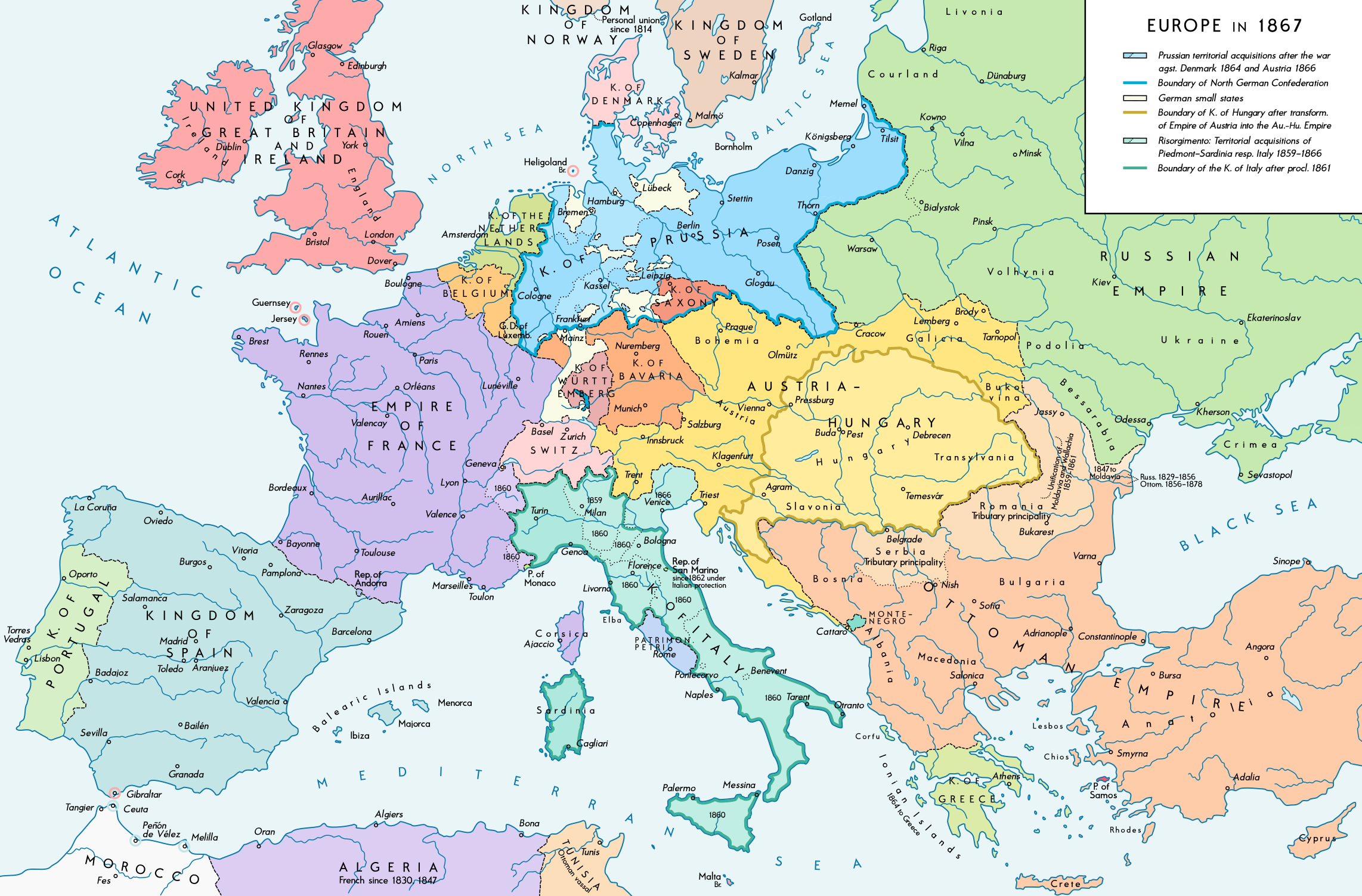
| 解説Europe 1867 map en.png |
English: Europe 1867. Historical map of the political situation after the forming of the North German Confederation, the Italian Risorgimento (with the exception of the Roman part of the Papal States) and the Austro-Hungarian Compromise of 1867. Please don't alter the map, when you think there something not written or depicted correctly. Leave a message at the talk page of the file. After a verificiation and a possible discussion, i will upload a new map version with all new changes. This prevents an unnecessary waste of disc space and ensures a good result, aesthetically and contentwise. - The author. Deutsch: Europa 1867. Historische Karte der politischen Situation in Europa nach der Gründung des Norddeutschen Bundes, des italienischen Risorgimento (mit Ausnahme des röm. Teils des Kirchenstaats) und dem Österreichisch-Ungarischen Ausgleich von 1867. Bitte die Karte bei Änderungs- und Korrekturwünschen nicht selbst verändern, sondern eine Anmerkung im Diskussionsbereich der Bilddatei hinterlassen. Nach einer Prüfung und ggfs. Diskussion werden evtl. Änderungen von mir zusammengefasst eingearbeitet. Das vermeidet unnötige Speicherplatz-Verschwendung und gewährleistet ein ästhetisch ansprechendes und inhaltlich korrektes Ergebnis. - Der Urheber. |
| 日付 | |
| 原典 |
投稿者自身による著作物. Source of Information: Historical atlases and maps – Ramsay Muir, George Philip (ed.): Philip's New School Atlas of Universal History, George Philip & Son, Ltd., London 1928 – Dr. Walter Leisering (ed.): Putzger Historischer Weltatlas, Cornelsen Verlag, Berlin 1992, ISBN 3-464-00176-8 – Bayerischer Schulbuch-Verlag (ed.): Großer Historischer Weltatlas, Dritter Teil, Neuzeit, Bayerischer Schulbuch-Verlag, München 1981, ISBN 3-7627-6021-7. – Prof. Dr. Vadim Oswalt u. Prof. Dr. Hans Ulrich Rudolf (ed.): Klett-Perthes Atlas zur Weltgeschichte, Ernst Klett Verlag, Stuttgart 2011, ISBN 978-3-12-828194-0 – Ziegelbrenner: Karte des Norddeutschen Bundes 1866–1871, 6 June 2014 version (map link) Other publications – Francesco Traniello u. Gianni Sofri: Der lange Weg zur Nation. Das italienische Risorgimento, Verlag W. Kohlhammer, Stuttgart 2012, ISBN 978-3-17-021898-7 |
| 作者 | Alexander Altenhof |
| その他のバージョン |
|

Recompressed without quality loss with OptiPNG (1.35 MB > 1.06 MB)
ライセンス
この作品の著作権者である私は、この作品を以下のライセンスで提供します。
このファイルはクリエイティブ・コモンズ 表示-継承 4.0 国際ライセンスのもとに利用を許諾されています。
- あなたは以下の条件に従う場合に限り、自由に
- 共有 – 本作品を複製、頒布、展示、実演できます。
- 再構成 – 二次的著作物を作成できます。
- あなたの従うべき条件は以下の通りです。
- 表示 – あなたは適切なクレジットを表示し、ライセンスへのリンクを提供し、変更があったらその旨を示さなければなりません。これらは合理的であればどのような方法で行っても構いませんが、許諾者があなたやあなたの利用行為を支持していると示唆するような方法は除きます。
- 継承 – もしあなたがこの作品をリミックスしたり、改変したり、加工した場合には、あなたはあなたの貢献部分を元の作品とこれと同一または互換性があるライセンスの下に頒布しなければなりません。
キャプション
このファイルの内容を1行で記述してください
このファイルに描写されている項目
題材
ウィキデータ項目がない値
4 9 2016
ファイルの履歴
過去の版のファイルを表示するには、その版の日時をクリックしてください。
| 日付と時刻 | サムネイル | 寸法 | 利用者 | コメント | |
|---|---|---|---|---|---|
| 現在の版 | 2017年4月14日 (金) 23:42 | | 2,284 × 1,503 (1.07メガバイト) | KaterBegemot | Empire of France (not Kingdom), changed main caption to "Europe in 1867", fixed font size of "Piedmont-Sardinia", minor changes |
| 2016年9月4日 (日) 21:36 |  | 2,284 × 1,503 (1.06メガバイト) | KaterBegemot | {{Information |Description ={{en|1=Europe 1867. Historical map of the political situation after the forming of the North German Confederation, the Italian Risorgimento (with the exception of the Roman part of the Papal States) and the Austro-Hungari... |
ファイルの使用状況
このファイルを使用しているページはありません。
グローバルなファイル使用状況
以下に挙げる他のウィキがこの画像を使っています:
- ast.wikipedia.org での使用状況
- en.wikipedia.org での使用状況
- et.wikipedia.org での使用状況
- it.wikipedia.org での使用状況
メタデータ
このファイルには、追加情報があります (おそらく、作成やデジタル化する際に使用したデジタルカメラやスキャナーが追加したものです)。
このファイルが元の状態から変更されている場合、修正されたファイルを完全に反映していない項目がある場合があります。
| 水平方向の解像度 | 70dpi |
|---|---|
| 垂直方向の解像度 | 70dpi |
| 色空間情報 | その他 |
| 実効画像の幅 | 2,284 ピクセル |
| 実効画像の高さ | 1,503 ピクセル |
| 使用ソフトウェア名 | Adobe Photoshop CC 2017 (Windows) |
| デジタルデータの作成日時 | 2017年4月15日 (土) 03:05 |
| ファイル変更日時 | 2017年4月15日 (土) 03:22 |
| メタデータの最終更新日 | 2017年4月15日 (土) 03:22 |
| 元文書の一意なID | xmp.did:fd41fa5f-5199-fd40-bec6-d1a7668cc651 |