File:Iss047e099713_lrg_Manila.jpg
维基百科,自由的 encyclopedia
原始文件 (4,928 × 3,280像素,文件大小:5.17 MB,MIME类型:image/jpeg)
摘要
| 描述Iss047e099713 lrg Manila.jpg |
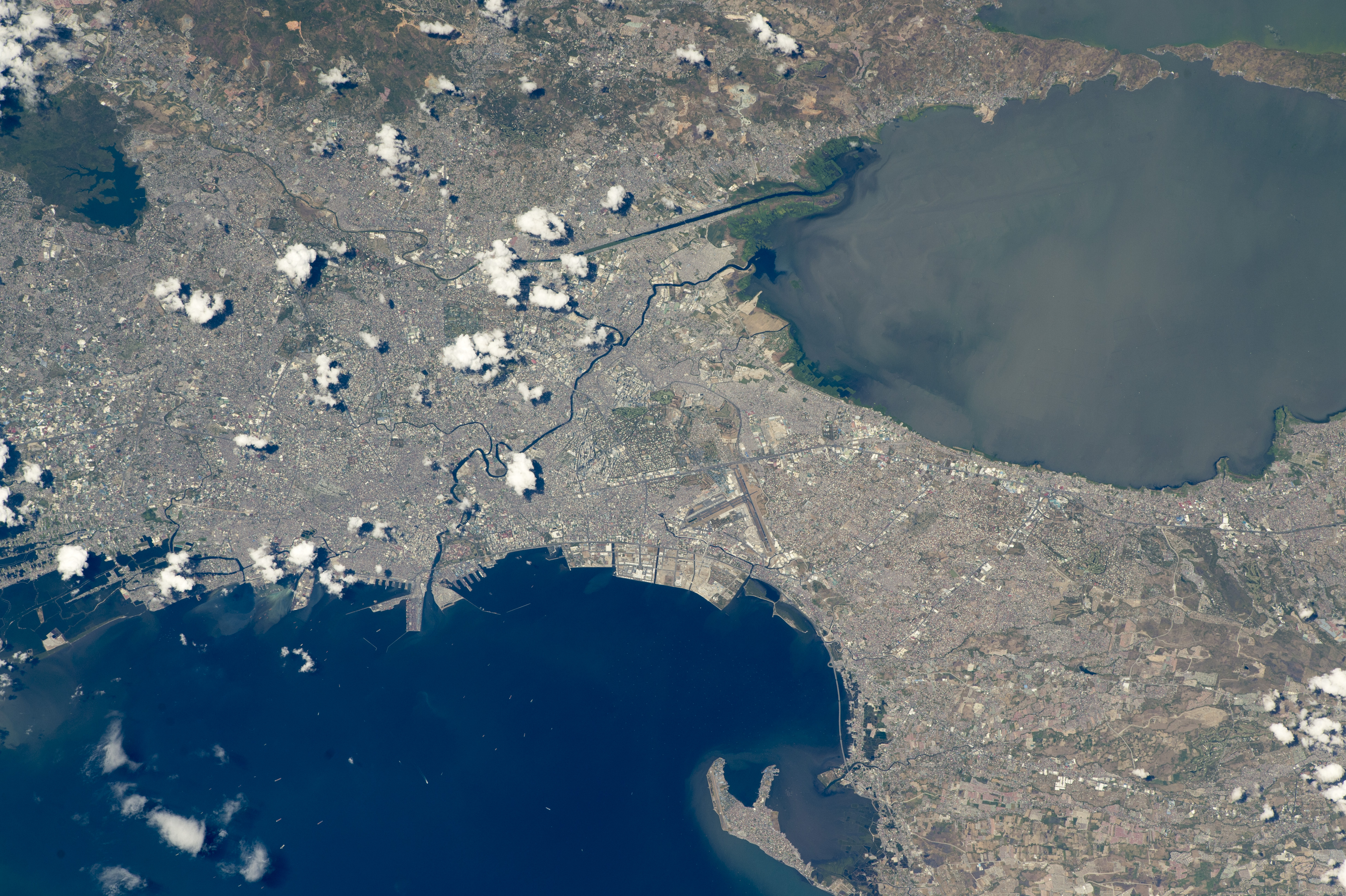
English: While orbiting over the South China Sea, an astronaut aboard the International Space Station (ISS) took this oblique photograph of the blocky red and gray urban pattern of Manila and surrounding cities. Manila is sandwiched between the salt water of Manila Bay—with its scatter of anchored ships—and Laguna de Bay. The great docks at the port can be seen jutting into Manila Bay (image center left), while the heart of the city lies immediately inland of the port. A forested nature reserve with a lake is located within one of the mountainous areas surrounding the metro zone (top left).
The combined population of Manila and neighboring Quezon City is 4.7 million people. Manila itself has one of the highest population densities in the world, with 42,857 people per square kilometer. The metropolitan area is the political and economic hub of the Philippines, and its international trade connections are so widespread the Globalization and World Cities Research Network classed Manila as a global city. Manila’s history has always been connected to trade. Arriving from Mexico, the conquistadors founded Manila in 1571, and soon the city became the Far East anchor of the Acapulco-Manila Galleon trade route connecting Spanish America with Asia. This represents one of the earliest examples of globalization. The dark lines of several waterways are prominent amidst the gray cityscape. The Pasig River winds through the middle of the city. The straight line of the Manggahan Floodway is a flood-control channel engineered to divert water from the Marikina River away from the city center and into Laguna de Bay. Engineering works along the floodway also control tidal saltwater flow into Laguna de Bay. Astronaut photograph ISS047-E-99713 was acquired on May 6, 2016, with a Nikon D4 digital camera using a 400 millimeter lens, and is provided by the ISS Crew Earth Observations Facility and the Earth Science and Remote Sensing Unit, Johnson Space Center. The image was taken by a member of the Expedition 47 crew. The image has been cropped and enhanced to improve contrast, and lens artifacts have been removed. The International Space Station Program supports the laboratory as part of the ISS National Lab to help astronauts take pictures of Earth that will be of the greatest value to scientists and the public, and to make those images freely available on the Internet. Additional images taken by astronauts and cosmonauts can be viewed at the NASA/JSC Gateway to Astronaut Photography of Earth. Caption by M. Justin Wilkinson, Texas State University, Jacobs Contract at NASA-JSC. |
||
| 日期 | |||
| 来源 | http://earthobservatory.nasa.gov/IOTD/view.php?id=88643 | ||
| 作者 | Astronaut photograph ISS047-E-99713 was acquired on May 6, 2016, with a Nikon D4 digital camera using a 400 millimeter lens, and is provided by the ISS Crew Earth Observations Facility and the Earth Science and Remote Sensing Unit, Johnson Space Center. | ||
| 其他版本 |
|
.jpg)
.jpg)
.jpg)
| 相机位置 | 14° 35′ 00″ 北, 121° 00′ 00″ 东 | 在以下服务上查看本图像和附近其他图像: OpenStreetMap |
|---|
许可协议
| Public domainPublic domainfalsefalse |
| 本文件完全由NASA创作,在美国属于公有领域。根据NASA的版权方针,NASA的材料除非另有声明否则不受版权保护。(参见Template:PD-USGov/zh、NASA版权方针页面或JPL图片使用方针。) | ||
 |
警告:
|
说明
此文件中描述的项目
描绘内容
6 5 2016
视角坐标 简体中文(已转写)
15°N, 121°E
曝光时间 简体中文(已转写)
0.00125 秒
焦距比数 简体中文(已转写)
11
焦距 简体中文(已转写)
400 毫米
ISO速度 简体中文(已转写)
200
媒体类型 简体中文(已转写)
image/jpeg
文件历史
点击某个日期/时间查看对应时刻的文件。
| 日期/时间 | 缩略图 | 大小 | 用户 | 备注 | |
|---|---|---|---|---|---|
| 当前 | 2016年8月31日 (三) 17:44 | | 4,928 × 3,280(5.17 MB) | Melikamp | User created page with UploadWizard |
文件用途
以下页面使用本文件:
全域文件用途
以下其他wiki使用此文件:
- ar.wikipedia.org上的用途
- ast.wikipedia.org上的用途
- ba.wikipedia.org上的用途
- bcl.wikipedia.org上的用途
- bg.wikipedia.org上的用途
- ca.wikipedia.org上的用途
- cbk-zam.wikipedia.org上的用途
- cs.wikipedia.org上的用途
- de.wikivoyage.org上的用途
- en.wikivoyage.org上的用途
- eo.wikipedia.org上的用途
- eu.wikipedia.org上的用途
- fa.wikipedia.org上的用途
- gl.wikipedia.org上的用途
- he.wikivoyage.org上的用途
- ia.wikipedia.org上的用途
- ilo.wikipedia.org上的用途
- it.wikivoyage.org上的用途
- ka.wikipedia.org上的用途
- ms.wikipedia.org上的用途
- no.wikipedia.org上的用途
- pag.wikipedia.org上的用途
- pam.wikipedia.org上的用途
- pt.wikipedia.org上的用途
- ru.wikipedia.org上的用途
- sat.wikipedia.org上的用途
- sr.wikipedia.org上的用途
- tl.wikipedia.org上的用途
- tt.wikipedia.org上的用途
- uk.wikipedia.org上的用途
- vec.wikipedia.org上的用途
- vi.wikipedia.org上的用途
- www.wikidata.org上的用途
元数据
此文件中包含有扩展的信息。这些信息可能是由数码相机或扫描仪在创建或数字化过程中所添加。
如果此文件的源文件已经被修改,一些信息在修改后的文件中将不能完全反映出来。
| 相机制造商 | NIKON CORPORATION |
|---|---|
| 相机型号 | NIKON D4 |
| 曝光时间 | 1/800秒(0.00125) |
| 光圈值 | f/11 |
| 感光度(ISO) | 200 |
| 数据生成日期时间 | 2016年5月6日 (五) 06:10 |
| 镜头焦距 | 400毫米 |
| 用户备注 | NASA 2071135 73.4F |
| 方向 | 正常 |
| 水平分辨率 | 300 dpi |
| 垂直分辨率 | 300 dpi |
| 使用软件 | Adobe Photoshop CC 2014 (Macintosh) |
| 文件修改日期时间 | 2016年8月25日 (四) 15:52 |
| 曝光程序 | 光圈优先 |
| Exif版本 | 2.21 |
| 数字化日期时间 | 2016年5月6日 (五) 06:10 |
| APEX快门速度 | 9.643856 |
| APEX光圈 | 6.918863 |
| APEX曝光补偿 | −1 |
| 最大光圈 | 3 APEX(f/2.83) |
| 测光模式 | 多区 |
| 光源 | 未知 |
| 闪光灯 | 闪光灯未点亮 |
| 修改时间厘秒数 | 60 |
| 数据生成时间厘秒数 | 60 |
| 数字化时间厘秒数 | 60 |
| 色彩空间 | 未标定 |
| 焦平面X分辨率 | 1,368.888885498 |
| 焦平面Y分辨率 | 1,368.888885498 |
| 焦平面分辨率单位 | 3 |
| 感光方法 | 单芯片彩色区域传感器 |
| 文件来源 | 数码相机 |
| 场景类型 | 直接拍摄的图像 |
| 自订图像处理 | 普通处理 |
| 曝光模式 | 自动曝光 |
| 白平衡 | 自动白平衡 |
| 数字变焦比率 | 1 |
| 35毫米胶片焦距 | 400毫米 |
| 场景拍摄类型 | 标准 |
| 场景控制 | 无 |
| 对比度 | 标准 |
| 饱和度 | 标准 |
| 锐度 | 标准 |
| 拍摄对象距离范围 | 未知 |
| 相机序列号 | 2071135 |
| 使用的镜头 | 400.0 mm f/2.8 |
| 评分(满分5分) | 0 |
| 元数据最后修改日期 | 2016年8月25日 (四) 11:52 |
| 原始文件唯一ID | CA445F5A8120EE7F181607C2FB67904C |