Lêer:British_Empire_1921_IndianSubcontinent.png
From Wikipedia, the free encyclopedia
Grootte van hierdie voorskou: 800 × 351 piksels. Ander resolusies: 320 × 140 piksels | 640 × 281 piksels | 1 425 × 625 piksels.
Oorspronklike lêer (1 425 × 625 piksels, lêergrootte: 39 KG, MIME-tipe: image/png)
Hierdie lêer kom vanaf Wikimedia Commons en kan ook in ander projekte gebruik word. Die beskrywing op die lêer se inligtingsblad word hieronder weergegee.
Opsomming
| BeskrywingBritish Empire 1921 IndianSubcontinent.png |
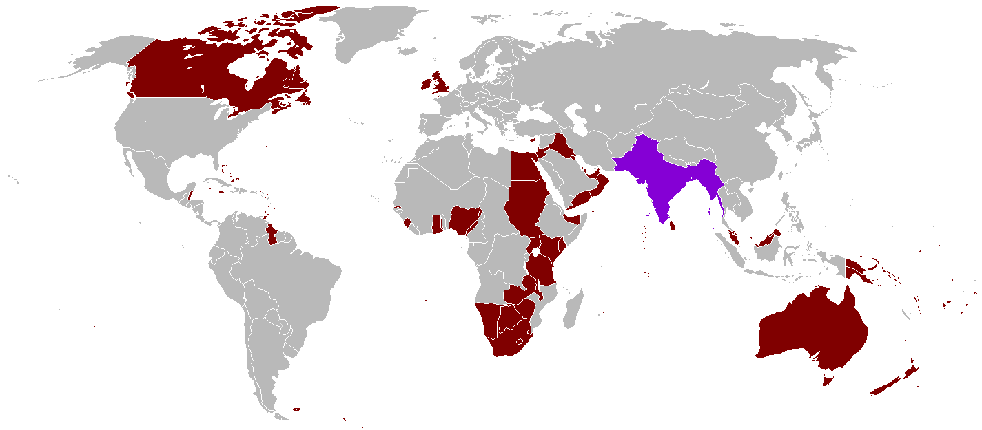
English: A map of the British Empire in 1921 when it was at its height with British India indicated when it too was at its height as well. |
|||
| Datum | Uploaded on 27 Augustus 2008, 21:41. | |||
| Bron | Eie werk | |||
| Outeur | Vadac. | |||
| Toestemming (Hergebruik van die lêer) |
|
|||
| Ander weergawes | File:British Empire 1921.png, File:British and French empires 1920.png |

|
This historical map image could be re-created using vector graphics as an SVG file. This has several advantages; see Commons:Media for cleanup for more information. If an SVG form of this image is available, please upload it and afterwards replace this template with
{{vector version available|new image name}}.
It is recommended to name the SVG file “British Empire 1921 IndianSubcontinent.svg”—then the template Vector version available (or Vva) does not need the new image name parameter. |
Captions
Add a one-line explanation of what this file represents
Items portrayed in this file
uitbeelding
some value
source of file Engels
27 Augustus 2008
media type Engels
image/png
checksum Engels
935a8207c6efd79b6497ccded2c46d1acda52b0f
data size Engels
40 066 greep
height Engels
625 pieksel
width Engels
1 425 pieksel
Lêergeskiedenis
Klik op die datum/tyd om te sien hoe die lêer destyds gelyk het.
| Datum/Tyd | Duimnael | Dimensies | Gebruiker | Opmerking | |
|---|---|---|---|---|---|
| huidig | 07:59, 31 Oktober 2021 | | 1 425 × 625 (39 KG) | Randomastwritter | . |
| 22:25, 13 Augustus 2016 |  | 1 425 × 625 (39 KG) | RickoTroanman22 | Tibet re-added | |
| 18:58, 7 Mei 2011 |  | 1 425 × 625 (50 KG) | Quigley | Correct China's borders closer to what was internationally recognized at the time | |
| 01:42, 13 Oktober 2010 |  | 1 425 × 625 (50 KG) | Vadac | Aden was not part of the British Raj. Matched map to File:British Empire 1921.png | |
| 18:03, 11 Januarie 2006 |  | 1 345 × 614 (28 KG) | Miljoshi | More Changes as per w:Talk:British Raj. | |
| 10:21, 9 Januarie 2006 |  | 1 345 × 614 (28 KG) | Miljoshi | Correcting wrong inclusion of Nicaragua - w:User:Big Adamsky | |
| 11:51, 6 Januarie 2006 |  | 1 345 × 614 (22 KG) | Miljoshi | Discounting Sri Lanka | |
| 10:30, 6 Januarie 2006 |  | 1 345 × 614 (22 KG) | Miljoshi | Updated map with corrections in Aden, Lebanon, Nicaragua, New Caledonia, Goa, Daman, Pondycherri. | |
| 17:01, 5 Januarie 2006 |  | 1 345 × 614 (23 KG) | Miljoshi | British Empire in 1921 - Indian subcontinent is highlighted in purple. Image based on GFDL Image:British Empire 1921.png by w:Arthur Wellesley |
Lêergebruik
Die volgende bladsy gebruik dié lêer:
Globale lêergebruik
Die volgende ander wiki's gebruik hierdie lêer:
- Gebruik in bg.wikipedia.org
- Gebruik in da.wikipedia.org
- Gebruik in de.wikipedia.org
- Gebruik in en.wikipedia.org
- Gebruik in es.wikipedia.org
- Gebruik in hy.wikipedia.org
- Gebruik in id.wikipedia.org
- Gebruik in kk.wikipedia.org
- Gebruik in kn.wikipedia.org
- Gebruik in ml.wikipedia.org
- Gebruik in nl.wikipedia.org
- Gebruik in nn.wikipedia.org
- Gebruik in no.wikipedia.org
- Gebruik in ru.wikipedia.org
- Gebruik in tum.wikipedia.org
- Gebruik in uz.wikipedia.org
- Gebruik in vep.wikipedia.org
Metadata
Die lêer bevat aanvullende inligting wat moontlik deur 'n digitale kamera of skandeerder bygevoeg is.
As die lêer verander is, sal sekere inligting dalk nie meer ooreenkom met dié van die gewysigde lêer nie.
| Horisontale resolusie | 47,24 dpc |
|---|---|
| Vertikale resolusie | 47,24 dpc |
| Tydstip laaste lêerwysiging | 22:48, 1 November 2007 |