Lêer:Vesuvius_79_AD_eruption-la.svg
From Wikipedia, the free encyclopedia

Oorspronklike lêer (SVG-lêer, normaalweg 800 × 480 piksels, lêergrootte: 86 KG)
Hierdie lêer kom vanaf Wikimedia Commons en kan ook in ander projekte gebruik word. Die beskrywing op die lêer se inligtingsblad word hieronder weergegee.
Opsomming
| BeskrywingMt Vesuvius 79 AD eruption-la.svg |
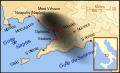
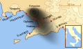
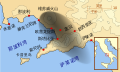
English: A map showing the cities and towns (with their Latin names which were affected by the eruption of Mount Vesuvius in 79 AD ; the general shape of the ash and cinder fall —see w:en:pyroclast— is shown by the dark area to the southeast of Mt Vesuvius.
This map shows modern day coast lines and uses the Mercator projection (although that is not important on a map of this scale). North is, as usual, at the top of the map. Español: El mapa muestra las ciudades y los poblados (con sus nombres en latín) que fueron afectados por la erupción del Vesubio del año 79 d.C. ; las cenizas y los residuos de la erupción volcánica —consultar Piroclasto (tefra)— cayeron al sureste del Monte Vesubio, donde está indicado por la zona oscurecida. |
| Datum | |
| Bron | Eie werk |
| Outeur | MapMaster |
References
This map is intended to show the general distribution of (airborne) ash punice, and other particles. I built the map from descriptions of the event as well as these maps:
- Luongo, Giuseppe; Perrotta, Annamaria; Scarpati, Claudio;De Carolis, Ernesto;Patricelli, Giovanni;Ciarallo, Annamaria (2003) "Impact of the AD 79 explosive eruption on Pompeii" in Journal of Volcanology and Geothermal Research v126 pp. 169-200.
- This map.
- Image:Pompeya, el Vesuvio y su alcance.jpg
Other versions
[wysig]
-
 English
 -
 français
 -
 Latina
 -
 Nederlands
 -
 português
 -
 македонски
 -
 русский
 -
 中文
中文 -
 עברית
עברית


| This SVG file contains embedded text that can be translated into your language, using any capable SVG editor, text editor or the SVG Translate tool. For more information see: About translating SVG files. |
Lisensiëring

|
Toestemming word verleen tot die kopiëring, verspreiding en/of wysiging van hierdie dokument onder die voorwaardes van die GNU-lisensie vir vrye dokumentasie, weergawe 1.2 of enige latere weergawe uitgegee deur die Stigting vir Vrye Sagteware, sonder Invariante Dele, geen Voorbladtekste en geen Agterbladtekste. 'n Kopie van hierdie lisensie is ingesluit in die afdeling getiteld GNU Free Documentation License.http://www.gnu.org/copyleft/fdl.htmlGFDLGNU Free Documentation Licensetruetrue |
- U is vry:
- om te deel – die werk kopieer, versprei en deurgee
- om te hermeng – om die werk aan te pas
- Onder die volgende voorwaardes:
- naamsvermelding – U moet die nodige krediet gee, 'n skakel na die lisensie verskaf en aandui of daar veranderinge aangebring is. U mag dit op enige redelike manier doen, maar nie op enige manier wat daarop dui dat die lisensiegewer u of u gebruik onderskryf nie.
- insgelyks – As u die materiaal hermix, transformeer of voortbou, moet u u bydraes versprei onder die dieselfde of versoenbare lisensie as die oorspronklike.
Captions
Items portrayed in this file
uitbeelding
some value
copyrighted Engels
Oktober 2007
source of file Engels
Lêergeskiedenis
Klik op die datum/tyd om te sien hoe die lêer destyds gelyk het.
| Datum/Tyd | Duimnael | Dimensies | Gebruiker | Opmerking | |
|---|---|---|---|---|---|
| huidig | 08:00, 6 April 2018 | | 800 × 480 (86 KG) | -donald- | K changed to km |
| 22:04, 28 November 2014 |  | 800 × 480 (88 KG) | Ras67 | frame removed | |
| 00:17, 19 Oktober 2007 |  | 659 × 396 (113 KG) | MapMaster | slight modification | |
| 22:35, 15 Oktober 2007 |  | 659 × 396 (113 KG) | MapMaster | slight image fix-up | |
| 17:52, 15 Oktober 2007 |  | 652 × 396 (113 KG) | MapMaster | == Summary == {{Information |Description=A map showing the cities and towns affected by the eruption of Mount Vesuvius in 79 AD. The general shape of the ash and cinder fall (see w:en:pyroclast) is shown by the dark area to the southeast of Mt Vesuvi |
Lêergebruik
Die volgende 3 bladsye gebruik dié lêer:
Globale lêergebruik
Die volgende ander wiki's gebruik hierdie lêer:
- Gebruik in bar.wikipedia.org
- Gebruik in bg.wikipedia.org
- Gebruik in br.wikipedia.org
- Gebruik in ca.wikipedia.org
- Gebruik in cs.wikipedia.org
- Gebruik in da.wikipedia.org
- Gebruik in de.wikipedia.org
- Gebruik in de.wikivoyage.org
- Gebruik in en.wikipedia.org
- Gebruik in es.wikipedia.org
- Gebruik in et.wikipedia.org
- Gebruik in fi.wikipedia.org
- Gebruik in fr.wikipedia.org
- Gebruik in fur.wikipedia.org
- Gebruik in fy.wikipedia.org
- Gebruik in gl.wikipedia.org
Wys meer globale gebruik van die lêer.
Metadata
Die lêer bevat aanvullende inligting wat moontlik deur 'n digitale kamera of skandeerder bygevoeg is.
As die lêer verander is, sal sekere inligting dalk nie meer ooreenkom met dié van die gewysigde lêer nie.
| Breedte | 800 |
|---|---|
| Hoogte | 480 |