File:Ancient_tamilakam_ports.png
From Wikipedia, the free encyclopedia
Original file (4,984 × 4,925 pixels, file size: 9 MB, MIME type: image/png)
| This is a file from the Wikimedia Commons. Information from its description page there is shown below. Commons is a freely licensed media file repository. You can help. |
Summary
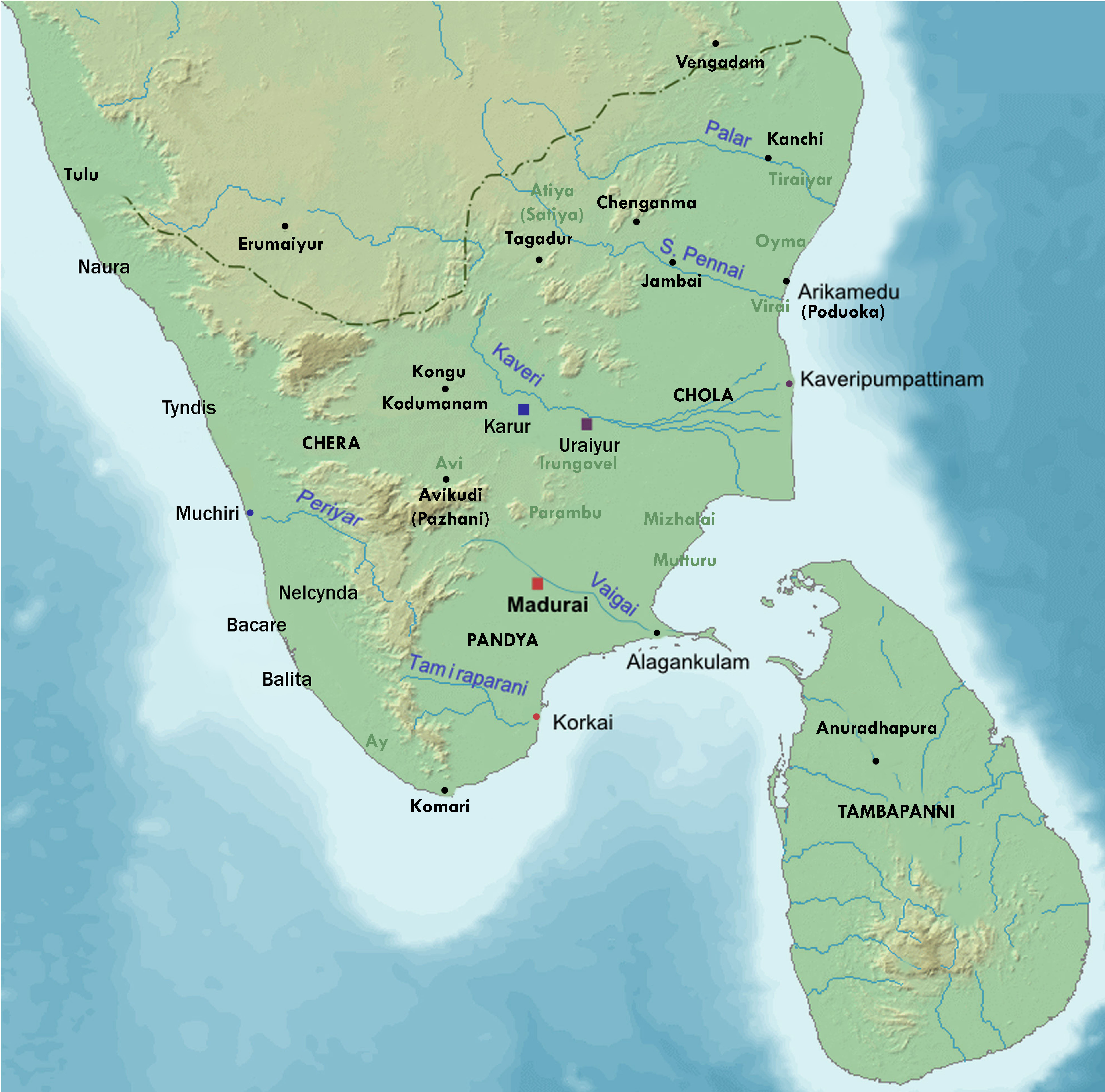
| DescriptionAncient tamilakam ports.png | Map showing the important port cities of ancient Tamil country and its approximate northern boundary |
| Date | |
| Source |
Source of map: http://www2.demis.nl/mapserver/mapper.asp (mention : "Disclaimer: With this statement DEMIS BV grants you permission to freely copy the PNG images returned by our server and use them for your own purposes, including web pages. We would appreciate a reference to our server but such a reference is not required, nor do we take responsibility for the accuracy or quality of the maps". at http://www2.demis.nl/mapserver/DataSrc.htm) Modified by me using Inkscape. |
| Author | Lotlil |
Licensing
| Public domainPublic domainfalsefalse |
| This work has been released into the public domain by its author, I, Lotlil. This applies worldwide. In some countries this may not be legally possible; if so: I, Lotlil grants anyone the right to use this work for any purpose, without any conditions, unless such conditions are required by law. |
Captions
Items portrayed in this file
depicts
7 August 2007
image/png
3ec8144553755a664da28f4e9519a49cf82a481b
9,441,666 byte
4,925 pixel
4,984 pixel
File history
Click on a date/time to view the file as it appeared at that time.
| Date/Time | Thumbnail | Dimensions | User | Comment | |
|---|---|---|---|---|---|
| current | 07:24, 29 November 2019 | | 4,984 × 4,925 (9 MB) | StephenPaa | Added more locations |
| 09:41, 29 August 2019 |  | 2,000 × 2,000 (2.61 MB) | StephenPaa | Added Karur | |
| 08:57, 29 August 2019 |  | 2,000 × 2,000 (2.61 MB) | StephenPaa | Corrected the colour of some ports and the Chera country | |
| 04:49, 7 August 2007 |  | 800 × 800 (385 KB) | Lotlil | {{Information |Description=Map showing the important port cities of ancient Tamil country and its approximate northern boundary |Source=Source of map: http://www2.demis.nl/mapserver/mapper.asp (mention : "Disclaimer: With this statement DEMIS BV grants yo | |
| 04:41, 7 August 2007 |  | 800 × 800 (385 KB) | Lotlil | {{Information |Description=Map showing the important port cities of ancient Tamil country and its approximate northern boundary |Source=Source of map: http://www2.demis.nl/mapserver/mapper.asp (mention : "Disclaimer: With this statement DEMIS BV grants yo |
File usage
Global file usage
The following other wikis use this file:
- Usage on ar.wikipedia.org
- Usage on de.wikipedia.org
- Usage on hu.wikipedia.org
- Usage on ko.wikipedia.org
Metadata
This file contains additional information, probably added from the digital camera or scanner used to create or digitize it.
If the file has been modified from its original state, some details may not fully reflect the modified file.
| Width | 4,984 px |
|---|---|
| Height | 4,925 px |
| Bits per component |
|
| Pixel composition | RGB |
| Number of components | 3 |
| Horizontal resolution | 89.992 dpi |
| Vertical resolution | 89.992 dpi |
| Exif version | 2.21 |
| Color space | sRGB |
| Image width | 4,984 px |
| Image height | 4,925 px |
| Unique ID of original document | uuid:E10360C87612EA11B962A1A78764ABE4 |
| Date and time of digitizing | 18:16, 29 November 2019 |
| File change date and time | 18:21, 29 November 2019 |
| Date metadata was last modified | 18:21, 29 November 2019 |
| Software used | Adobe Photoshop CC 2017 (Windows) |
| Copyright status | Copyright status not set |