File:Argentina_Córdoba_topographic_location_map.png
From Wikipedia, the free encyclopedia
Size of this preview: 389 × 599 pixels. Other resolutions: 156 × 240 pixels | 499 × 768 pixels.
Original file (499 × 768 pixels, file size: 77 KB, MIME type: image/png)
| This is a file from the Wikimedia Commons. Information from its description page there is shown below. Commons is a freely licensed media file repository. You can help. |
Summary
| DescriptionArgentina Córdoba topographic location map.png |
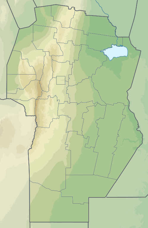
English: Topographic location map of Córdoba province (Argentina).
Español: Mapa topográfico de localización en la provincia de Córdoba (Argentina).
Equirectangular projection, N/S stretching 117.5 %. Geographic limits of the map:
|
| Date | |
| Source | Own work based on: Argentina Córdoba location map.svg, elevation data: GEBCO 2022 |
| Author | GrandEscogriffe, Milenioscuro |
| Other versions |
|

Licensing
I, the copyright holder of this work, hereby publish it under the following license:
This file is licensed under the Creative Commons Attribution-Share Alike 4.0 International license.
- You are free:
- to share – to copy, distribute and transmit the work
- to remix – to adapt the work
- Under the following conditions:
- attribution – You must give appropriate credit, provide a link to the license, and indicate if changes were made. You may do so in any reasonable manner, but not in any way that suggests the licensor endorses you or your use.
- share alike – If you remix, transform, or build upon the material, you must distribute your contributions under the same or compatible license as the original.
Captions
Add a one-line explanation of what this file represents
Items portrayed in this file
depicts
27 December 2022
image/png
699753ff940c9a4e1ac0937a865a9fc91c91eedf
78,576 byte
768 pixel
499 pixel
File history
Click on a date/time to view the file as it appeared at that time.
| Date/Time | Thumbnail | Dimensions | User | Comment | |
|---|---|---|---|---|---|
| current | 15:05, 27 December 2022 | | 499 × 768 (77 KB) | GrandEscogriffe | Uploaded own work with UploadWizard |
File usage
No pages on the English Wikipedia use this file (pages on other projects are not listed).
Global file usage
The following other wikis use this file:
- Usage on es.wikipedia.org
- Sierras de Córdoba
- Laguna Mar Chiquita (Córdoba)
- Sierras Chicas
- Champaquí
- Uritorco
- Valle de Calamuchita
- Embalse Ministro Pistarini
- Cerro Pan de Azúcar (Córdoba)
- Plantilla:Mapa de localización de Provincia de Córdoba (Argentina)
- Wikiproyecto:Ilustración/Taller de Cartografía/Realizaciones/América del Sur
- Cerro Mogote
- Usage on fr.wikipedia.org
- Córdoba (Argentine)
- Villa Carlos Paz
- Mar Chiquita
- Jesús María (Argentine)
- Embalse
- Río Cuarto (ville)
- San Agustín (Argentine)
- Villa Huidobro
- Villa María
- Deán Funes
- La Carlota (Argentine)
- Marcos Juárez
- San Carlos Minas
- Salsacate
- Laboulaye
- Cosquín
- Santa Rosa de Río Primero
- Villa del Rosario (Argentine)
- Villa Cura Brochero
- Villa Dolores
- San Francisco (Argentine)
- Alta Gracia
- San Francisco del Chañar
- Oliva (Argentine)
- Villa del Totoral
- Villa Tulumba
- Bell Ville
- Villa Allende
- Modèle:Géolocalisation/Córdoba (Argentine)
- La Falda
- Villa General Belgrano
- Champaquí
- Arias (Córdoba)
- Colonia Caroya
- Usage on he.wikipedia.org