File:Be-map.png
From Wikipedia, the free encyclopedia

Be-map.png (559 × 600 pixels, file size: 176 KB, MIME type: image/png)
| This is a file from the Wikimedia Commons. Information from its description page there is shown below. Commons is a freely licensed media file repository. You can help. |

|
This locator map image could be re-created using vector graphics as an SVG file. This has several advantages; see Commons:Media for cleanup for more information. If an SVG form of this image is available, please upload it and afterwards replace this template with
{{vector version available|new image name}}.
It is recommended to name the SVG file “Be-map.svg”—then the template Vector version available (or Vva) does not need the new image name parameter. |
Summary
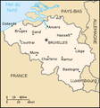
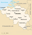
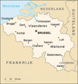
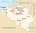
| DescriptionBe-map.png | Belgium map from CIA World Factbook (since 8 May 2006), converted from original GIF format | |||
| Date | ||||
| Source |
CIA World Factbook |
|||
| Author | United States Central Intelligence Agency | |||
| Other versions |
|
.png)
Licensing
| Public domainPublic domainfalsefalse |
This image is in the public domain because it contains materials that originally came from the United States Central Intelligence Agency's World Factbook.
Bahasa Indonesia ∙ čeština ∙ Deutsch ∙ eesti ∙ English ∙ español ∙ Esperanto ∙ français ∙ galego ∙ hrvatski ∙ italiano ∙ Nederlands ∙ norsk nynorsk ∙ polski ∙ português ∙ sicilianu ∙ slovenščina ∙ suomi ∙ Türkçe ∙ Zazaki ∙ беларуская (тарашкевіца) ∙ македонски ∙ русский ∙ српски / srpski ∙ українська ∙ ქართული ∙ বাংলা ∙ தமிழ் ∙ മലയാളം ∙ 한국어 ∙ 日本語 ∙ 中文 ∙ 中文(简体) ∙ 中文(繁體) ∙ العربية ∙ +/− |
 |
Derivative works
Derivatives of 2006 map:


Derivatives of 2004 map:


Derivatives of 2000 map:
-
 Belgie-mapa.PNG
čeština -
 Be-map-eo.png
Esperanto -
 Be-map-es.png
español -
 Be-map-fr.png
français -
 Be-map-nl.png
Nederlands -
 Belgium-map-nl.png
Nederlands -
 Belgium üres.png
 -
 Ath in Belgium.png
 -
 Dendermonde location map.png
 -
 Vlaamse ruit.png


Captions
Items portrayed in this file
depicts
8 May 2006
image/png
58d4b9ea4d64a1511a1c3f234d9194c27422eab5
180,575 byte
600 pixel
559 pixel
File history
Click on a date/time to view the file as it appeared at that time.
| Date/Time | Thumbnail | Dimensions | User | Comment | |
|---|---|---|---|---|---|
| current | 21:48, 13 April 2020 | | 559 × 600 (176 KB) | Le Fou | Zeebrugge is not a city, but part of the city of Bruges. |
| 19:13, 21 July 2018 |  | 1,024 × 1,099 (24 KB) | Karel Adriaan | Resized to 1024 | |
| 20:48, 20 April 2007 |  | 328 × 353 (12 KB) | Tene~commonswiki | Optimised (0) | |
| 17:07, 11 March 2007 |  | 328 × 353 (13 KB) | Feydey | 2007 factbook map | |
| 13:55, 27 May 2006 |  | 329 × 353 (20 KB) | Matt314 | "Redu" in the same font size as the other cities | |
| 20:59, 7 April 2006 |  | 329 × 353 (20 KB) | Abrev | Map of Belgium Updated version uploaded by [http://de.wikipedia.org/wiki/Benutzer:Tzzzpfff]. No rights reserved for updating. | |
| 16:46, 5 January 2006 |  | 330 × 355 (9 KB) | Jrenier | Reverted to earlier revision | |
| 16:35, 5 January 2006 |  | 330 × 355 (9 KB) | Jrenier | Reverted to earlier revision | |
| 19:53, 3 January 2006 |  | 330 × 355 (28 KB) | Iunity | ||
| 19:24, 27 November 2004 |  | 330 × 355 (9 KB) | Kneiphof | Map of Belgium, CIA factbook (taken from EN Wikipedia) |
File usage
Global file usage
The following other wikis use this file:
- Usage on als.wikipedia.org
- Usage on ay.wikipedia.org
- Usage on azb.wikipedia.org
- Usage on az.wikipedia.org
- Usage on bar.wikipedia.org
- Usage on bcl.wikipedia.org
- Usage on be-tarask.wikipedia.org
- Usage on bg.wiktionary.org
- Usage on bn.wikipedia.org
- Usage on bs.wikipedia.org
- Usage on ca.wikipedia.org
- Usage on de.wikipedia.org
- Usage on de.wikinews.org
- Usage on dsb.wikipedia.org
- Usage on en.wikinews.org
- Usage on en.wikivoyage.org
- Usage on en.wiktionary.org
- Usage on es.wikipedia.org
- Usage on fa.wikipedia.org
- Usage on fi.wikipedia.org
- Usage on fr.wikipedia.org
- Usage on fr.wikinews.org
- Usage on gag.wikipedia.org
- Usage on ga.wikipedia.org
- Usage on gl.wikipedia.org
- Usage on ha.wikipedia.org
- Usage on hi.wikipedia.org
- Usage on hy.wikipedia.org
- Usage on incubator.wikimedia.org
- Usage on io.wikipedia.org
- Usage on it.wikinews.org
- Usage on it.wiktionary.org
- Usage on ja.wikipedia.org
- Usage on ja.wikibooks.org
View more global usage of this file.
Metadata
This file contains additional information, probably added from the digital camera or scanner used to create or digitize it.
If the file has been modified from its original state, some details may not fully reflect the modified file.
| Horizontal resolution | 28.35 dpc |
|---|---|
| Vertical resolution | 28.35 dpc |