File:Belle-ile_on_nasa_map.jpg
From Wikipedia, the free encyclopedia
No higher resolution available.
Belle-ile_on_nasa_map.jpg (403 × 388 pixels, file size: 47 KB, MIME type: image/jpeg)
| This is a file from the Wikimedia Commons. Information from its description page there is shown below. Commons is a freely licensed media file repository. You can help. |
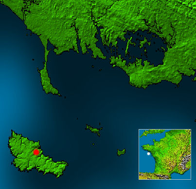
White point on mini France map marks location of w:Belle-Île. Red point marks the city w:Le Palais on Belle-Île.
- This map is based on a NASA work, which is considered to be public domain (see box below), source: http://photojournal.jpl.nasa.gov/catalog/PIA03393
- Edits by Matthäus Wander are licensed unter GFDL, see box
| Public domainPublic domainfalsefalse |
This image uses high-resolution digital topography data from NASA's Shuttle Radar Topography Mission (SRTM) at JPL-Caltech [1]. It is in the public domain in the United States.
|
 | |
| English | Bahasa Indonesia | македонски | polski | português | 中文 | 中文(简体) | +/− |

|
Permission is granted to copy, distribute and/or modify this document under the terms of the GNU Free Documentation License, Version 1.2 or any later version published by the Free Software Foundation; with no Invariant Sections, no Front-Cover Texts, and no Back-Cover Texts. A copy of the license is included in the section entitled GNU Free Documentation License.http://www.gnu.org/copyleft/fdl.htmlGFDLGNU Free Documentation Licensetruetrue |
| This file is licensed under the Creative Commons Attribution-Share Alike 3.0 Unported license. | ||
| ||
| This licensing tag was added to this file as part of the GFDL licensing update.http://creativecommons.org/licenses/by-sa/3.0/CC BY-SA 3.0Creative Commons Attribution-Share Alike 3.0truetrue |
Captions
Add a one-line explanation of what this file represents
Items portrayed in this file
depicts
image/jpeg
9020b3a8aef55f42ad807b98dcd79552e0a03e62
47,840 byte
388 pixel
403 pixel
File history
Click on a date/time to view the file as it appeared at that time.
| Date/Time | Thumbnail | Dimensions | User | Comment | |
|---|---|---|---|---|---|
| current | 00:28, 19 April 2005 | | 403 × 388 (47 KB) | Matthäus Wander | White point on mini France map marks location of w:Belle-Île. Red point marks the city w:Le Palais on Belle-Île. * This map is based on a NASA work, which is considered to be public domain (see box below), source: http://photojournal.jpl.nasa.g |
File usage
The following pages on the English Wikipedia use this file (pages on other projects are not listed):
Global file usage
The following other wikis use this file:
- Usage on ceb.wikipedia.org
- Usage on el.wikipedia.org
- Usage on en.wikivoyage.org
- Usage on es.wikipedia.org
- Usage on et.wikipedia.org
- Usage on id.wikipedia.org
- Usage on it.wikipedia.org
- Usage on ja.wikipedia.org
- Usage on ko.wikipedia.org
- Usage on nn.wikipedia.org
- Usage on pt.wikipedia.org
- Usage on ru.wikipedia.org
- Usage on sl.wikipedia.org
- Usage on sv.wikipedia.org
- Usage on uk.wikipedia.org
- Usage on zh.wikipedia.org
Metadata
This file contains additional information, probably added from the digital camera or scanner used to create or digitize it.
If the file has been modified from its original state, some details may not fully reflect the modified file.
| _error | 0 |
|---|
Retrieved from "https://en.wikipedia.org/wiki/File:Belle-ile_on_nasa_map.jpg"