File:Borneo2_map_english_names.PNG
From Wikipedia, the free encyclopedia
Size of this preview: 539 × 600 pixels. Other resolutions: 216 × 240 pixels | 431 × 480 pixels | 690 × 768 pixels | 1,063 × 1,183 pixels.
Original file (1,063 × 1,183 pixels, file size: 236 KB, MIME type: image/png)
| This is a file from the Wikimedia Commons. Information from its description page there is shown below. Commons is a freely licensed media file repository. You can help. |
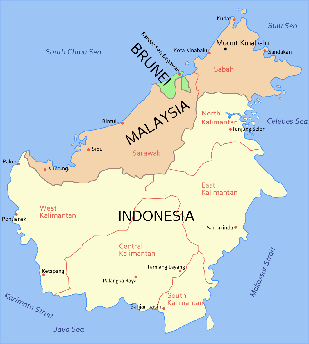
Summary
(English) Political map of Borneo, based on information from several maps.
- Light yellow = Indonesia
- Light orange = Malaysia
- Green = Brunei
For a blank political map see Image:Borneo blank map.PNG
(Bahasa Melayu) Peta Borneo, berdasarkan maklumat dari beberapa peta berlainan.
- Kuning cair = Indonesia
- Oren cair = Malaysia
- Hijau = Brunei
Untuk melihat peta Borneo kosong, sila ke Image:Borneo blank map.PNG

|
File:Borneo2 map english names.svg is a vector version of this file. It should be used in place of this PNG file when not inferior.
File:Borneo2 map english names.PNG → File:Borneo2 map english names.svg
For more information, see Help:SVG.
|
 |
Licensing

|
Permission is granted to copy, distribute and/or modify this document under the terms of the GNU Free Documentation License, Version 1.2 or any later version published by the Free Software Foundation; with no Invariant Sections, no Front-Cover Texts, and no Back-Cover Texts. A copy of the license is included in the section entitled GNU Free Documentation License.http://www.gnu.org/copyleft/fdl.htmlGFDLGNU Free Documentation Licensetruetrue |
| This file is licensed under the Creative Commons Attribution-Share Alike 3.0 Unported license. | ||
| ||
| This licensing tag was added to this file as part of the GFDL licensing update.http://creativecommons.org/licenses/by-sa/3.0/CC BY-SA 3.0Creative Commons Attribution-Share Alike 3.0truetrue |
Captions
Add a one-line explanation of what this file represents
Items portrayed in this file
depicts
image/png
40f5635211fe987b75e77b9a9ab4c87a079847d1
241,272 byte
1,183 pixel
1,063 pixel
File history
Click on a date/time to view the file as it appeared at that time.
| Date/Time | Thumbnail | Dimensions | User | Comment | |
|---|---|---|---|---|---|
| current | 15:54, 30 October 2012 | | 1,063 × 1,183 (236 KB) | Exagren | revision, +North Kalimantan |
| 12:49, 24 June 2006 |  | 1,063 × 1,183 (73 KB) | Roke~commonswiki | blue text labels on ocean | |
| 10:41, 20 February 2006 |  | 1,063 × 1,183 (69 KB) | Roke~commonswiki | Map of Borneo, based on information from several maps. *Light yellow = Indonesia *Light Orange = Malaysia *Green = Brunei For a blank map see Image:Borneo blank map.PNG Category: Indonesia Category: Malaysia Category: Brunei |
File usage
The following pages on the English Wikipedia use this file (pages on other projects are not listed):
Global file usage
The following other wikis use this file:
- Usage on ar.wikipedia.org
- Usage on bcl.wikipedia.org
- Usage on br.wikipedia.org
- Usage on ca.wikipedia.org
- Usage on ceb.wikipedia.org
- Usage on ckb.wikipedia.org
- Usage on cs.wikipedia.org
- Usage on cy.wikipedia.org
- Usage on da.wikipedia.org
- Usage on fi.wikipedia.org
- Usage on frr.wikipedia.org
- Usage on fr.wikipedia.org
- Usage on fr.wikinews.org
- Usage on gd.wikipedia.org
- Usage on he.wikipedia.org
- Usage on id.wikipedia.org
- Usage on ja.wikipedia.org
- Usage on jv.wikipedia.org
- Usage on la.wikipedia.org
- Usage on map-bms.wikipedia.org
- Usage on min.wikipedia.org
- Usage on mr.wikipedia.org
- Usage on ms.wikipedia.org
- Usage on nl.wikipedia.org
- Usage on nn.wikipedia.org
- Usage on no.wikipedia.org
- Usage on pam.wikipedia.org
- Usage on pl.wikipedia.org
- Usage on pt.wikipedia.org
- Usage on scn.wikipedia.org
- Usage on sk.wikipedia.org
- Usage on sv.wikipedia.org
- Usage on ta.wikipedia.org
- Usage on ta.wikinews.org
- Usage on tg.wikipedia.org
- Usage on tl.wikipedia.org
- Usage on tr.wiktionary.org
- Usage on ur.wikipedia.org
Metadata
This file contains additional information, probably added from the digital camera or scanner used to create or digitize it.
If the file has been modified from its original state, some details may not fully reflect the modified file.
| Horizontal resolution | 35.43 dpc |
|---|---|
| Vertical resolution | 35.43 dpc |
| Software used |
Retrieved from "https://en.wikipedia.org/wiki/File:Borneo2_map_english_names.PNG"