File:Burnham,_St_Peter's_Church_-_geograph.org.uk_-_1118895.jpg
From Wikipedia, the free encyclopedia
No higher resolution available.
Burnham,_St_Peter's_Church_-_geograph.org.uk_-_1118895.jpg (640 × 480 pixels, file size: 69 KB, MIME type: image/jpeg)
| This is a file from the Wikimedia Commons. Information from its description page there is shown below. Commons is a freely licensed media file repository. You can help. |
Summary
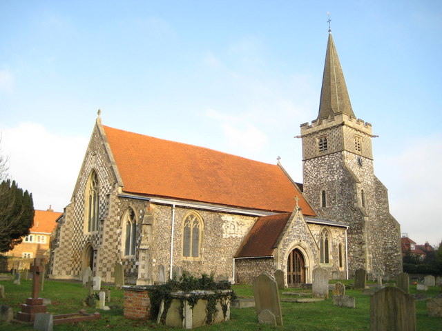
| DescriptionBurnham, St Peter's Church - geograph.org.uk - 1118895.jpg |
English: Church of England parish church of Saint Peter, Burnham, Buckinghamshire: view from the southwest. The tower was built in the 13th century, but its top was rebuilt in 1864 |
| Date | |
| Source | From geograph.org.uk |
| Author | Nigel Cox |
| Attribution (required by the license) InfoField | Nigel Cox / Burnham: St Peter's Church / |
InfoField | Nigel Cox / Burnham: St Peter's Church |
| Camera location | 51° 31′ 57″ N, 0° 39′ 37″ W | View this and other nearby images on: OpenStreetMap |
|---|
| Object location | 51° 31′ 58″ N, 0° 39′ 35″ W | View this and other nearby images on: OpenStreetMap |
|---|
Licensing

|
This image was taken from the Geograph project collection. See this photograph's page on the Geograph website for the photographer's contact details. The copyright on this image is owned by Nigel Cox and is licensed for reuse under the Creative Commons Attribution-ShareAlike 2.0 license.
|
This file is licensed under the Creative Commons Attribution-Share Alike 2.0 Generic license.
Attribution: Nigel Cox
- You are free:
- to share – to copy, distribute and transmit the work
- to remix – to adapt the work
- Under the following conditions:
- attribution – You must give appropriate credit, provide a link to the license, and indicate if changes were made. You may do so in any reasonable manner, but not in any way that suggests the licensor endorses you or your use.
- share alike – If you remix, transform, or build upon the material, you must distribute your contributions under the same or compatible license as the original.
Captions
Add a one-line explanation of what this file represents
Items portrayed in this file
depicts
some value
51°31'57.14"N, 0°39'37.44"W
9 January 2009
51°31'58.40"N, 0°39'35.28"W
image/jpeg
4fd60a87669e1c77f02949f0290f549c26f2fd50
71,130 byte
480 pixel
640 pixel
File history
Click on a date/time to view the file as it appeared at that time.
| Date/Time | Thumbnail | Dimensions | User | Comment | |
|---|---|---|---|---|---|
| current | 20:40, 24 February 2011 | | 640 × 480 (69 KB) | GeographBot | == {{int:filedesc}} == {{Information |description={{en|1=Burnham: St Peter's Church The church with its distinctive chequer-patterned west end dates in parts from the 12th century. Its website is here http://www.stpetersburnham.org/}} |date=2009-01-09 |so |
File usage
The following pages on the English Wikipedia use this file (pages on other projects are not listed):
Global file usage
The following other wikis use this file:
- Usage on ar.wikipedia.org
- Usage on arz.wikipedia.org
- Usage on ceb.wikipedia.org
- Usage on cy.wikipedia.org
- Usage on de.wikipedia.org
- Usage on fa.wikipedia.org
- Usage on fr.wikipedia.org
- Usage on it.wikipedia.org
- Usage on lld.wikipedia.org
- Usage on pt.wikipedia.org
- Usage on sv.wikipedia.org
- Usage on www.wikidata.org
- Usage on zh-min-nan.wikipedia.org
Metadata
This file contains additional information, probably added from the digital camera or scanner used to create or digitize it.
If the file has been modified from its original state, some details may not fully reflect the modified file.
| _error | 0 |
|---|