File:Canada_topo.jpg
From Wikipedia, the free encyclopedia
Original file (1,400 × 1,211 pixels, file size: 791 KB, MIME type: image/jpeg)
| This is a file from the Wikimedia Commons. Information from its description page there is shown below. Commons is a freely licensed media file repository. You can help. |
Hhhdndicidm
Summary
| DescriptionCanada topo.jpg |
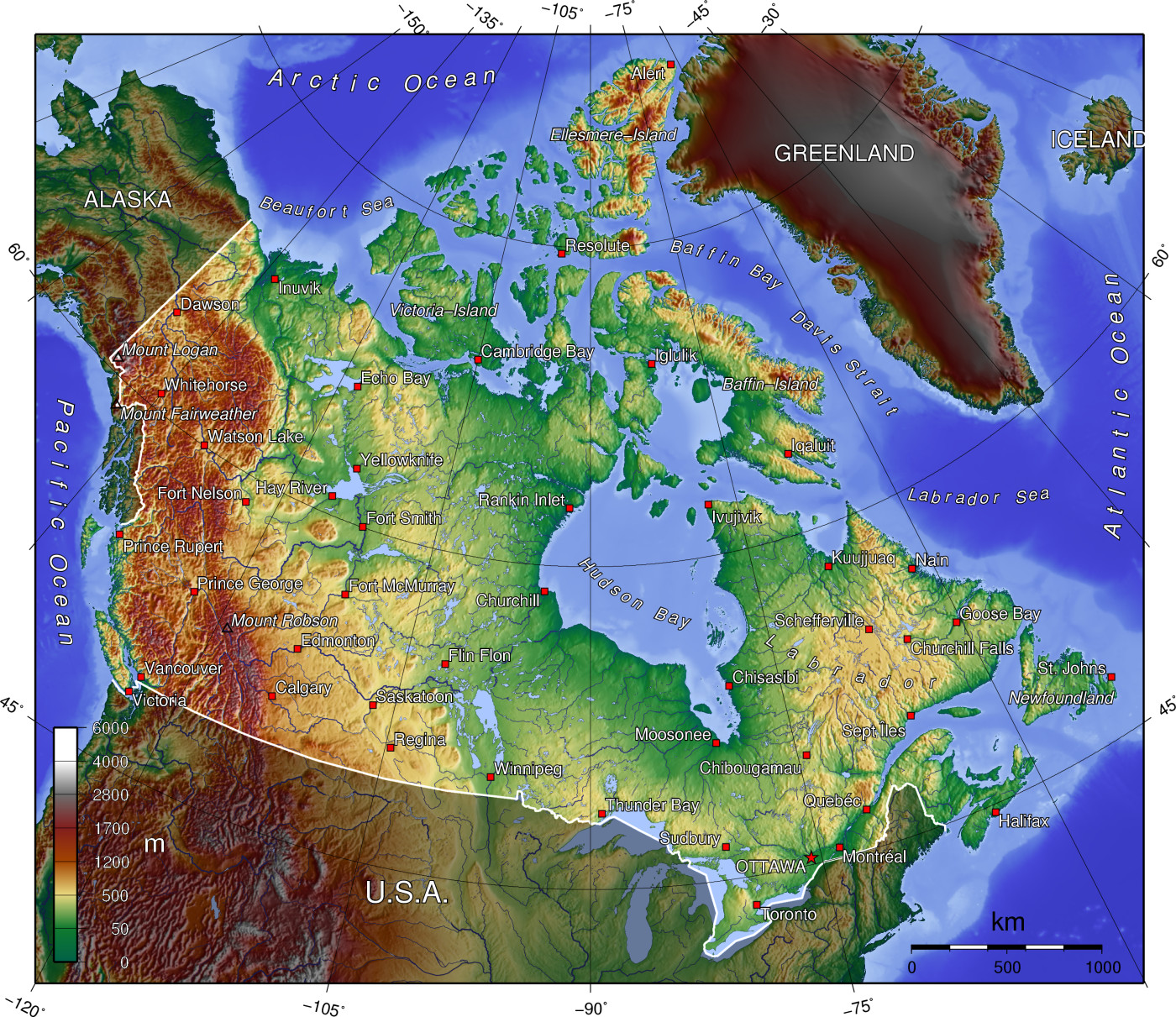
A topographic map of Canada, in polar projection (for 90° W), showing elevations shaded from green to brown (higher), with elevation-legend overlaid at lower left. Nearby countries are shaded darker (compare elevation shades at Canadian borders). The image is centered over longitude 90° W, with longitude meridians at 15-degree intervals apart, and latitude parallels also 15-degree. The boundaries are roughly from longitude 10°W to 177°W, and latitude 40°N to 84°N (above northern-most Alert, Canada 82°28′N, 62°30′W). |
| Date | 14-April-2006 (English Wikipedia image of 7-July-2005) |
| Source | From English Wikipedia image of 7-July-2005, same name: en:Image:Canada topo.jpg (which now points here to Commons). |
| Author | User:Anchjo (from en:Wikipedia User:Captain_Blood) |
| Other versions | Derivative works of this file: Dawson Route topo.jpg |
Licensing
The map has been created with the Generic Mapping Tools: https://www.generic-mapping-tools.org/ using one or more of these public-domain datasets for the relief:
বাংলা ∙ English ∙ español ∙ français ∙ italiano ∙ 日本語 ∙ македонски ∙ sicilianu ∙ 中文(简体) ∙ 中文(繁體) ∙ +/− |

|
Permission is granted to copy, distribute and/or modify this document under the terms of the GNU Free Documentation License, Version 1.2 or any later version published by the Free Software Foundation; with no Invariant Sections, no Front-Cover Texts, and no Back-Cover Texts. A copy of the license is included in the section entitled GNU Free Documentation License.http://www.gnu.org/copyleft/fdl.htmlGFDLGNU Free Documentation Licensetruetrue |
| This file is licensed under the Creative Commons Attribution-Share Alike 3.0 Unported license. | ||
| ||
| This licensing tag was added to this file as part of the GFDL licensing update.http://creativecommons.org/licenses/by-sa/3.0/CC BY-SA 3.0Creative Commons Attribution-Share Alike 3.0truetrue |
Original upload log
- http://upload.wikimedia.org/wikipedia/en/d/d7/Canada topo.jpg[dead link] (14:36, 7 July 2005) . . User:Captain Blood (Captain Blood) (User talk:Captain Blood (Talk) ) . . 1400x1211 (810081 bytes) ({GMT})
Captions
Items portrayed in this file
depicts
image/jpeg
3ab064c6b03c834b1acf1aef60718ef80ba89f3b
810,081 byte
1,211 pixel
1,400 pixel
File history
Click on a date/time to view the file as it appeared at that time.
| Date/Time | Thumbnail | Dimensions | User | Comment | |
|---|---|---|---|---|---|
| current | 14:22, 14 April 2006 | | 1,400 × 1,211 (791 KB) | Anchjo | '''This file was transfered from [http://en.wikipedia.org en.wikipedia.org]. The original file description page is (was) here.''' == Original description at [http://en.wikipedia.org en] == {{GFDL-GMT}} [[:de:Bild:Kanada_topo |
File usage
More than 100 pages use this file. The following list shows the first 100 pages that use this file only. A full list is available.
- Geography of Canada
- Talk:100 Mile House
- Talk:Alberta
- Talk:Appalachian Mountains
- Talk:Arctic Circle
- Talk:Arctic Ocean
- Talk:Barbeau Peak
- Talk:Belcher Islands
- Talk:Beringia
- Talk:British Columbia
- Talk:Burgess Shale
- Talk:Cape Breton Island
- Talk:Cape Breton Regional Municipality
- Talk:Carleton Place
- Talk:Cascade Range
- Talk:Citadel Hill (Fort George)
- Talk:Columbia River
- Talk:Continental Divide of the Americas
- Talk:Cuper's Cove
- Talk:Downtown Eastside
- Talk:Eastern Townships
- Talk:Ellesmere Island
- Talk:Emerald Park, Saskatchewan
- Talk:Great Lakes
- Talk:Greater Toronto Area
- Talk:Grise Fiord
- Talk:High Park
- Talk:Hudson Bay
- Talk:Inuvik
- Talk:Island of Montreal
- Talk:Kiidk'yaas
- Talk:King Peak (Yukon)
- Talk:Lake Erie
- Talk:Lake Louise, Alberta
- Talk:Lake St. Clair
- Talk:Lake Superior
- Talk:List of Hudson Bay rivers
- Talk:List of census divisions of Ontario
- Talk:List of cities in Canada
- Talk:List of communities in Nova Scotia
- Talk:List of communities in Quebec
- Talk:List of ethnic enclaves in North American cities
- Talk:List of former counties of Quebec
- Talk:List of regional county municipalities and equivalent territories in Quebec
- Talk:List of rivers of Canada
- Talk:List of rivers of Ontario
- Talk:List of the largest municipalities in Canada by population
- Talk:List of unincorporated communities in Ontario
- Talk:Montreal
- Talk:Mount Alberta
- Talk:Mount Assiniboine
- Talk:Mount Athabasca
- Talk:Mount Carleton
- Talk:Mount Caubvick
- Talk:Mount Chephren
- Talk:Mount Columbia (Canada)
- Talk:Mount Edith Cavell
- Talk:Mount Fairweather
- Talk:Mount Forbes
- Talk:Mount Kain
- Talk:Mount Kitchener
- Talk:Mount Logan
- Talk:Mount Lucania
- Talk:Mount Robson
- Talk:Mount Saint Elias
- Talk:Mount Steele
- Talk:Mount Temple (Alberta)
- Talk:Mount Waddington
- Talk:Muskeg
- Talk:New Brunswick
- Talk:Newfoundland and Labrador
- Talk:Northern Canada
- Talk:Northwest Passage
- Talk:Nunavik
- Talk:Nunavut
- Talk:Ontario
- Talk:Oregon Country
- Talk:Pierre-Esprit Radisson
- Talk:Pig War (1859)
- Talk:Plains of Abraham
- Talk:Prince Edward Island
- Talk:Proposal for the Province of Toronto
- Talk:Provinces and territories of Canada
- Talk:Quebec
- Talk:Queen's Park (Toronto)
- Talk:Red River Floodway
- Talk:Richmond County, Nova Scotia
- Talk:Rocky Mountains
- Talk:Saint Andrews, New Brunswick
- Talk:Saint Croix Island, Maine
- Talk:Saint Pierre and Miquelon
- Talk:St. John's, Newfoundland and Labrador
- Talk:St. Lawrence River
- Talk:St. Mary River (Alberta–Montana)
- Talk:St. Marys River (Michigan–Ontario)
- Talk:Surrey, British Columbia
- Talk:Takakkaw Falls
- Talk:Thames River (Ontario)
- Talk:The Maritimes
- Talk:Vancouver Island
View more links to this file.
Global file usage
The following other wikis use this file:
- Usage on an.wikipedia.org
- Usage on ar.wikipedia.org
- Usage on bg.wikipedia.org
- Usage on de.wikipedia.org
- Usage on eu.wikipedia.org
- Usage on fa.wikipedia.org
- Usage on fi.wikipedia.org
- Usage on fo.wikipedia.org
- Usage on fr.wikipedia.org
- Usage on hu.wikipedia.org
- Usage on id.wikipedia.org
- Usage on incubator.wikimedia.org
- Usage on io.wikipedia.org
- Usage on it.wikipedia.org
- Usage on ja.wikipedia.org
- Usage on ka.wikipedia.org
- Usage on kn.wikipedia.org
- Usage on lt.wikipedia.org
- Usage on lv.wikipedia.org
- Usage on mdf.wikipedia.org
- Usage on ne.wikipedia.org
- Usage on nl.wikipedia.org
- Usage on pl.wikipedia.org
- Usage on pnb.wikipedia.org
- Usage on ro.wikipedia.org
- Usage on ru.wikipedia.org
- Usage on sc.wikipedia.org
- Usage on si.wikipedia.org
- Usage on sk.wikipedia.org
- Usage on sr.wikipedia.org
- Usage on tr.wikipedia.org
- Usage on uk.wikipedia.org
- Usage on uz.wikipedia.org
- Usage on vi.wikipedia.org
View more global usage of this file.
Metadata
This file contains additional information, probably added from the digital camera or scanner used to create or digitize it.
If the file has been modified from its original state, some details may not fully reflect the modified file.
| _error | 0 |
|---|