File:Chappaquiddickmaps.png
From Wikipedia, the free encyclopedia
Size of this preview: 311 × 598 pixels. Other resolutions: 124 × 240 pixels | 541 × 1,041 pixels.
Original file (541 × 1,041 pixels, file size: 19 KB, MIME type: image/png)
| This is a file from the Wikimedia Commons. Information from its description page there is shown below. Commons is a freely licensed media file repository. You can help. |
Summary
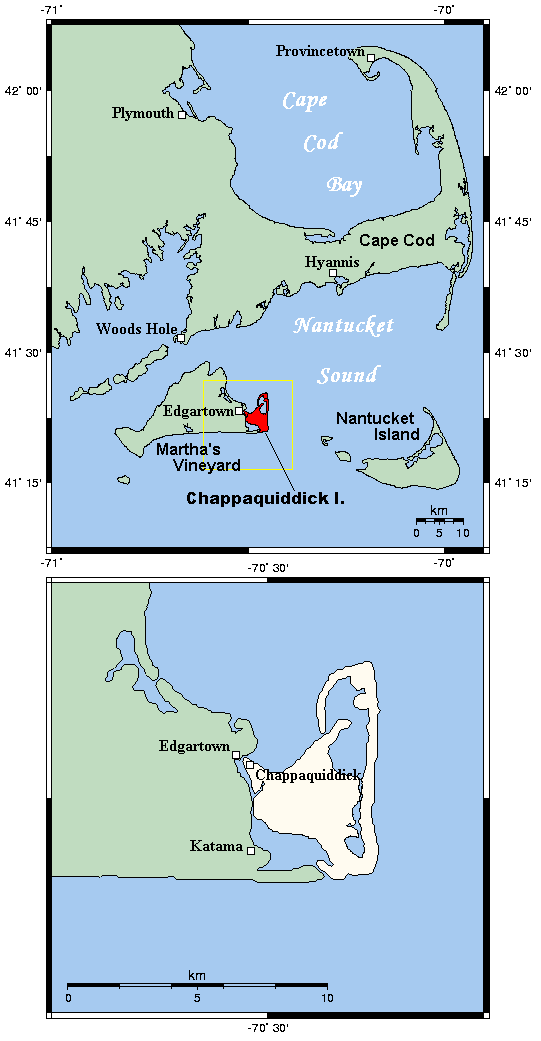
| DescriptionChappaquiddickmaps.png | a map of Chappaquiddick Island |
| Date | |
| Source | english WP |
| Author | english WP user en:User:Kelisi |

|
This locator map image could be re-created using vector graphics as an SVG file. This has several advantages; see Commons:Media for cleanup for more information. If an SVG form of this image is available, please upload it and afterwards replace this template with
{{vector version available|new image name}}.
It is recommended to name the SVG file “Chappaquiddickmaps.svg”—then the template Vector version available (or Vva) does not need the new image name parameter. |
Licensing

|
Permission is granted to copy, distribute and/or modify this document under the terms of the GNU Free Documentation License, Version 1.2 or any later version published by the Free Software Foundation; with no Invariant Sections, no Front-Cover Texts, and no Back-Cover Texts. A copy of the license is included in the section entitled GNU Free Documentation License.http://www.gnu.org/copyleft/fdl.htmlGFDLGNU Free Documentation Licensetruetrue |
| This file is licensed under the Creative Commons Attribution-Share Alike 3.0 Unported license. | ||
| ||
| This licensing tag was added to this file as part of the GFDL licensing update.http://creativecommons.org/licenses/by-sa/3.0/CC BY-SA 3.0Creative Commons Attribution-Share Alike 3.0truetrue |
en:Image:Chappaquiddickmaps.png
Original Description from en WP
Large-scale and small-scale maps of Chappaquiddick Island, Massachusetts. This map's source is here archive copy at the Wayback Machine, with the uploader's modifications, and the GMT homepage archive copy at the Wayback Machine says that the tools are released under the GNU General Public License.
Captions
Add a one-line explanation of what this file represents
Items portrayed in this file
depicts
10 September 2006
image/png
9f8e7e8e3b1289ec0f2d9964c69275fa7ca0f8a2
19,577 byte
1,041 pixel
541 pixel
File history
Click on a date/time to view the file as it appeared at that time.
| Date/Time | Thumbnail | Dimensions | User | Comment | |
|---|---|---|---|---|---|
| current | 18:06, 10 September 2006 | | 541 × 1,041 (19 KB) | Ranas~commonswiki | {{Information |Description=a map of Chappaquiddick Island |Source=english WP |Date=September 10, 2006 |Author=english WP user Kelisi |Permission= |other_versions= }} |
File usage
No pages on the English Wikipedia use this file (pages on other projects are not listed).
Global file usage
The following other wikis use this file:
- Usage on ceb.wikipedia.org
- Usage on cs.wikipedia.org
- Usage on de.wikipedia.org
- Usage on en.wikivoyage.org
- Usage on fi.wikipedia.org
- Usage on fr.wikipedia.org
- Usage on id.wikipedia.org
- Usage on it.wikipedia.org
- Usage on pt.wikipedia.org
- Usage on www.wikidata.org
Retrieved from "https://en.wikipedia.org/wiki/File:Chappaquiddickmaps.png"