File:DC_neighborhoods_map.png
From Wikipedia, the free encyclopedia
Size of this preview: 526 × 599 pixels. Other resolutions: 211 × 240 pixels | 421 × 480 pixels | 674 × 768 pixels | 899 × 1,024 pixels | 1,493 × 1,700 pixels.
Original file (1,493 × 1,700 pixels, file size: 1.52 MB, MIME type: image/png)
| This is a file from the Wikimedia Commons. Information from its description page there is shown below. Commons is a freely licensed media file repository. You can help. |
Summary
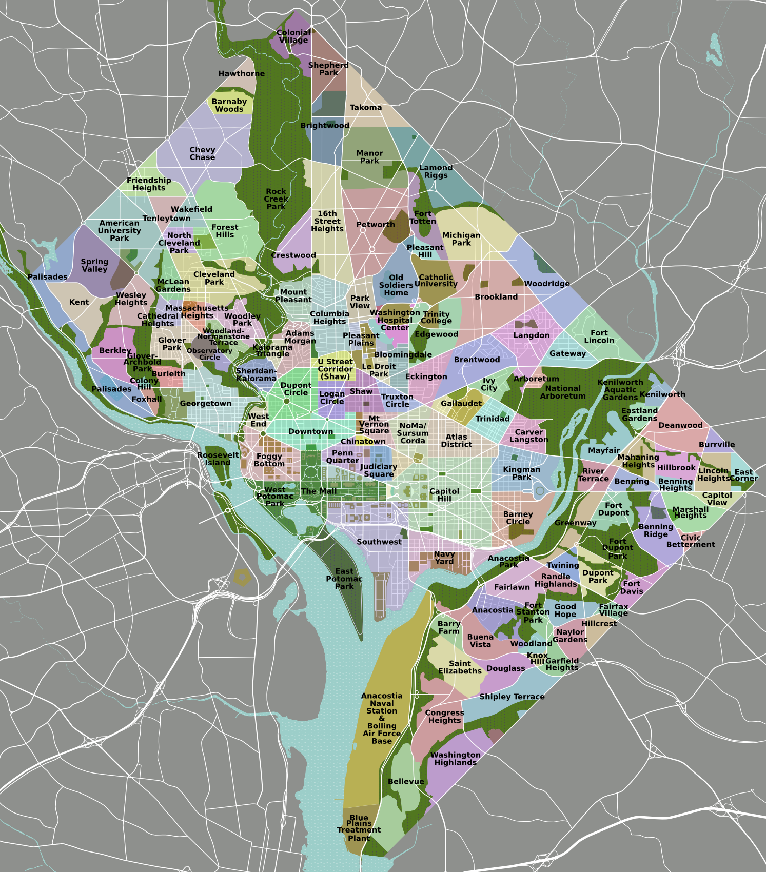
| DescriptionDC neighborhoods map.png | DC neighborhoods map |
| Date | |
| Source | self-made, tracing done from PD satellite imagery |
| Author | Peter Fitzgerald |
| Permission (Reusing this file) |
CC-by 3.0 |
| Other versions | SVG available on Wikitravel Shared, although it is not the current version, as Shared has a 8MB filesize limit... |
|
Need a higher resolution version? There's one available at File:DC neighborhoods map high res.png. (The thumbnail does not display images at such a high resolution—to access the file, click the "Full resolution" link [1] below the broken thumbnail.) |
Licensing
I, the copyright holder of this work, hereby publish it under the following license:
This file is licensed under the Creative Commons Attribution 3.0 Unported license.
- You are free:
- to share – to copy, distribute and transmit the work
- to remix – to adapt the work
- Under the following conditions:
- attribution – You must give appropriate credit, provide a link to the license, and indicate if changes were made. You may do so in any reasonable manner, but not in any way that suggests the licensor endorses you or your use.

|
This locator map image could be re-created using vector graphics as an SVG file. This has several advantages; see Commons:Media for cleanup for more information. If an SVG form of this image is available, please upload it and afterwards replace this template with
{{vector version available|new image name}}.
It is recommended to name the SVG file “DC neighborhoods map.svg”—then the template Vector version available (or Vva) does not need the new image name parameter. |
Captions
Add a one-line explanation of what this file represents
Items portrayed in this file
depicts
some value
22 February 2008
image/png
68d0f558def2931b424157def2ee82d748ab690c
1,597,401 byte
1,700 pixel
1,493 pixel
File history
Click on a date/time to view the file as it appeared at that time.
| Date/Time | Thumbnail | Dimensions | User | Comment | |
|---|---|---|---|---|---|
| current | 02:21, 2 September 2011 | | 1,493 × 1,700 (1.52 MB) | Peterfitzgerald | minor change |
| 02:15, 2 September 2011 |  | 1,493 × 1,700 (1.52 MB) | Peterfitzgerald | Lots of corrections and refinements | |
| 20:53, 4 January 2010 |  | 1,493 × 1,700 (1.5 MB) | Peterfitzgerald | split off Kalorama Triangle from Adams Morgan, adjusted Fairlawn & Randall Heights boundaries, & split off Spring Valley from American University Park | |
| 21:45, 30 January 2009 |  | 1,493 × 1,700 (1.53 MB) | Peterfitzgerald | too high res, it would seem | |
| 21:39, 30 January 2009 |  | 4,390 × 5,000 (5.66 MB) | Peterfitzgerald | increase resolution | |
| 14:32, 4 September 2008 |  | 1,493 × 1,700 (1.53 MB) | Peterfitzgerald | increase font size for better in-article readability | |
| 02:33, 21 April 2008 |  | 1,493 × 1,700 (1.43 MB) | Peterfitzgerald | a few fixes | |
| 17:10, 14 April 2008 |  | 1,493 × 1,700 (1.46 MB) | Peterfitzgerald | Separate Burleith from Georgetown | |
| 02:37, 23 February 2008 |  | 1,493 × 1,700 (1.41 MB) | Peterfitzgerald | {{Information |Description=DC neighborhoods map |Source=self-made, tracing done from PD satellite imagery |Date=22 February 2008 |Author= Peter Fitzgerald |Permission=CC-by-SA 3.0 |other_versions=SVG available on [http://wikitrave |
File usage
The following pages on the English Wikipedia use this file (pages on other projects are not listed):
Global file usage
The following other wikis use this file:
- Usage on de.wikipedia.org
- Usage on en.wikivoyage.org
- Usage on et.wikipedia.org
- Usage on frr.wikipedia.org
- Usage on ur.wikipedia.org
- Usage on vi.wikipedia.org
Retrieved from "https://en.wikipedia.org/wiki/File:DC_neighborhoods_map.png"