File:Europe_countries_map_en.png
From Wikipedia, the free encyclopedia
Size of this preview: 737 × 600 pixels. Other resolutions: 295 × 240 pixels | 590 × 480 pixels | 944 × 768 pixels | 1,259 × 1,024 pixels | 1,475 × 1,200 pixels.
Original file (1,475 × 1,200 pixels, file size: 612 KB, MIME type: image/png)
| This is a file from the Wikimedia Commons. Information from its description page there is shown below. Commons is a freely licensed media file repository. You can help. |
Summary
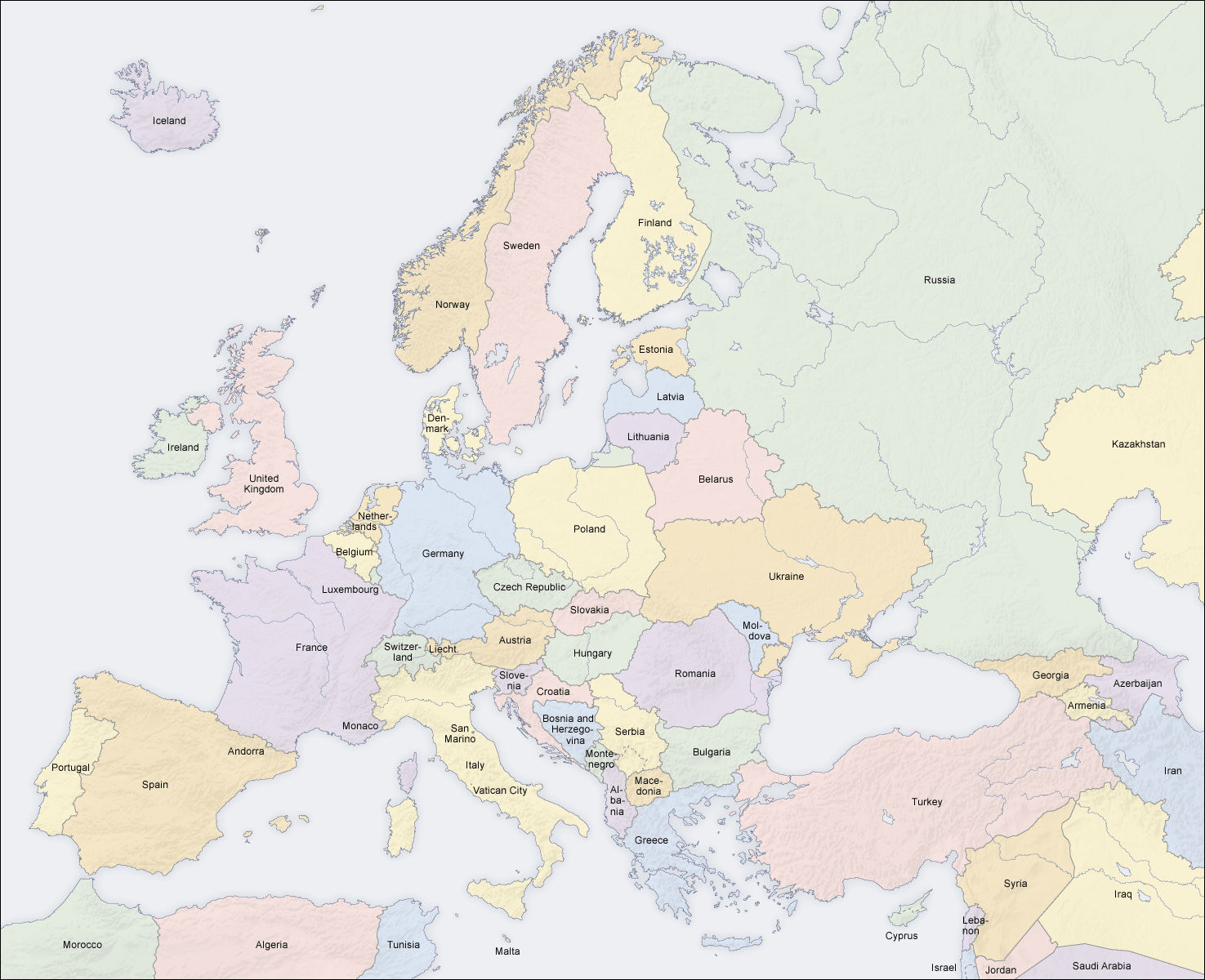
| DescriptionEurope countries map en.png |
English: Map of countries in Europe |
||||||||||
| Date | 02.04.2006 | ||||||||||
| Source | Own work (Original text: own map, based on the Generic Mapping Tools and ETOPO2) | ||||||||||
| Author | San Jose (map) | ||||||||||
| Permission (Reusing this file) |
|
||||||||||
| Other versions |
Derivative works of this file: [edit]
|


|
This map of europe image could be re-created using vector graphics as an SVG file. This has several advantages; see Commons:Media for cleanup for more information. If an SVG form of this image is available, please upload it and afterwards replace this template with
{{vector version available|new image name}}.
It is recommended to name the SVG file “Europe countries map en.svg”—then the template Vector version available (or Vva) does not need the new image name parameter. |
See also
_en.png)
.png)
.jpg)
Captions
Add a one-line explanation of what this file represents
Items portrayed in this file
depicts
File history
Click on a date/time to view the file as it appeared at that time.
| Date/Time | Thumbnail | Dimensions | User | Comment | |
|---|---|---|---|---|---|
| current | 14:49, 3 March 2018 | | 1,475 × 1,200 (612 KB) | Wiz9999 | Reverted to version as of 08:37, 12 June 2008 (UTC) - Please use File:Europe countries map en 2.png to show disputed land. |
| 17:07, 22 November 2017 |  | 1,475 × 1,200 (1.32 MB) | Мечников | update | |
| 08:37, 12 June 2008 |  | 1,475 × 1,200 (612 KB) | San Jose | update | |
| 11:52, 5 June 2006 |  | 1,475 × 1,200 (658 KB) | San Jose | updated and corrected | |
| 14:58, 4 June 2006 |  | 1,475 × 1,200 (611 KB) | Roke~commonswiki | montenegro independent now | |
| 11:14, 2 April 2006 |  | 1,475 × 1,200 (661 KB) | San Jose | Upload |
File usage
The following pages on the English Wikipedia use this file (pages on other projects are not listed):
Global file usage
The following other wikis use this file:
- Usage on da.wikipedia.org
- Usage on de.wikipedia.org
- Usage on haw.wikipedia.org
- Usage on he.wikipedia.org
- Usage on hyw.wikipedia.org
- Usage on ilo.wikipedia.org
- Usage on nl.wikinews.org
- Usage on pag.wikipedia.org
- Usage on roa-rup.wikipedia.org
- Usage on ro.wikipedia.org
- Usage on simple.wiktionary.org
- Usage on su.wikipedia.org
- Usage on ta.wikipedia.org
- Usage on uk.wikipedia.org
Metadata
This file contains additional information, probably added from the digital camera or scanner used to create or digitize it.
If the file has been modified from its original state, some details may not fully reflect the modified file.
| Software used |
|---|
Retrieved from "https://en.wikipedia.org/wiki/File:Europe_countries_map_en.png"