File:France_1812.png
From Wikipedia, the free encyclopedia
No higher resolution available.
France_1812.png (415 × 397 pixels, file size: 62 KB, MIME type: image/png)
| This is a file from the Wikimedia Commons. Information from its description page there is shown below. Commons is a freely licensed media file repository. You can help. |
Summary
| DescriptionFrance 1812.png |
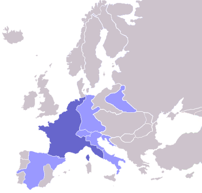
English: Map of the First French Empire in 1812, with the Empire in dark blue and satellite states in light blue. |
| Date |
17 October 2008 (original upload date) |
| Source | Own work (Original text: I created this work entirely by myself.) |
| Author | ZenCopain (talk) |

|
This historical map image could be re-created using vector graphics as an SVG file. This has several advantages; see Commons:Media for cleanup for more information. If an SVG form of this image is available, please upload it and afterwards replace this template with
{{vector version available|new image name}}.
It is recommended to name the SVG file “France 1812.svg”—then the template Vector version available (or Vva) does not need the new image name parameter. |
Licensing
| Public domainPublic domainfalsefalse |
| This work has been released into the public domain by its author, ZenCopain at English Wikipedia. This applies worldwide. In some countries this may not be legally possible; if so: ZenCopain grants anyone the right to use this work for any purpose, without any conditions, unless such conditions are required by law.Public domainPublic domainfalsefalse |
Original upload log
Transferred from en.wikipedia to Commons by Broadbeer using CommonsHelper.
The original description page was here. All following user names refer to en.wikipedia.
- 2008-10-17 22:16 ZenCopain 415×422× (13703 bytes) {{Information |Description= |Source=I created this work entirely by myself. |Date= [[2008]] |Author=~~~ |other_versions= }}
Captions
Add a one-line explanation of what this file represents
Items portrayed in this file
depicts
17 October 2008
image/png
File history
Click on a date/time to view the file as it appeared at that time.
| Date/Time | Thumbnail | Dimensions | User | Comment | |
|---|---|---|---|---|---|
| current | 17:33, 11 October 2022 | | 415 × 397 (62 KB) | Рагин1987 | Extended map |
| 15:21, 13 November 2008 |  | 415 × 422 (13 KB) | File Upload Bot (Magnus Manske) | {{BotMoveToCommons|en.wikipedia}} {{Information |Description={{en|Map of the First French Empire in 1812, with the Empire in dark blue and satellite states in light blue.}} |Source=Transferred from [http://en.wikipedia.org en.wikipedia]; transferred to C |
File usage
No pages on the English Wikipedia use this file (pages on other projects are not listed).
Metadata
This file contains additional information, probably added from the digital camera or scanner used to create or digitize it.
If the file has been modified from its original state, some details may not fully reflect the modified file.
| Horizontal resolution | 37.78 dpc |
|---|---|
| Vertical resolution | 37.78 dpc |
Retrieved from "https://en.wikipedia.org/wiki/File:France_1812.png"