File:Hoover-dam-contour-map.jpg
From Wikipedia, the free encyclopedia
Size of this preview: 800 × 305 pixels. Other resolutions: 320 × 122 pixels | 640 × 244 pixels | 1,520 × 580 pixels.
Original file (1,520 × 580 pixels, file size: 355 KB, MIME type: image/jpeg)
| This is a file from the Wikimedia Commons. Information from its description page there is shown below. Commons is a freely licensed media file repository. You can help. |
Summary
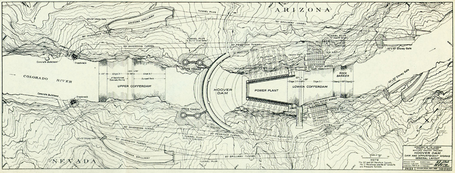
| DescriptionHoover-dam-contour-map.jpg |
English: Hoover Dam plan.
1930 |
| Date | |
| Source | U.S. Department of Interior, Bureau of Reclamation, Boulder Canyon Project, map. |
| Author | Mapmakers in employ of U.S. Department of Interior; signatures not readable. |
Licensing
| Public domainPublic domainfalsefalse |
This work is in the public domain in the United States because it is a work prepared by an officer or employee of the United States Government as part of that person’s official duties under the terms of Title 17, Chapter 1, Section 105 of the US Code.
Note: This only applies to original works of the Federal Government and not to the work of any individual U.S. state, territory, commonwealth, county, municipality, or any other subdivision. This template also does not apply to postage stamp designs published by the United States Postal Service since 1978. (See § 313.6(C)(1) of Compendium of U.S. Copyright Office Practices). It also does not apply to certain US coins; see The US Mint Terms of Use.
|
 | |
| This file has been identified as being free of known restrictions under copyright law, including all related and neighboring rights. | ||
https://creativecommons.org/publicdomain/mark/1.0/PDMCreative Commons Public Domain Mark 1.0falsefalse
Wikipedia upload log
An earlier Wikipedia description page is/was here. All following user names refer to en.wikipedia.
- 2006-11-18 02:35 Jsecure 1520×580× (363765 bytes) Freely available online item of historic interest
Captions
Add a one-line explanation of what this file represents
Items portrayed in this file
depicts
1930
File history
Click on a date/time to view the file as it appeared at that time.
| Date/Time | Thumbnail | Dimensions | User | Comment | |
|---|---|---|---|---|---|
| current | 12:10, 25 June 2010 | 1,520 × 580 (355 KB) | File Upload Bot (Magnus Manske) | {{BotMoveToCommons|en.wikipedia|year={{subst:CURRENTYEAR}}|month={{subst:CURRENTMONTHNAME}}|day={{subst:CURRENTDAY}}}} {{Information |Description={{en|Freely available online item of historic interest Dam, Hoover}} |S |
File usage
The following pages on the English Wikipedia use this file (pages on other projects are not listed):
Global file usage
The following other wikis use this file:
- Usage on ar.wikipedia.org
- Usage on en.wikibooks.org
- Usage on eo.wikipedia.org
- Usage on fr.wikipedia.org
- Usage on he.wikipedia.org
- Usage on hi.wikipedia.org
- Usage on hy.wikipedia.org
- Usage on it.wikipedia.org
- Usage on kn.wikipedia.org
- Usage on la.wikipedia.org
- Usage on ro.wikipedia.org
- Usage on te.wikipedia.org
- Usage on zh.wikipedia.org
Metadata
This file contains additional information, probably added from the digital camera or scanner used to create or digitize it.
If the file has been modified from its original state, some details may not fully reflect the modified file.
| _error | 0 |
|---|
Retrieved from "https://en.wikipedia.org/wiki/File:Hoover-dam-contour-map.jpg"