File:Justinian555AD.png
From Wikipedia, the free encyclopedia
Size of this preview: 800 × 434 pixels. Other resolutions: 320 × 173 pixels | 640 × 347 pixels | 1,024 × 555 pixels | 1,280 × 694 pixels | 2,111 × 1,144 pixels.
Original file (2,111 × 1,144 pixels, file size: 198 KB, MIME type: image/png)
| This is a file from the Wikimedia Commons. Information from its description page there is shown below. Commons is a freely licensed media file repository. You can help. |

|
This historical map image could be re-created using vector graphics as an SVG file. This has several advantages; see Commons:Media for cleanup for more information. If an SVG form of this image is available, please upload it and afterwards replace this template with
{{vector version available|new image name}}.
It is recommended to name the SVG file “Justinian555AD.svg”—then the template Vector version available (or Vva) does not need the new image name parameter. |
| Datasource (reference to visualized facts) is not provided for the data that is visualized in this self-made work. |
Summary
| DescriptionJustinian555AD.png |
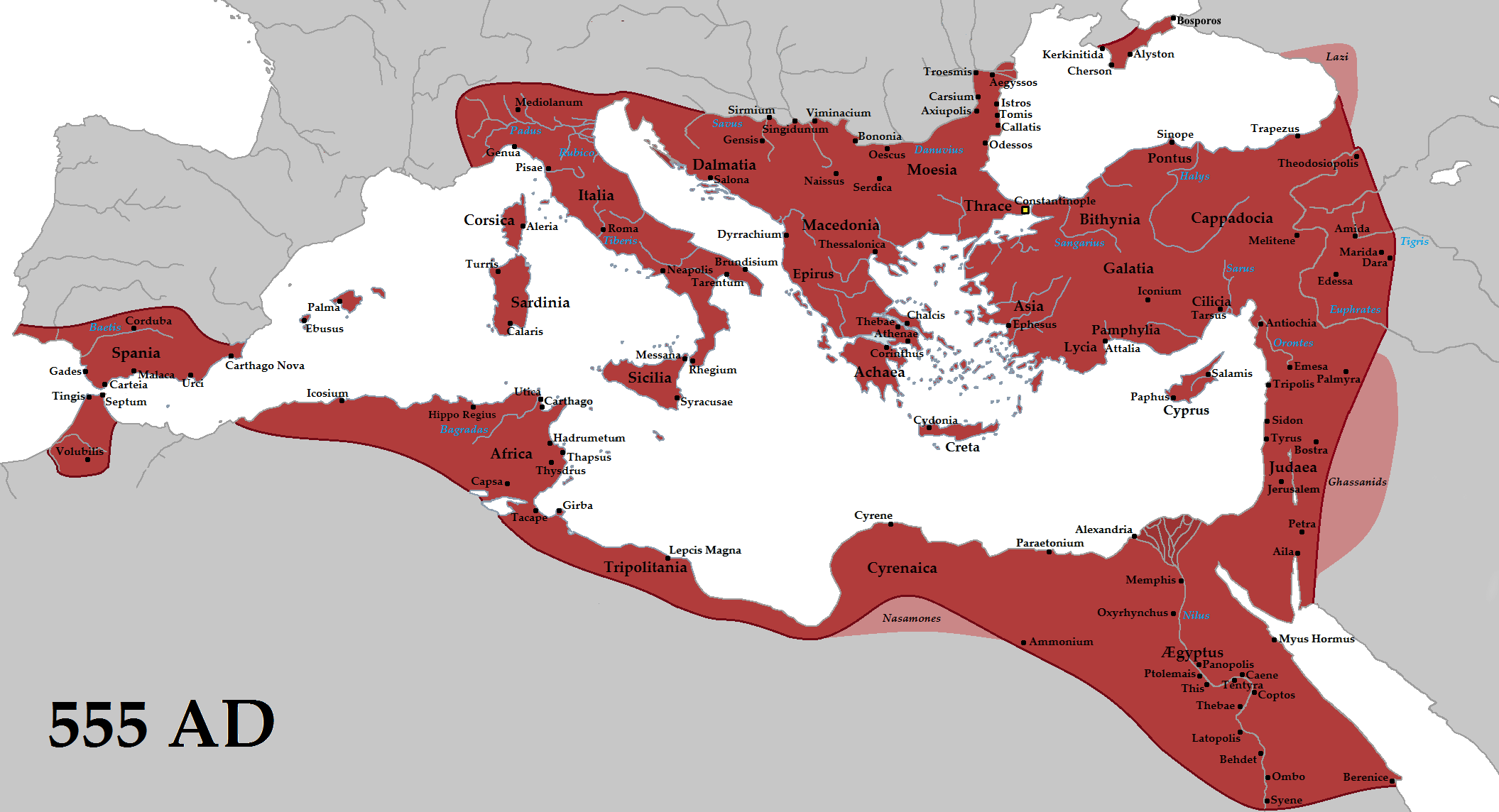
English: The Eastern Roman Empire (red) and its vassals (pink) in 555 AD during the reign of Justinian I. |
| Date | |
| Source | Own work |
| Author | Tataryn |
| Other versions | Arabic |
Licensing
I, the copyright holder of this work, hereby publish it under the following license:
This file is licensed under the Creative Commons Attribution-Share Alike 3.0 Unported license.
- You are free:
- to share – to copy, distribute and transmit the work
- to remix – to adapt the work
- Under the following conditions:
- attribution – You must give appropriate credit, provide a link to the license, and indicate if changes were made. You may do so in any reasonable manner, but not in any way that suggests the licensor endorses you or your use.
- share alike – If you remix, transform, or build upon the material, you must distribute your contributions under the same or compatible license as the original.
Captions
Byzantine Empire 555 AD
Oströmisches Reich (rot) und seine Vasallenstaaten (rosa) im Jahr 555 n.Chr. unter der Herrschaft von Justinian I.
MS 555 Doğu Roma (Bizans) Imparatorluğu
ബൈസന്റയ്ൻ സാമ്രാജ്യം (ക്രി.പി 555)
Византийская империя 555 год наша эра
ビザンティン帝国 西暦紀元555年
امپراتوری بیزانس در (زمان شهریاری ژوستینین یکم) سال ۵۵۵ پس از زایش
Império Bizantino 555 AD
Items portrayed in this file
depicts
16 June 2012
image/png
File history
Click on a date/time to view the file as it appeared at that time.
| Date/Time | Thumbnail | Dimensions | User | Comment | |
|---|---|---|---|---|---|
| current | 22:27, 11 March 2021 | | 2,111 × 1,144 (198 KB) | Gamerknowitall | Added the city of Bosporos. |
| 07:10, 10 February 2017 |  | 2,111 × 1,144 (216 KB) | Tataryn | Added Crimea area, more cities, fixed errors | |
| 01:36, 3 October 2015 |  | 2,111 × 1,144 (195 KB) | Tataryn | Added river labels | |
| 01:28, 3 October 2015 |  | 2,111 × 1,144 (191 KB) | Tataryn | Removed extra label | |
| 04:40, 25 September 2015 |  | 2,111 × 1,144 (192 KB) | Tataryn | Fixed eastern frontier, added cities | |
| 19:22, 10 June 2015 |  | 2,111 × 1,144 (146 KB) | Tataryn | cropped right side | |
| 19:16, 10 June 2015 |  | 2,260 × 1,144 (149 KB) | Tataryn | Added vassals | |
| 19:06, 10 June 2015 |  | 2,260 × 1,144 (147 KB) | Tataryn | Better quality, with cities | |
| 16:06, 10 August 2012 |  | 694 × 396 (13 KB) | DIREKTOR | Further | |
| 16:02, 10 August 2012 |  | 694 × 396 (13 KB) | DIREKTOR | Tyrian purple |
File usage
More than 100 pages use this file. The following list shows the first 100 pages that use this file only. A full list is available.
- Abbassus
- Acarassus
- Al-Athrun
- Algeria
- Alydda
- Anaua
- Androna
- Arabissus
- Archbishopric of Justiniana Prima
- Armenian Hexapolis
- Arneae
- Aulae (Cilicia)
- Bergule
- Berissa
- Byzantine Empire
- Caesaropolis
- Choma (Lycia)
- Christian state
- Chronology of warfare between the Romans and Germanic peoples
- Cidyessus
- Claudiopolis (Cappadocia)
- Colonia in Armenia
- Cybistra
- Cyprus (theme)
- Delkos
- Dimitri Kitsikis
- Diocese of Asia
- Diocese of Macedonia
- Diocese of Pontus
- Diocese of Thrace
- Dionysiopolis
- Doara
- Docimium
- Dometiopolis
- Empire
- Epiphania (Cilicia)
- Eukarpia
- Eulepa
- Eumeneia
- Faustinopolis
- Garius
- Germa (Galatia)
- Harbour of Eleutherios
- Hellenoturkism
- Heraclea Cybistra
- Hieria
- History of Corsica
- History of Turkey
- History of the Byzantine Empire
- Ibora
- Ipsus
- Isaura Nea
- Isaura Palaea
- Islands (Roman province)
- Justinianopolis (Galatia)
- Katepanikion
- Kolbasa
- Komnina, Kozani
- Korama
- List of Byzantine wars
- Lucania (theme)
- Malta
- Mesotymolus
- Middle Eastern empires
- Mokissos
- Morka
- Mossyna
- Mostene
- Motella
- Nazianzus
- Orcistus
- Orni
- Outline of ancient Rome
- Outline of the Byzantine Empire
- Padyandus
- Parlais
- Pegella
- Perateia
- Pogla
- Polybotus
- Roman–Iranian relations
- Sala (Lydia)
- Sasima
- Savatra
- Soterioupolis
- Southern Europe
- Syca
- Syria Prima
- Tabala (Lydia)
- Thebasa
- Themisonium
- Theodorias (province)
- Tracula
- Turkey
- Tymbrias
- White Wallachia
- Zenopolis (Lycia)
- Talk:Qing dynasty/Archive 5
- Talk:Tang dynasty
- User:Vitzque/byzantineottoman
View more links to this file.
Global file usage
The following other wikis use this file:
- Usage on af.wikipedia.org
- Usage on am.wikipedia.org
- Usage on ary.wikipedia.org
- Usage on ast.wikipedia.org
- Usage on azb.wikipedia.org
- Usage on az.wikipedia.org
- Usage on bar.wikipedia.org
- Usage on bcl.wikipedia.org
- Usage on be.wikipedia.org
- Usage on bg.wikipedia.org
- Usage on bxr.wikipedia.org
- Usage on ca.wikipedia.org
- Usage on co.wikipedia.org
- Usage on cs.wikipedia.org
- Usage on cy.wikipedia.org
- Usage on da.wikipedia.org
- Usage on de.wikipedia.org
- Usage on el.wikipedia.org
- Usage on en.wikibooks.org
- Usage on en.wikiversity.org
- Usage on en.wiktionary.org
- Usage on eo.wikipedia.org
- Usage on es.wikipedia.org
- Usage on et.wikipedia.org
View more global usage of this file.
Metadata
This file contains additional information, probably added from the digital camera or scanner used to create or digitize it.
If the file has been modified from its original state, some details may not fully reflect the modified file.
| Horizontal resolution | 37.8 dpc |
|---|---|
| Vertical resolution | 37.8 dpc |
Retrieved from "https://en.wikipedia.org/wiki/File:Justinian555AD.png"