File:Kainji_Lake_within_Nigeria.jpg
From Wikipedia, the free encyclopedia
Size of this preview: 779 × 599 pixels. Other resolutions: 312 × 240 pixels | 624 × 480 pixels | 954 × 734 pixels.
Original file (954 × 734 pixels, file size: 707 KB, MIME type: image/jpeg)
| This is a file from the Wikimedia Commons. Information from its description page there is shown below. Commons is a freely licensed media file repository. You can help. |
Summary
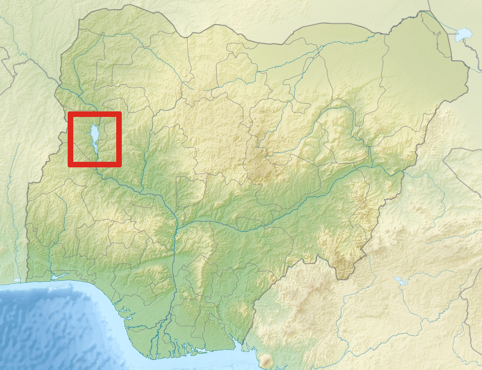
| DescriptionKainji Lake within Nigeria.jpg |
English: Relief location map of Nigeria. * Projection: Equirectangular projection, strechted by 100.0%. * Geographic limits of the map: :* N: 14.0° N :* S: 4.0° N :* W: 2.0° E :* E: 15.0° E * GMT projection: -JX16.154400000000003cd/12.42646153846154cd * GMT region: -R2.0/4.0/15.0/14.0r * GMT region for grdcut: -R2.0/4.0/15.0/14.0r * Relief: SRTM30plus. * Made with Natural Earth. Free vector and raster map data @ naturalearthdata.com. |
| Date | (UTC) |
| Source | |
| Author |
|
| This is a retouched picture, which means that it has been digitally altered from its original version. Modifications: highlighted Kainji lake. The original can be viewed here: Nigeria relief location map.jpg:
|
Licensing
I, the copyright holder of this work, hereby publish it under the following licenses:
This file is licensed under the Creative Commons Attribution-Share Alike 3.0 Unported license.
- You are free:
- to share – to copy, distribute and transmit the work
- to remix – to adapt the work
- Under the following conditions:
- attribution – You must give appropriate credit, provide a link to the license, and indicate if changes were made. You may do so in any reasonable manner, but not in any way that suggests the licensor endorses you or your use.
- share alike – If you remix, transform, or build upon the material, you must distribute your contributions under the same or compatible license as the original.

|
Permission is granted to copy, distribute and/or modify this document under the terms of the GNU Free Documentation License, Version 1.2 or any later version published by the Free Software Foundation; with no Invariant Sections, no Front-Cover Texts, and no Back-Cover Texts. A copy of the license is included in the section entitled GNU Free Documentation License.http://www.gnu.org/copyleft/fdl.htmlGFDLGNU Free Documentation Licensetruetrue |
You may select the license of your choice.
Original upload log
This image is a derivative work of the following images:
- File:Nigeria_relief_location_map.jpg licensed with Cc-by-sa-3.0, GFDL
- 2010-12-09T15:07:30Z Uwe Dedering 954x734 (665903 Bytes) initial upload
Uploaded with derivativeFX
Captions
Add a one-line explanation of what this file represents
Items portrayed in this file
depicts
1 December 2011
File history
Click on a date/time to view the file as it appeared at that time.
| Date/Time | Thumbnail | Dimensions | User | Comment | |
|---|---|---|---|---|---|
| current | 01:37, 1 December 2011 | | 954 × 734 (707 KB) | P. S. Burton | == {{int:filedesc}} == {{Information |Description={{en|1= Relief location map of Nigeria. * Projection: Equirectangular projection, strechted by 100.0%. * Geographic limits of the map: :* N: 14.0° N :* S: 4.0° N :* W: 2.0° E :* E: 15.0° E * GMT proj |
File usage
The following pages on the English Wikipedia use this file (pages on other projects are not listed):
Global file usage
The following other wikis use this file:
- Usage on ar.wikipedia.org
- Usage on ca.wikipedia.org
- Usage on da.wikipedia.org
- Usage on es.wikipedia.org
- Usage on ha.wikipedia.org
- Usage on id.wikipedia.org
- Usage on meta.wikimedia.org
- Usage on nn.wikipedia.org
- Usage on pl.wikipedia.org
- Usage on pt.wikipedia.org
- Usage on ru.wikipedia.org
- Usage on uk.wikipedia.org
- Usage on www.wikidata.org
Metadata
This file contains additional information, probably added from the digital camera or scanner used to create or digitize it.
If the file has been modified from its original state, some details may not fully reflect the modified file.
| Width | 954 px |
|---|---|
| Height | 734 px |
| Bits per component |
|
| Pixel composition | RGB |
| Orientation | Normal |
| Number of components | 3 |
| Horizontal resolution | 72 dpi |
| Vertical resolution | 72 dpi |
| Software used | Adobe Photoshop CS5.1 Macintosh |
| File change date and time | 02:33, 1 December 2011 |
| Exif version | 2.21 |
| Color space | Uncalibrated |
| Date and time of digitizing | 02:54, 1 December 2011 |
| Date metadata was last modified | 03:33, 1 December 2011 |
| Unique ID of original document | xmp.did:F77F11740720681197A5B7B66BEC2F46 |
Retrieved from "https://en.wikipedia.org/wiki/File:Kainji_Lake_within_Nigeria.jpg"