File:Karte_Hamburg_Innenstadtkanäle.png
From Wikipedia, the free encyclopedia
Size of this preview: 523 × 599 pixels. Other resolutions: 210 × 240 pixels | 419 × 480 pixels | 671 × 768 pixels | 894 × 1,024 pixels | 1,764 × 2,020 pixels.
Original file (1,764 × 2,020 pixels, file size: 773 KB, MIME type: image/png)
| This is a file from the Wikimedia Commons. Information from its description page there is shown below. Commons is a freely licensed media file repository. You can help. |
Summary
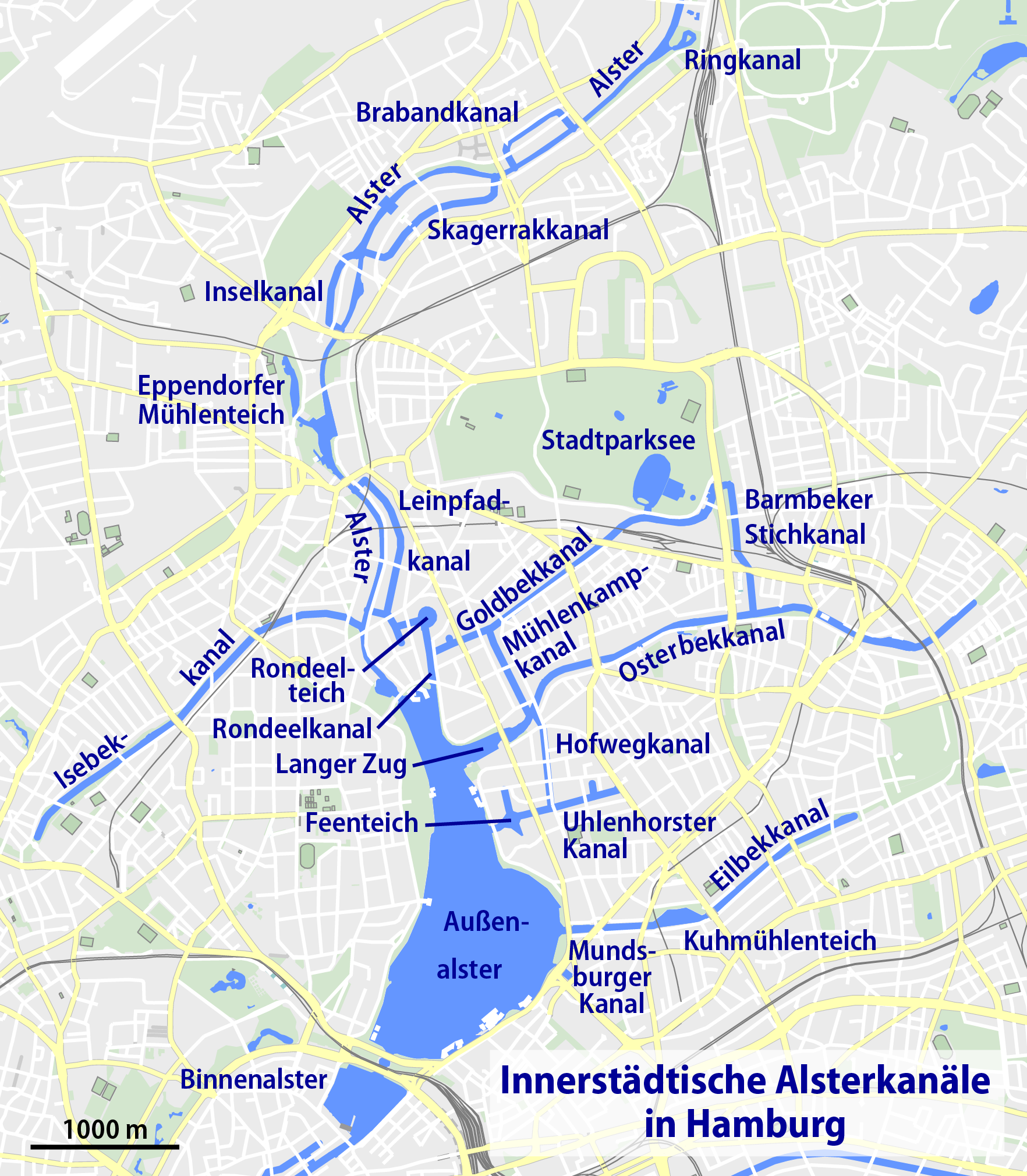
| DescriptionKarte Hamburg Innenstadtkanäle.png |
Deutsch: Karte der innerstädtischen Kanäle von Hamburg
English: Map of canals in Hamburg |
| Date | |
| Source | Own work |
| Author | NordNordWest |
| Other versions |
 |

|
This map has been made or improved in the German Kartenwerkstatt (Map Lab). You can propose maps to improve as well.
azərbaycanca ∙ čeština ∙ Deutsch ∙ Deutsch (Sie-Form) ∙ English ∙ español ∙ français ∙ italiano ∙ latviešu ∙ magyar ∙ Nederlands ∙ Plattdüütsch ∙ polski ∙ português ∙ română ∙ sicilianu ∙ slovenščina ∙ suomi ∙ македонски ∙ русский ∙ ქართული ∙ հայերեն ∙ বাংলা ∙ ไทย ∙ +/−
|
Licensing
| DescriptionKarte Hamburg Innenstadtkanäle.png |
This map was created from OpenStreetMap project data, collected by the community. This map may be incomplete, and may contain errors. Don't rely solely on it for navigation. |
| Date | (see file history) |
| Source | openstreetmap.org |
| Creator |
OpenStreetMap contributors |
| Permission (Reusing this file) |
OpenStreetMap data and maps are licensed under the Creative Commons Attribution-ShareAlike 2.0 license (CC-BY-SA 2.0). This file is licensed under the Creative Commons Attribution-Share Alike 2.0 Generic license.
|
| Georeferencing | Georeference the map in Wikimaps Warper If inappropriate please set warp_status = skip to hide. |
Captions
Add a one-line explanation of what this file represents
Items portrayed in this file
depicts
some value
28 July 2009
File history
Click on a date/time to view the file as it appeared at that time.
| Date/Time | Thumbnail | Dimensions | User | Comment | |
|---|---|---|---|---|---|
| current | 14:38, 10 January 2020 | | 1,764 × 2,020 (773 KB) | NordNordWest | upd |
| 22:47, 22 May 2014 |  | 1,160 × 1,331 (827 KB) | Ras67 | cropped, ECI-RGB profile preserved | |
| 16:12, 1 February 2011 |  | 1,176 × 1,347 (829 KB) | NordNordWest | upd | |
| 16:48, 29 July 2009 |  | 1,183 × 1,354 (468 KB) | NordNordWest | ||
| 20:31, 28 July 2009 |  | 1,183 × 1,354 (468 KB) | NordNordWest | ||
| 19:55, 28 July 2009 |  | 1,183 × 1,354 (468 KB) | NordNordWest | {{Information |Description= {{de|Karte der innerstädtischen Kanäle von Hamburg}} {{en|Map of canals in Hamburg}} |Source={{Own}} |Date=2009-07-28 |Author={{U|NordNordWest}} |Permission={{OpenStreetMap}} |other_versions= |
File usage
The following pages on the English Wikipedia use this file (pages on other projects are not listed):
Global file usage
The following other wikis use this file:
- Usage on af.wikipedia.org
- Usage on arz.wikipedia.org
- Usage on ca.wikipedia.org
- Usage on da.wikipedia.org
- Usage on de.wikipedia.org
- Isebekkanal
- Osterbek
- Goldbekkanal
- Kanäle in Hamburg
- Leinpfadkanal
- Wikipedia:Kartenwerkstatt/Archiv/2009-07
- Rondeelteich
- Barmbeker Stichkanal
- Benutzer:Aeroid/List DE HH-unmittelbar
- Benutzer:UweRohwedder/hhmaps
- Brabandkanal
- Skagerrakkanal
- Uhlenhorster Kanal
- Wikipedia:Kontor Hamburg/Kanäle
- Inselkanal
- Feenteich
- Rondeelkanal
- Mühlenkampkanal
- Usage on mk.wikipedia.org
- Usage on sr.wikipedia.org
- Usage on www.wikidata.org
Metadata
This file contains additional information, probably added from the digital camera or scanner used to create or digitize it.
If the file has been modified from its original state, some details may not fully reflect the modified file.
| Horizontal resolution | 118.11 dpc |
|---|---|
| Vertical resolution | 118.11 dpc |
| Software used |