File:Karte_Niedersaechsisches_Bergland.jpg
From Wikipedia, the free encyclopedia
Size of this preview: 800 × 545 pixels. Other resolutions: 320 × 218 pixels | 640 × 436 pixels | 1,024 × 697 pixels | 1,420 × 967 pixels.
Original file (1,420 × 967 pixels, file size: 964 KB, MIME type: image/jpeg)
| This is a file from the Wikimedia Commons. Information from its description page there is shown below. Commons is a freely licensed media file repository. You can help. |
Summary
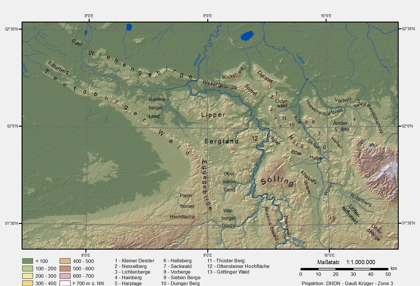
| DescriptionKarte Niedersaechsisches Bergland.jpg |
Karte des Niedersächsischen Berglandes (Lower Saxony mountain region). Datengrundlage:
Projektion/Koordinaten:
|
| Date | 6 January 2006 (original upload date) |
| Source | No machine-readable source provided. Own work assumed (based on copyright claims). |
| Author | No machine-readable author provided. Langläufer assumed (based on copyright claims). |
Andere Versionen
Same picture without text and frame (available only in German Wikipedia)
Licensing
| Public domainPublic domainfalsefalse |
| I, the copyright holder of this work, release this work into the public domain. This applies worldwide. In some countries this may not be legally possible; if so: I grant anyone the right to use this work for any purpose, without any conditions, unless such conditions are required by law. |
Captions
Add a one-line explanation of what this file represents
Items portrayed in this file
depicts
6 January 2006
File history
Click on a date/time to view the file as it appeared at that time.
| Date/Time | Thumbnail | Dimensions | User | Comment | |
|---|---|---|---|---|---|
| current | 13:06, 24 February 2009 | | 1,420 × 967 (964 KB) | Langläufer | rechtschreibfix |
| 11:36, 6 February 2006 |  | 1,422 × 968 (530 KB) | Langläufer | weißer Hintergrund, 150dpi Auflösung | |
| 17:07, 13 January 2006 |  | 948 × 645 (267 KB) | Langläufer | correction of vorberge/sackwald, new legend | |
| 15:38, 12 January 2006 |  | 948 × 652 (292 KB) | Langläufer | scale, projection, legend | |
| 23:38, 6 January 2006 |  | 1,013 × 632 (284 KB) | Langläufer | Karte Niedersächsisches Bergland Basiert auf SRTM-Daten |
File usage
The following pages on the English Wikipedia use this file (pages on other projects are not listed):
Global file usage
The following other wikis use this file:
- Usage on arz.wikipedia.org
- Usage on azb.wikipedia.org
- Usage on bg.wikipedia.org
- Usage on ceb.wikipedia.org
- Usage on da.wikipedia.org
- Usage on de.wikipedia.org
- Solling
- Bramwald
- Reinhardswald
- Paderborner Hochfläche
- Benutzer:Langläufer
- Niedersächsisches Bergland
- Datei:Karte Niedersaechsisches Bergland ohne Namen.jpg
- Datei:Niedersaechsiches-Bergland-topographisch.png
- Benutzer:Ulflulfl/Karten
- Benutzer:Thombansen/Artikel in Überarbeitung 1
- Benutzer:Virtualiter/Baustelle2
- Göttingen-Northeimer Wald
- Diskussion:Wallburgen der Latènezeit in Westfalen-Lippe
- Benutzer:Aeroid/List DE NI-HOL
- Benutzer:Aeroid/List DE NI-NOM
- Benutzer:Aeroid/List DE NI Natural region
- Benutzer Diskussion:TUBS/Archiv/2008
- Usage on de.wikivoyage.org
- Usage on eo.wikipedia.org
- Usage on es.wikipedia.org
- Usage on et.wikipedia.org
- Usage on fr.wikipedia.org
- Usage on fy.wikipedia.org
- Usage on it.wikipedia.org
- Usage on it.wikivoyage.org
- Usage on ja.wikipedia.org
- Usage on lld.wikipedia.org
- Usage on mk.wikipedia.org
- Usage on nds.wikipedia.org
- Usage on nl.wikipedia.org
- Usage on no.wikipedia.org
View more global usage of this file.
Metadata
This file contains additional information, probably added from the digital camera or scanner used to create or digitize it.
If the file has been modified from its original state, some details may not fully reflect the modified file.
| _error | 0 |
|---|