File:Livingston-Island-Map-2010-15.png
From Wikipedia, the free encyclopedia
Size of this preview: 799 × 600 pixels. Other resolutions: 320 × 240 pixels | 640 × 480 pixels | 1,023 × 768 pixels | 1,280 × 961 pixels | 2,560 × 1,922 pixels | 5,337 × 4,006 pixels.
Original file (5,337 × 4,006 pixels, file size: 9.65 MB, MIME type: image/png)
| This is a file from the Wikimedia Commons. Information from its description page there is shown below. Commons is a freely licensed media file repository. You can help. |
Summary
| DescriptionLivingston-Island-Map-2010-15.png |
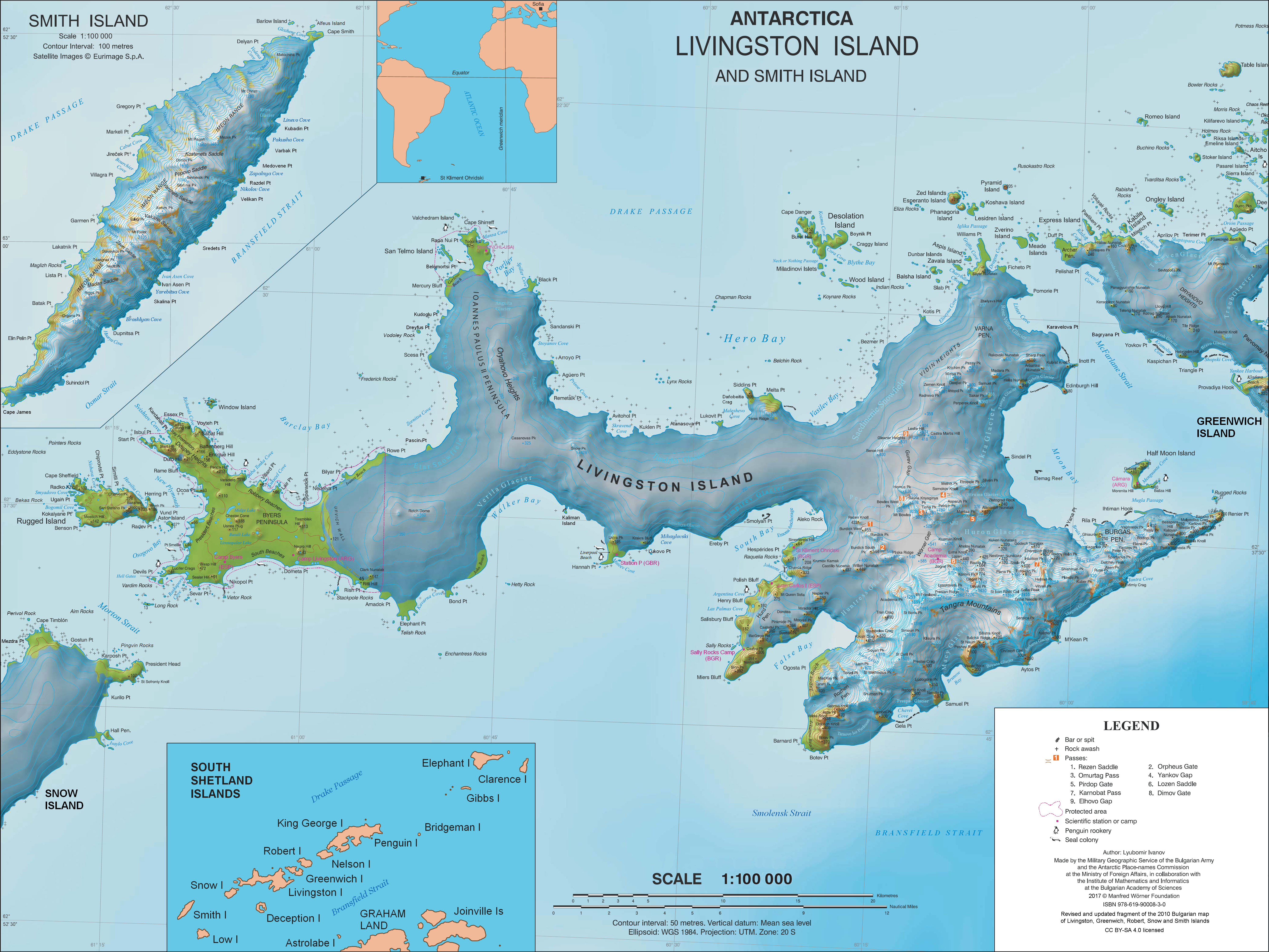
English: L.L. Ivanov. Antarctica: Livingston Island and Smith Island. Scale 1:100000 topographic map. Manfred Wörner Foundation, 2017. ISBN 978-619-90008-3-0 |
| Date | |
| Source | Own work |
| Author | Apcbg |
| Permission (Reusing this file) |
Published by the Manfred Wörner Foundation under the Creative Commons Attribution ShareAlike 4.0 license. |
| Other versions | File:Livingston-Island-Map-2010.jpg, an earlier version |
Licensing
I, the copyright holder of this work, hereby publish it under the following license:
This file is licensed under the Creative Commons Attribution-Share Alike 4.0 International license.
- You are free:
- to share – to copy, distribute and transmit the work
- to remix – to adapt the work
- Under the following conditions:
- attribution – You must give appropriate credit, provide a link to the license, and indicate if changes were made. You may do so in any reasonable manner, but not in any way that suggests the licensor endorses you or your use.
- share alike – If you remix, transform, or build upon the material, you must distribute your contributions under the same or compatible license as the original.
Captions
Topographic map of Livingston Island and Smith Island, Antarctica
Items portrayed in this file
depicts
31 March 2017
image/png
File history
Click on a date/time to view the file as it appeared at that time.
| Date/Time | Thumbnail | Dimensions | User | Comment | |
|---|---|---|---|---|---|
| current | 10:28, 2 April 2021 | | 5,337 × 4,006 (9.65 MB) | Apcbg | update |
| 13:21, 27 June 2019 |  | 5,337 × 4,006 (9.65 MB) | Apcbg | minor update | |
| 12:21, 23 May 2019 |  | 5,337 × 4,006 (9.65 MB) | Apcbg | update | |
| 08:22, 19 March 2019 |  | 5,337 × 4,006 (9.65 MB) | Apcbg | minor update | |
| 21:14, 9 February 2019 |  | 5,337 × 4,006 (9.66 MB) | Apcbg | Update | |
| 15:35, 5 February 2019 |  | 5,337 × 4,006 (9.66 MB) | Apcbg | Minor | |
| 19:20, 2 February 2019 |  | 5,337 × 4,006 (9.66 MB) | Apcbg | Update | |
| 06:44, 9 August 2018 |  | 5,337 × 4,006 (9.66 MB) | Apcbg | Update | |
| 06:17, 8 August 2018 |  | 5,337 × 4,006 (9.66 MB) | Apcbg | Update | |
| 11:38, 31 March 2017 |  | 5,337 × 4,006 (10.92 MB) | Apcbg | Updated topography and toponymy |
File usage
More than 100 pages use this file. The following list shows the first 100 pages that use this file only. A full list is available.
- Academia Peak
- Amadok Point
- Arbanasi Nunatak
- Arkutino Beach
- Atanasoff Nunatak
- Atlantic Club Ridge
- Beroe Hill
- Boyana Glacier
- Bulgarian Beach
- Canetti Peak
- Catalunyan Saddle
- Charrúa Gap
- Debelt Glacier
- Delchev Peak
- Dobrich Knoll
- Dobrudzha Glacier
- Dospat Peak
- Elena Peak
- Eliseyna Cove
- Emona Anchorage
- Erma Knoll
- Etar Snowfield
- Friesland Ridge
- Gabrovo Knoll
- Ghiaurov Peak
- Hesperides Hill
- Intuition Peak
- Ioannes Paulus II Peninsula
- Iskar Glacier
- Kaloyan Nunatak
- Kamchiya Glacier
- Kardam Buttress
- Kavarna Cove
- Krakra Bluff
- Kresna Gully
- Krum Rock
- Kuber Peak
- Kukeri Nunataks
- Kuzman Knoll
- Levski Ridge
- Livingston Island
- Lyaskovets Peak
- Lyulin Peak
- Magura Glacier
- Maritsa Peak
- Medven Glacier
- Melnik Peak
- Melnik Ridge
- Melta Point
- Mesta Peak
- Miziya Peak
- Montana Bluff
- Murgash Glacier
- Musala Glacier
- Nesebar Gap
- Nestinari Nunataks
- Nikopol Point
- Ogosta Point
- Ongal Peak
- Orpheus Gate
- Oryahovo Heights
- Osogovo Bay
- Paisiy Peak
- Panega Glacier
- Pautalia Glacier
- Perperek Knoll
- Perunika Glacier
- Peshev Ridge
- Peshtera Glacier
- Petko Voyvoda Peak
- Pimpirev Glacier
- Pliska Ridge
- Plovdiv Peak
- Pomorie Point
- Presian Ridge
- Prespa Glacier
- Radnevo Peak
- Radomir Knoll
- Radoy Ralin Peak
- Ravda Peak
- Rayna Knyaginya Peak
- Remetalk Point
- Rezen Saddle
- Rezovski Creek
- Rila Point
- Rongel Point
- Ropotamo Glacier
- Rose Valley Glacier
- Rozhen Peninsula
- Rugged Island (South Shetland Islands)
- Saedinenie Snowfield
- Sea Lion Glacier
- Sea Lion Tarn
- Serdica Peak
- Shipka Saddle
- Shishman Peak
- Shopski Cove
- Shumen Peak
- Simeon Peak
- Sinemorets Hill
View more links to this file.
Global file usage
The following other wikis use this file:
- Usage on ar.wikipedia.org
- Usage on ast.wikipedia.org
- Usage on az.wikipedia.org
- Usage on bg.wikipedia.org
- Свети Климент Охридски (база)
- Ливингстън (остров)
- Тангра (планина)
- Монтана (връх)
- Академия (връх)
- Айтос (нос)
- Авитохол (нос)
- Цариград (връх)
- Лясковец (връх)
- Фрисланд (връх)
- Видински възвишения
- Куцото куче
- Свети Борис (връх)
- Симеон (връх)
- Варна (полуостров)
- Свети Иван Рилски (рид)
- Потребител:Dafosaddikk/Скала Белчин
- Скала Белчин
- Usage on ca.wikipedia.org
- Usage on ceb.wikipedia.org
- Usage on de.wikipedia.org
- Livingston-Insel
- Table Island (Südliche Shetlandinseln)
- Barclay Bay
- Kap Shirreff
- Johannes-Paul-II.-Halbinsel
- Hero Bay
- Desolation Island (Südliche Shetlandinseln)
- Burdick Peak
- Black Point (Livingston-Insel)
- Blythe Bay
- Hemus Peak
- Leslie Hill (Livingston-Insel)
- Brunow Bay
- Bravo-Gletscher
- McFarlane Strait
- Renier Point
- Burdick South Peak
- Burdick West Peak
- Willan-Nunatak
- Plíska Ridge
- Rotch Dome
- Cora Cove
- Craggy Island (Südliche Shetlandinseln)
View more global usage of this file.
Metadata
This file contains additional information, probably added from the digital camera or scanner used to create or digitize it.
If the file has been modified from its original state, some details may not fully reflect the modified file.
| Horizontal resolution | 37.8 dpc |
|---|---|
| Vertical resolution | 37.8 dpc |
| Software used |
Retrieved from "https://en.wikipedia.org/wiki/File:Livingston-Island-Map-2010-15.png"