File:Lot_map.PNG
From Wikipedia, the free encyclopedia
Lot_map.PNG (270 × 407 pixels, file size: 6 KB, MIME type: image/png)
| This is a file from the Wikimedia Commons. Information from its description page there is shown below. Commons is a freely licensed media file repository. You can help. |
Summary
| DescriptionLot map.PNG |
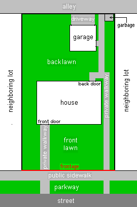
Diagram of an example house Lot as seen from above, showing front and back yards, positions of structures on the lot, and immediate surroundings. The lot boundaries are outlined in black except for the frontage, which is shown in red. In this example, the immediate surroundings include a sidewalk, parkway, and section of street out in front and a section of alley in back. Lot structures include a house, private walkways, and in back - a detached garage with driveway access to the alley and an a small area for garbage. H Padleckas created this image file in early September 2006 especially for use in the article "Lot (real estate)" in Wikipedia. H Padleckas 11:22, 16 September 2006 (UTC) |
| Date | 16 September 2006 (original upload date) |
| Source | No machine-readable source provided. Own work assumed (based on copyright claims). |
| Author | No machine-readable author provided. H Padleckas assumed (based on copyright claims). |
Licensing
- You are free:
- to share – to copy, distribute and transmit the work
- to remix – to adapt the work
- Under the following conditions:
- attribution – You must give appropriate credit, provide a link to the license, and indicate if changes were made. You may do so in any reasonable manner, but not in any way that suggests the licensor endorses you or your use.
- share alike – If you remix, transform, or build upon the material, you must distribute your contributions under the same or compatible license as the original.
Captions
Items portrayed in this file
depicts
16 September 2006
File history
Click on a date/time to view the file as it appeared at that time.
| Date/Time | Thumbnail | Dimensions | User | Comment | |
|---|---|---|---|---|---|
| current | 02:32, 15 May 2013 | | 270 × 407 (6 KB) | Nyttend | Language-neutral wording; "yard" has different meanings in the UK and USA, but everyone uses "lawn" to refer to grassy areas. |
| 11:15, 16 September 2006 |  | 270 × 407 (8 KB) | H Padleckas | Diagram of house Lot as seen from above |
File usage
Global file usage
The following other wikis use this file:
- Usage on en.wiktionary.org
- Usage on fa.wikipedia.org
- Usage on he.wikipedia.org
- Usage on id.wikipedia.org
- Usage on ro.wikipedia.org
- Usage on simple.wiktionary.org
Metadata
This file contains additional information, probably added from the digital camera or scanner used to create or digitize it.
If the file has been modified from its original state, some details may not fully reflect the modified file.
| Horizontal resolution | 37.8 dpc |
|---|---|
| Vertical resolution | 37.8 dpc |