File:LouisianaPurchase.png
From Wikipedia, the free encyclopedia
Size of this preview: 800 × 493 pixels. Other resolutions: 320 × 197 pixels | 640 × 395 pixels | 1,024 × 632 pixels | 1,456 × 898 pixels.
Original file (1,456 × 898 pixels, file size: 295 KB, MIME type: image/png)
| This is a file from the Wikimedia Commons. Information from its description page there is shown below. Commons is a freely licensed media file repository. You can help. |

|
This historical map image could be re-created using vector graphics as an SVG file. This has several advantages; see Commons:Media for cleanup for more information. If an SVG form of this image is available, please upload it and afterwards replace this template with
{{vector version available|new image name}}.
It is recommended to name the SVG file “LouisianaPurchase.svg”—then the template Vector version available (or Vva) does not need the new image name parameter. |
Summary
| DescriptionLouisianaPurchase.png |
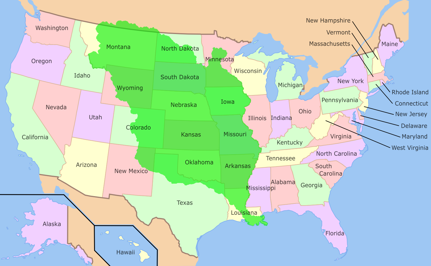
English: The Louisiana Purchase of 1803 Deutsch: Das durch den Louisiana Purchase erworbene Gebiet |
||
| Date | |||
| Source | Image:Map of USA showing state names.png | ||
| Author | Benutzer:ErnstA (Ernst Schütte) | ||
| PNG development InfoField |
|
Licensing

|
Permission is granted to copy, distribute and/or modify this document under the terms of the GNU Free Documentation License, Version 1.2 or any later version published by the Free Software Foundation; with no Invariant Sections, no Front-Cover Texts, and no Back-Cover Texts. A copy of the license is included in the section entitled GNU Free Documentation License.http://www.gnu.org/copyleft/fdl.htmlGFDLGNU Free Documentation Licensetruetrue |
| This file is licensed under the Creative Commons Attribution-Share Alike 3.0 Unported license. | ||
| ||
| This licensing tag was added to this file as part of the GFDL licensing update.http://creativecommons.org/licenses/by-sa/3.0/CC BY-SA 3.0Creative Commons Attribution-Share Alike 3.0truetrue |
Original upload log
from de:wiki (User de:Benutzer:ErnstA
- Beschreibung: Das durch den Louisiana Purchase erworbene Gebiet
- Quelle: Image:Map of USA showing state names.png bearbeitet, 12.10.2004
- Fotograf oder Zeichner: Ernst Schütte
first upload in de wikipedia on 17:46, 12. Okt 2004 by ErnstA
Captions
Louisiana Purchase
Louisiana Purchase
Items portrayed in this file
depicts
12 October 2004
image/png
File history
Click on a date/time to view the file as it appeared at that time.
| Date/Time | Thumbnail | Dimensions | User | Comment | |
|---|---|---|---|---|---|
| current | 00:16, 20 October 2022 | | 1,456 × 898 (295 KB) | Ras67 | cropped and optimized |
| 01:50, 16 May 2006 |  | 1,480 × 906 (357 KB) | Sting | Bigger map; borders correction : + part in Canada, - part in the South-East | |
| 22:49, 3 June 2005 |  | 800 × 495 (130 KB) | Manutius | {{gfdl}} from de:wiki (User de:Benutzer:ErnstA |
File usage
The following pages on the English Wikipedia use this file (pages on other projects are not listed):
Global file usage
The following other wikis use this file:
- Usage on ang.wikipedia.org
- Usage on ar.wikipedia.org
- Usage on azb.wikipedia.org
- Usage on bn.wikipedia.org
- Usage on br.wikipedia.org
- Usage on ca.wikipedia.org
- Usage on cs.wikipedia.org
- Usage on da.wikipedia.org
- Usage on de.wikipedia.org
- Usage on es.wikipedia.org
- Usage on et.wikipedia.org
- Usage on fi.wikipedia.org
- Usage on fr.wikipedia.org
- Usage on fr.wikibooks.org
- Usage on gl.wikipedia.org
- Usage on he.wikipedia.org
- Usage on id.wikipedia.org
- Usage on io.wikipedia.org
- Usage on it.wikipedia.org
- Usage on ko.wikipedia.org
- Usage on nds.wikipedia.org
- Usage on no.wikipedia.org
View more global usage of this file.
Metadata
This file contains additional information, probably added from the digital camera or scanner used to create or digitize it.
If the file has been modified from its original state, some details may not fully reflect the modified file.
| Software used |
|---|
Retrieved from "https://en.wikipedia.org/wiki/File:LouisianaPurchase.png"