File:Panama_Canal_Map_FR.png
From Wikipedia, the free encyclopedia
Size of this preview: 581 × 600 pixels. Other resolutions: 232 × 240 pixels | 465 × 480 pixels | 744 × 768 pixels | 992 × 1,024 pixels | 2,191 × 2,262 pixels.
Original file (2,191 × 2,262 pixels, file size: 3.5 MB, MIME type: image/png)
| This is a file from the Wikimedia Commons. Information from its description page there is shown below. Commons is a freely licensed media file repository. You can help. |
Summary
| DescriptionPanama Canal Map FR.png |
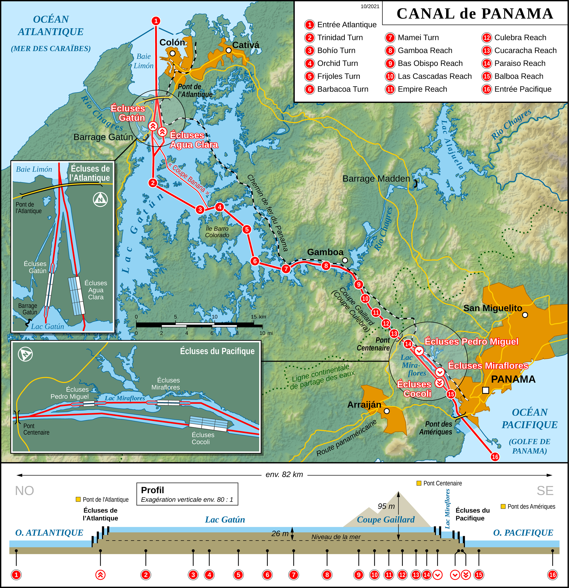
English: Map of the Panama Canal (French version)
Français : Carte du Canal de Panama (Version française)
Deutsch: Karte des Panamakanals (Französische Version) |
| Date | |
| Source |
Own work Map created using: |
| Author | Thoroe |
| Permission (Reusing this file) |
Map data (c) OpenStreetMap (and) contributors, CC-BY-SA |
| Other versions |
[edit]
|


|
This map has been made or improved in the German Kartenwerkstatt (Map Lab). You can propose maps to improve as well.
azərbaycanca ∙ čeština ∙ Deutsch ∙ Deutsch (Sie-Form) ∙ English ∙ español ∙ français ∙ italiano ∙ latviešu ∙ magyar ∙ Nederlands ∙ Plattdüütsch ∙ polski ∙ português ∙ română ∙ sicilianu ∙ slovenščina ∙ suomi ∙ македонски ∙ русский ∙ ქართული ∙ հայերեն ∙ বাংলা ∙ ไทย ∙ +/−
|
Licensing
This file is licensed under the Creative Commons Attribution-Share Alike 2.0 Generic license.
Attribution: Thomas Römer/OpenStreetMap data
- You are free:
- to share – to copy, distribute and transmit the work
- to remix – to adapt the work
- Under the following conditions:
- attribution – You must give appropriate credit, provide a link to the license, and indicate if changes were made. You may do so in any reasonable manner, but not in any way that suggests the licensor endorses you or your use.
- share alike – If you remix, transform, or build upon the material, you must distribute your contributions under the same or compatible license as the original.
Captions
Add a one-line explanation of what this file represents
Items portrayed in this file
depicts
1 June 2012
File history
Click on a date/time to view the file as it appeared at that time.
| Date/Time | Thumbnail | Dimensions | User | Comment | |
|---|---|---|---|---|---|
| current | 15:52, 3 October 2021 | | 2,191 × 2,262 (3.5 MB) | Thoroe | + Pont de l'Atlantique |
| 23:06, 15 February 2017 |  | 2,191 × 2,262 (3.61 MB) | Thoroe | Update | |
| 13:21, 6 July 2014 |  | 1,294 × 1,336 (1.67 MB) | Thoroe | Small text fix | |
| 13:01, 1 June 2012 |  | 1,294 × 1,336 (1.85 MB) | Thoroe | {{Information |Description ={{en|1=Map of the Panama Canal (French version)}} {{fr|1=Carte du Canal de Panama (Version française)}} {{de|1=Karte des Panamakanals (Französische Versio... |
File usage
No pages on the English Wikipedia use this file (pages on other projects are not listed).
Global file usage
The following other wikis use this file:
- Usage on de.wikipedia.org
- Usage on fr.wikipedia.org
- Canal de Panama
- Scandale de Panama
- Discussion:Canal de Panama
- Panamax
- Modèle:Palette Canal de Panama
- Pont des Amériques
- Pont Centenaire
- Autorité du canal de Panama
- Zone du canal de Panama
- Lac Gatún
- Barrage Gatún
- Río Chagres
- Coupe Gaillard
- Écluses du canal de Panama
- Histoire du canal de Panama
- Traité Hay-Bunau-Varilla
- Post-Panamax
- Colón (ville du Panama)
- Chemin de fer du Panama
- Baie Limón
- Lac Alajuela
- Traité Herrán-Hay
- Portail:Lacs et cours d'eau/Le saviez-vous ?
- Portail:Lacs et cours d'eau/Le saviez-vous ?/46
- Caja 25
- Pont de l'Atlantique (Panama)
- Chagres et Fort San Lorenzo
- Usage on hy.wikipedia.org
- Usage on kbp.wikipedia.org
- Usage on myv.wikipedia.org
- Usage on pl.wiktionary.org
- Usage on www.wikidata.org
Retrieved from "https://en.wikipedia.org/wiki/File:Panama_Canal_Map_FR.png"