File:Plan_de_Paris_vers_1550_color.jpg
From Wikipedia, the free encyclopedia
Original file (6,108 × 4,444 pixels, file size: 23.18 MB, MIME type: image/jpeg)
| This is a file from the Wikimedia Commons. Information from its description page there is shown below. Commons is a freely licensed media file repository. You can help. |
Summary
| DescriptionPlan de Paris vers 1550 color.jpg |
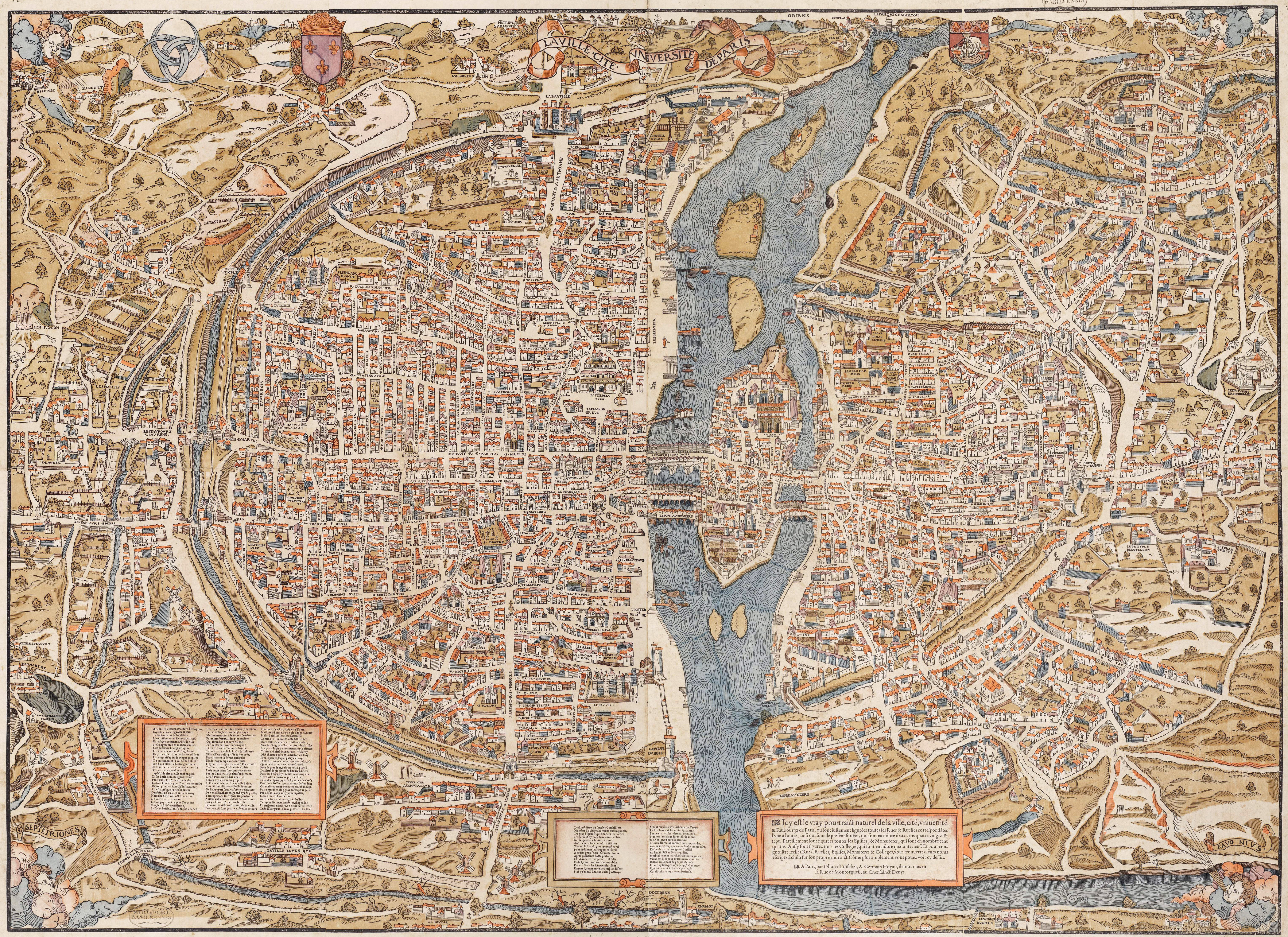
English: Plan of Paris by Truschet et Hoyau, scale ca. 1:4,500 (94 x 120 cm). Seefeld (Zurich) published this 1980 facsimile of the original map, also known as the plan de Bâle (Basel plan). Boutier gives a date of c. 1553 and estimates a scale of c. 1:7,000. The original is in color and was engraved on wood, 8 plates, 96 x 133 cm assembled.
Français : Le plan de Paris par Truschet et Hoyau, La ville, cité, université de Paris, échelle 1:4 500 environ (facsimile Seefeld, Zürich 1980). |
| References InfoField |
|
| Date |
circa 1550 date QS:P,+1550-00-00T00:00:00Z/9,P1480,Q5727902 |
| Source | NL, Universiteitsbibliotheek Vrije Universiteit, LL.06979gk: 130/od/1550; http://imagebase.ubvu.vu.nl/getobj.php?ppn=330025988 |
| Creator |
Olivier Truschet, engraver (?) Germain Hoyau, designer (?) |
| Georeferencing | Georeference the map in Wikimaps Warper If inappropriate please set warp_status = skip to hide. |
| Other versions |
|

|
Licensing
| Public domainPublic domainfalsefalse |
|
This work is in the public domain in its country of origin and other countries and areas where the copyright term is the author's life plus 100 years or fewer. | |
| This file has been identified as being free of known restrictions under copyright law, including all related and neighboring rights. | |
https://creativecommons.org/publicdomain/mark/1.0/PDMCreative Commons Public Domain Mark 1.0falsefalse
Captions
Items portrayed in this file
depicts
image/jpeg
File history
Click on a date/time to view the file as it appeared at that time.
| Date/Time | Thumbnail | Dimensions | User | Comment | |
|---|---|---|---|---|---|
| current | 12:17, 30 May 2011 | | 6,108 × 4,444 (23.18 MB) | FA2010 | {{Information |Description=Le plan de Paris par Truschet et Hoyau, ''La ville, cité, université de Paris'', ca. 1:4.500 (facsimile Seefeld, Zürich 1980) |Source=NL, Universiteitsbibliotheek Vrije Universiteit, LL.06979gk: 130/od/1550; http://imagebase. |
File usage
Global file usage
The following other wikis use this file:
- Usage on az.wikipedia.org
- Paris orta əsrlərdə
- Vikipediya:Həftənin seçilmiş məqaləsi/iyun 2016
- Vikipediya:Həftənin seçilmiş məqaləsi/23. Həftə 2016
- Vikipediya:Həftənin seçilmiş məqaləsi/iyul 2018
- Vikipediya:Həftənin seçilmiş məqaləsi/29. Həftə 2018
- Vikipediya:Həftənin seçilmiş məqaləsi/iyul 2022
- Vikipediya:Həftənin seçilmiş məqaləsi/29. Həftə 2022
- Usage on es.wikipedia.org
- Usage on fr.wikipedia.org
- Usage on ja.wikipedia.org
- Usage on nl.wikipedia.org
- Usage on tr.wikipedia.org
- Usage on uk.wikipedia.org
- Usage on vi.wikipedia.org
Metadata
This file contains additional information, probably added from the digital camera or scanner used to create or digitize it.
If the file has been modified from its original state, some details may not fully reflect the modified file.
| _error | 0 |
|---|