File:Pre-roman_iron_age_(map).PNG
From Wikipedia, the free encyclopedia
Size of this preview: 577 × 600 pixels. Other resolutions: 231 × 240 pixels | 462 × 480 pixels | 657 × 683 pixels.
Original file (657 × 683 pixels, file size: 38 KB, MIME type: image/png)
| This is a file from the Wikimedia Commons. Information from its description page there is shown below. Commons is a freely licensed media file repository. You can help. |
Summary
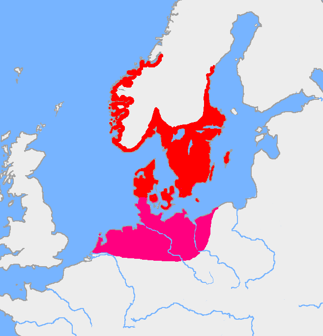
| DescriptionPre-roman iron age (map).PNG |
English: Map of the Nordic Iron Age and the Jastorf culture. |
||
| Date | |||
| Source | Image:Europe plain rivers.png and the Harper Atlas of World History (ed. Vidal-Naquet) in Swedish translation: Atlas över mänsklighetens historia. | ||
| Author | Copied from en:, uploaded by Wiglaf | ||
| Other versions |
|

Licensing
| Public domainPublic domainfalsefalse |
| This work has been released into the public domain by its author, Wiglaf. This applies worldwide. In some countries this may not be legally possible; if so: |
Captions
Add a one-line explanation of what this file represents
Items portrayed in this file
depicts
15 April 2005
File history
Click on a date/time to view the file as it appeared at that time.
| Date/Time | Thumbnail | Dimensions | User | Comment | |
|---|---|---|---|---|---|
| current | 05:43, 8 August 2017 | | 657 × 683 (38 KB) | Velivieras | Updated the map concerning the Åland islands. Scandinavian influence to the island started in 11th century. |
| 07:26, 15 August 2005 |  | 657 × 683 (32 KB) | Square87~commonswiki | from en.wiki {{PD}} |
File usage
The following pages on the English Wikipedia use this file (pages on other projects are not listed):
Global file usage
The following other wikis use this file:
- Usage on af.wikipedia.org
- Usage on als.wikipedia.org
- Usage on ast.wikipedia.org
- Usage on be.wikipedia.org
- Usage on ca.wikipedia.org
- Usage on ca.wiktionary.org
- Usage on cs.wikipedia.org
- Usage on da.wikipedia.org
- Usage on da.wikibooks.org
- Usage on de.wikipedia.org
- Usage on eml.wikipedia.org
- Usage on eo.wikipedia.org
- Usage on es.wikipedia.org
- Usage on et.wikipedia.org
- Usage on eu.wikipedia.org
- Usage on fa.wikipedia.org
- Usage on fi.wikipedia.org
- Usage on fi.wikibooks.org
- Usage on fr.wikipedia.org
- Usage on fr.wikiversity.org
- Usage on fr.wiktionary.org
- Usage on fy.wikipedia.org
- Usage on gl.wikipedia.org
- Usage on it.wikipedia.org
View more global usage of this file.
.PNG)
Metadata
This file contains additional information, probably added from the digital camera or scanner used to create or digitize it.
If the file has been modified from its original state, some details may not fully reflect the modified file.
| Horizontal resolution | 72 dpi |
|---|---|
| Vertical resolution | 72 dpi |
| Color space | Uncalibrated |
| Image width | 657 px |
| Image height | 683 px |
| Software used | Adobe Photoshop CC 2015.5 (Windows) |
| Date and time of digitizing | 11:40, 8 August 2017 |
| File change date and time | 11:42, 8 August 2017 |
| Date metadata was last modified | 11:42, 8 August 2017 |
| Unique ID of original document | xmp.did:3b6f5f36-b6d0-df42-b0d0-0b713d98cf8e |
Retrieved from "https://en.wikipedia.org/wiki/File:Pre-roman_iron_age_(map).PNG"
.PNG)