File:Shan_States-Map.png
From Wikipedia, the free encyclopedia
Size of this preview: 520 × 599 pixels. Other resolutions: 208 × 240 pixels | 417 × 480 pixels | 667 × 768 pixels | 889 × 1,024 pixels | 1,332 × 1,534 pixels.
Original file (1,332 × 1,534 pixels, file size: 192 KB, MIME type: image/png)
| This is a file from the Wikimedia Commons. Information from its description page there is shown below. Commons is a freely licensed media file repository. You can help. |

|
This map image could be re-created using vector graphics as an SVG file. This has several advantages; see Commons:Media for cleanup for more information. If an SVG form of this image is available, please upload it and afterwards replace this template with
{{vector version available|new image name}}.
It is recommended to name the SVG file “Shan States-Map.svg”—then the template Vector version available (or Vva) does not need the new image name parameter. |
Summary
| DescriptionShan States-Map.png |
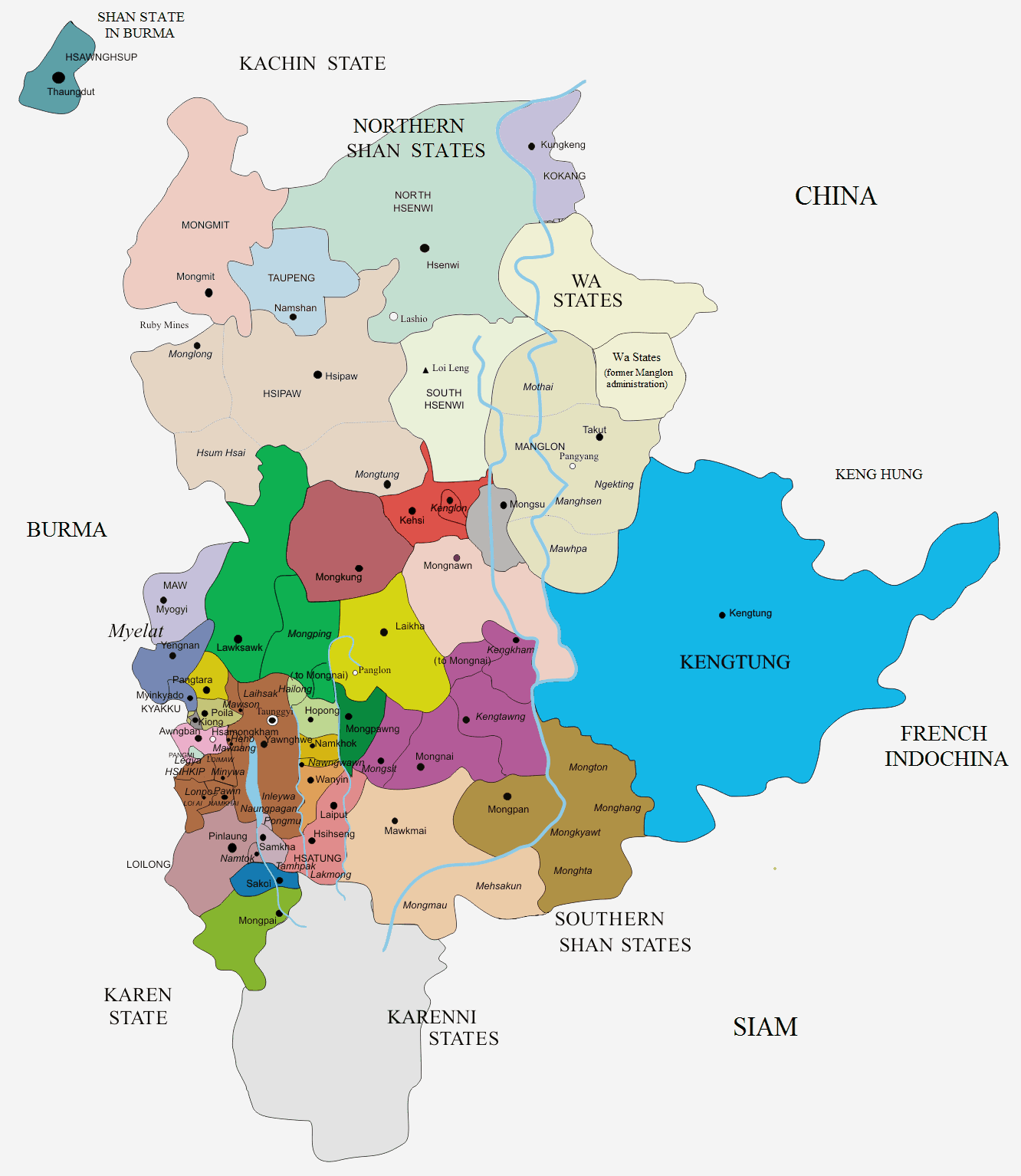
English: Map of the Shan States |
| Date | |
| Source | Catalan Wikipedia |
| Author | User:Jolle |
Licensing
This file is licensed under the Creative Commons Attribution-Share Alike 3.0 Unported license.
- You are free:
- to share – to copy, distribute and transmit the work
- to remix – to adapt the work
- Under the following conditions:
- attribution – You must give appropriate credit, provide a link to the license, and indicate if changes were made. You may do so in any reasonable manner, but not in any way that suggests the licensor endorses you or your use.
- share alike – If you remix, transform, or build upon the material, you must distribute your contributions under the same or compatible license as the original.
Captions
Add a one-line explanation of what this file represents
Items portrayed in this file
depicts
5 September 2014
File history
Click on a date/time to view the file as it appeared at that time.
| Date/Time | Thumbnail | Dimensions | User | Comment | |
|---|---|---|---|---|---|
| current | 06:59, 9 September 2014 | | 1,332 × 1,534 (192 KB) | Xufanc | Retouched |
| 13:35, 7 September 2014 |  | 1,332 × 1,534 (194 KB) | Xufanc | changed colors | |
| 12:10, 5 September 2014 |  | 1,332 × 1,534 (125 KB) | Xufanc | User created page with UploadWizard |
File usage
The following pages on the English Wikipedia use this file (pages on other projects are not listed):
- Hsenwi State
- Hsipaw State
- Kehsi Mansam
- Kenglon
- Kengtawng State
- Kengtung State
- Kyawkku State
- Kyong
- Laihka State
- Lawksawk State
- Loi-ai
- Mang Lon
- Maw (state)
- Mawkmai State
- Mongmit State
- Mongpan State
- Mongpawn
- North Hsenwi
- Shan States
- South Hsenwi
- Tawngpeng State
- Wa States
- Yawnghwe
- User:Tisquesusa/sandbox9
Global file usage
The following other wikis use this file:
- Usage on de.wikipedia.org
- Usage on it.wikipedia.org
- Usage on ja.wikipedia.org
- Usage on lt.wikipedia.org
- Usage on ml.wikipedia.org
- Usage on my.wikipedia.org
- Usage on pt.wikipedia.org
- Usage on ta.wikipedia.org
- Usage on th.wikipedia.org
Metadata
This file contains additional information, probably added from the digital camera or scanner used to create or digitize it.
If the file has been modified from its original state, some details may not fully reflect the modified file.
| Horizontal resolution | 37.79 dpc |
|---|---|
| Vertical resolution | 37.79 dpc |
Retrieved from "https://en.wikipedia.org/wiki/File:Shan_States-Map.png"