File:Tokyo-Kanto_definitions,_National_Capital_Region.png
From Wikipedia, the free encyclopedia
Size of this preview: 581 × 599 pixels. Other resolutions: 233 × 240 pixels | 600 × 619 pixels.
Original file (600 × 619 pixels, file size: 281 KB, MIME type: image/png)
| This is a file from the Wikimedia Commons. Information from its description page there is shown below. Commons is a freely licensed media file repository. You can help. |
Summary
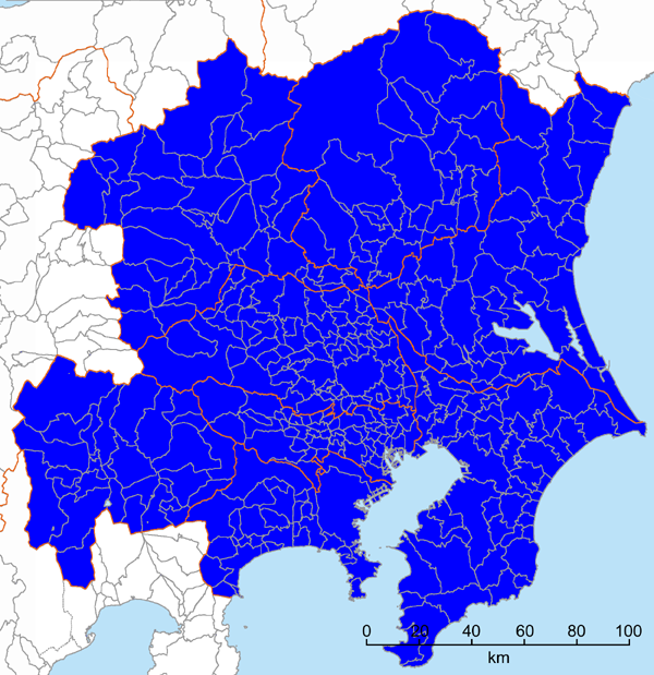
| DescriptionTokyo-Kanto definitions, National Capital Region.png | Map of the National Capital Region (首都圏) of Japan, one of the various definitions of Tokyo/Kanto. The definition is according to the National Capital Region Planning Act (首都圏整備法). It should be noted that in informal occasions, the word National Capital Region (首都圏) often means much smaller area (Greater Tokyo). |
| Date | |
| Source | Own work |
| Author | Kzaral |
| Permission (Reusing this file) |
GFDL |
| Other versions |
|


![File:Tokyo-Kanto definitions, Kanto MMA.png Map of the Kanto Major Metropolitan Area, one of the various definitions of Tokyo/Kanto. The definition is from Japan Statistic Bureau official website. [1]](/en/File:Tokyo-Kanto_definitions,_Kanto_MMA.png)


Licensing
I, the copyright holder of this work, hereby publish it under the following licenses:

|
Permission is granted to copy, distribute and/or modify this document under the terms of the GNU Free Documentation License, Version 1.2 or any later version published by the Free Software Foundation; with no Invariant Sections, no Front-Cover Texts, and no Back-Cover Texts. A copy of the license is included in the section entitled GNU Free Documentation License.http://www.gnu.org/copyleft/fdl.htmlGFDLGNU Free Documentation Licensetruetrue |
This file is licensed under the Creative Commons Attribution-Share Alike Attribution-Share Alike 4.0 International, 3.0 Unported, 2.5 Generic, 2.0 Generic and 1.0 Generic license.
- You are free:
- to share – to copy, distribute and transmit the work
- to remix – to adapt the work
- Under the following conditions:
- attribution – You must give appropriate credit, provide a link to the license, and indicate if changes were made. You may do so in any reasonable manner, but not in any way that suggests the licensor endorses you or your use.
- share alike – If you remix, transform, or build upon the material, you must distribute your contributions under the same or compatible license as the original.
You may select the license of your choice.
Captions
Add a one-line explanation of what this file represents
Items portrayed in this file
depicts
24 February 2008
File history
Click on a date/time to view the file as it appeared at that time.
| Date/Time | Thumbnail | Dimensions | User | Comment | |
|---|---|---|---|---|---|
| current | 15:24, 23 February 2008 | | 600 × 619 (281 KB) | Kzaral~commonswiki | |
| 15:17, 23 February 2008 |  | 600 × 619 (281 KB) | Kzaral~commonswiki | {{Information |Description=Map of the National Capital Region (首都圏) of Japan, one of the various definitions of Tokyo/Kanto. The definition is according to the National Capital Region Planning Act (首都圏整備法). It should be noted that in inf |
File usage
The following pages on the English Wikipedia use this file (pages on other projects are not listed):
Global file usage
The following other wikis use this file:
- Usage on ast.wikipedia.org
- Usage on da.wikipedia.org
- Usage on de.wikipedia.org
- Usage on es.wikipedia.org
- Usage on et.wikipedia.org
- Usage on fa.wikipedia.org
- Usage on fi.wikipedia.org
- Usage on fr.wikipedia.org
- Usage on he.wikipedia.org
- Usage on ja.wikipedia.org
- Usage on ko.wikipedia.org
- Usage on pt.wikipedia.org
- Usage on ru.wikipedia.org
- Usage on sco.wikipedia.org
- Usage on sv.wikipedia.org
- Usage on www.wikidata.org
- Usage on zh.wikipedia.org
Metadata
This file contains additional information, probably added from the digital camera or scanner used to create or digitize it.
If the file has been modified from its original state, some details may not fully reflect the modified file.
| Short title |
|
|---|---|
| Software used |