File:TransCanadaHWY.png
From Wikipedia, the free encyclopedia
Size of this preview: 746 × 599 pixels. Other resolutions: 299 × 240 pixels | 598 × 480 pixels | 860 × 691 pixels.
Original file (860 × 691 pixels, file size: 156 KB, MIME type: image/png)
| This is a file from the Wikimedia Commons. Information from its description page there is shown below. Commons is a freely licensed media file repository. You can help. |
Summary
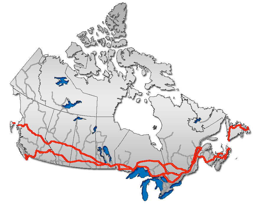
| DescriptionTransCanadaHWY.png |
English: Trans Canada Highway, as overlaid on Canada map
Français : Route transcanadienne sur la carte du Canada
Esperanto: Trans-Kanada Ŝoseo sur mapo de Kanado
日本語: トランスカナダハイウェイ地図。
Nederlands: Routemap van de Trans-Canada Highway |
| Date | |
| Source | GIS data |
| Author | Qyd (talk · contribs) |
| Permission (Reusing this file) |
All |
| Other versions |
|


Licensing
| Public domainPublic domainfalsefalse |
| I, the copyright holder of this work, release this work into the public domain. This applies worldwide. In some countries this may not be legally possible; if so: I grant anyone the right to use this work for any purpose, without any conditions, unless such conditions are required by law. |

|
This road map image could be re-created using vector graphics as an SVG file. This has several advantages; see Commons:Media for cleanup for more information. If an SVG form of this image is available, please upload it and afterwards replace this template with
{{vector version available|new image name}}.
It is recommended to name the SVG file “TransCanadaHWY.svg”—then the template Vector version available (or Vva) does not need the new image name parameter. |
| Annotations InfoField | This image is annotated: View the annotations at Commons |
671
500
9
9
860
691
The depicted route through Tadoussac, Québec on the north shore, then across a ferry, to Rimouski, then doubling back to Rivière du Loup to rejoin the mainline Transcanadienne is spurious. There is only one TCH routing from Montréal to Edmunston, which runs south shore Montréal-Lévis-Rivière du Loup on A-20 then 185/A-85 from Rivière du Loup through St. Louis du Ha! Ha! to Edmunston NB. Tadoussac and Rimouski are not on the route or any of its alternates.
Captions
Trans Canada Highway, as overlaid on Canada map
Items portrayed in this file
depicts
November 2006
File history
Click on a date/time to view the file as it appeared at that time.
| Date/Time | Thumbnail | Dimensions | User | Comment | |
|---|---|---|---|---|---|
| current | 00:39, 24 January 2007 | | 860 × 691 (156 KB) | Qyd | reload |
| 11:45, 13 December 2006 |  | 860 × 691 (156 KB) | Qyd | add On hwy 11 and 71 | |
| 02:06, 13 December 2006 |  | 860 × 691 (156 KB) | Qyd | oops again, forgot about yellowhead | |
| 01:48, 13 December 2006 |  | 860 × 691 (155 KB) | Qyd | oops, another correction | |
| 01:41, 13 December 2006 |  | 860 × 691 (155 KB) | Qyd | corrected route, thanks Bearcat | |
| 13:23, 8 December 2006 |  | 860 × 691 (157 KB) | Qyd | add major road network shadow | |
| 21:19, 21 November 2006 |  | 860 × 691 (142 KB) | Qyd | complete canada contour, UTM projection | |
| 09:53, 30 October 2006 |  | 677 × 300 (17 KB) | Matt314 | corrections by User:Bearcat: minor inaccuracy in Ontario (Highway 11 is not TCH south of North Bay; Hwy 400 is not TCH south of Coldwater.) | |
| 23:07, 21 February 2006 |  | 677 × 300 (18 KB) | Qyd | ||
| 23:47, 16 February 2006 |  | 693 × 312 (22 KB) | Qyd | Trans Canada Highway. Category:Maps_of_CanadaCategory:Highways_in_Canada |
File usage
The following pages on the English Wikipedia use this file (pages on other projects are not listed):
- Alberta Highway 1
- Alberta Highway 16
- British Columbia Highway 1
- British Columbia Highway 16
- CFB Shilo
- Confederation Bridge
- Manitoba Highway 1
- Manitoba Highway 16
- Ministry of Highways and Infrastructure (Saskatchewan)
- New Brunswick Route 16
- New Brunswick Route 2
- Newfoundland and Labrador Route 1
- Nova Scotia Highway 104
- Nova Scotia Highway 105
- Nova Scotia Highway 106
- Numbered highways in Canada
- Ontario Highway 11
- Ontario Highway 12
- Ontario Highway 17
- Ontario Highway 17A
- Ontario Highway 400
- Ontario Highway 417
- Ontario Highway 66
- Ontario Highway 69
- Ontario Highway 7
- Ontario Highway 71
- Perimeter Highway (Winnipeg)
- Prince Edward Island Route 1
- Quebec Autoroute 15
- Quebec Autoroute 20
- Quebec Autoroute 25
- Quebec Autoroute 40
- Quebec Autoroute 85
- Quebec Route 117
- Quebec Route 185
- Regina Bypass
- Saskatchewan Highway 1
- Saskatchewan Highway 16
- Trans-Canada Highway
- Yellowhead Highway
- Talk:Trans-Canada Highway
- User talk:Qyd
- Wikipedia:Graphics Lab/Map workshop/Archive/Apr 2019
- File talk:TransCanadaHWY.png
- Template:Trans-Canada
- Portal:Roads/Did you know
Global file usage
The following other wikis use this file:
- Usage on ar.wikipedia.org
- Usage on ca.wikipedia.org
- Usage on de.wikipedia.org
- Usage on eo.wikipedia.org
- Usage on es.wikipedia.org
- Usage on fa.wikipedia.org
- Usage on fi.wikipedia.org
- Usage on fr.wikipedia.org
- Usage on fr.wikivoyage.org
- Usage on he.wikivoyage.org
- Usage on hu.wikipedia.org
- Usage on id.wikipedia.org
- Usage on it.wikipedia.org
- Usage on ja.wikipedia.org
- Usage on ko.wikipedia.org
- Usage on nl.wikipedia.org
- Usage on no.wikipedia.org
- Usage on pl.wikipedia.org
- Usage on pt.wikipedia.org
- Usage on ru.wikipedia.org
- Usage on simple.wikipedia.org
- Usage on sr.wikipedia.org
- Usage on sv.wikipedia.org
- Usage on tr.wikipedia.org
- Usage on uk.wikipedia.org
- Usage on www.wikidata.org
- Usage on zh.wikipedia.org
Retrieved from "https://en.wikipedia.org/wiki/File:TransCanadaHWY.png"