File:US_Combined_Statistical_Areas.png
From Wikipedia, the free encyclopedia
Size of this preview: 776 × 600 pixels. Other resolutions: 311 × 240 pixels | 621 × 480 pixels | 994 × 768 pixels | 1,280 × 989 pixels | 2,112 × 1,632 pixels.
Original file (2,112 × 1,632 pixels, file size: 77 KB, MIME type: image/png)
| This is a file from the Wikimedia Commons. Information from its description page there is shown below. Commons is a freely licensed media file repository. You can help. |
Summary
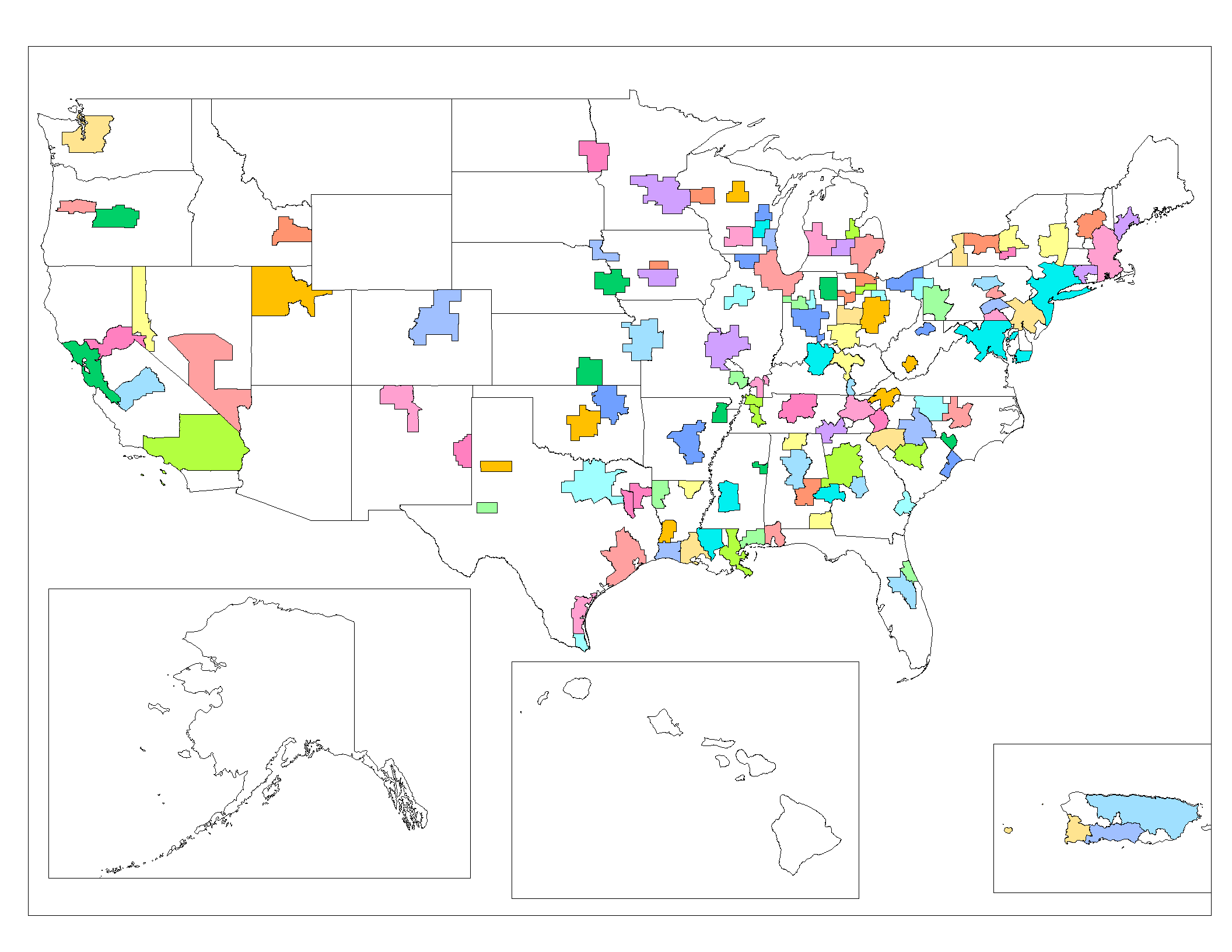
| DescriptionUS Combined Statistical Areas.png |
English: Map of the Combined Statistical Areas of the United States (based on 2005 US Census data). Created by Rarelibra 20:14, 25 October 2006 (UTC) for public domain use, using MapInfo v8.5 and various mapping resources. |
| Date | 25 October 2006 (original upload date) |
| Source | Transferred from en.wikipedia to Commons by Scott5114 using CommonsHelper. |
| Author | Rarelibra at English Wikipedia |
Licensing
| Public domainPublic domainfalsefalse |
| This work has been released into the public domain by its author, Rarelibra at English Wikipedia. This applies worldwide. In some countries this may not be legally possible; if so: Rarelibra grants anyone the right to use this work for any purpose, without any conditions, unless such conditions are required by law.Public domainPublic domainfalsefalse |
Original upload log
The original description page was here. All following user names refer to en.wikipedia.
- 2007-03-19 18:14 Rarelibra 2112×1632×8 (78858 bytes) updated map.
- 2006-10-25 20:14 Rarelibra 1056×816×8 (34909 bytes) Map of the Combined Statistical Areas of the United States (based on 2005 US Census data). Created by ~~~~ for public domain use, using MapInfo v8.5 and various mapping resources.
Captions
Add a one-line explanation of what this file represents
Items portrayed in this file
depicts
25 October 2006
File history
Click on a date/time to view the file as it appeared at that time.
| Date/Time | Thumbnail | Dimensions | User | Comment | |
|---|---|---|---|---|---|
| current | 06:32, 28 July 2008 | | 2,112 × 1,632 (77 KB) | File Upload Bot (Magnus Manske) | {{BotMoveToCommons|en.wikipedia}} {{Information |Description={{en|Map of the Combined Statistical Areas of the United States (based on 2005 US Census data). Created by Rarelibra 20:14, 25 October 2006 (UTC) for public domain use, u |
File usage
The following pages on the English Wikipedia use this file (pages on other projects are not listed):
Global file usage
The following other wikis use this file:
- Usage on ca.wikipedia.org
- Usage on es.wikipedia.org
- Usage on id.wikipedia.org
- Usage on ja.wikipedia.org
- Usage on www.wikidata.org
Retrieved from "https://en.wikipedia.org/wiki/File:US_Combined_Statistical_Areas.png"