File:US_physiographic_regions_map.jpg
From Wikipedia, the free encyclopedia
No higher resolution available.
US_physiographic_regions_map.jpg (597 × 386 pixels, file size: 66 KB, MIME type: image/jpeg)
| This is a file from the Wikimedia Commons. Information from its description page there is shown below. Commons is a freely licensed media file repository. You can help. |
Summary
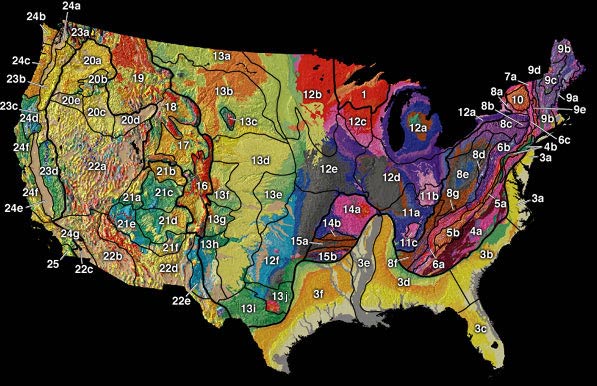
| DescriptionUS physiographic regions map.jpg |
English: USGS Physiographic Regions Map from [1] |
| Date | |
| Source | A Tapestry of Time and Terrain: Pamphlet to accompany Geologic Investigations Series I–2720 |
| Author | José F. Vigil, Richard J. Pike, and David G. Howell |
| Other versions |
|

Licensing
| Public domainPublic domainfalsefalse |
This image is in the public domain in the United States because it only contains materials that originally came from the United States Geological Survey, an agency of the United States Department of the Interior. For more information, see the official USGS copyright policy.
Bahasa Indonesia ∙ català ∙ čeština ∙ Deutsch ∙ eesti ∙ English ∙ español ∙ français ∙ galego ∙ italiano ∙ Nederlands ∙ português ∙ polski ∙ sicilianu ∙ suomi ∙ Tiếng Việt ∙ Türkçe ∙ български ∙ македонски ∙ русский ∙ മലയാളം ∙ 한국어 ∙ 日本語 ∙ 中文 ∙ 中文(简体) ∙ 中文(繁體) ∙ العربية ∙ فارسی ∙ +/− |
Original upload log
The original description page was here. All following user names refer to en.wikipedia.
- 2003-02-10 16:55 Sfmontyo 597×386×8 (68027 bytes) from http://tapestry.usgs.gov/physiogr/physio.html a public domain map from the USGS. Confirmed through email
Captions
Physiographic Regions Map of the United States
Items portrayed in this file
depicts
24 February 2000
File history
Click on a date/time to view the file as it appeared at that time.
| Date/Time | Thumbnail | Dimensions | User | Comment | |
|---|---|---|---|---|---|
| current | 16:50, 20 April 2008 | | 597 × 386 (66 KB) | File Upload Bot (Magnus Manske) | {{BotMoveToCommons|en.wikipedia}} {{Information |Description={{en|[http://tapestry.usgs.gov/physiogr/physio.html]}} |Source=Transferred from [http://en.wikipedia.org en.wikipedia] |Date=2003-02-10 (original upload date) |Author=Original uploader was [[:e |
File usage
The following pages on the English Wikipedia use this file (pages on other projects are not listed):
Global file usage
The following other wikis use this file:
- Usage on ar.wikipedia.org
- Usage on cs.wikipedia.org
- Velké planiny
- Skalnaté hory
- Vnitřní roviny
- Atlantská nížina
- Geografie Spojených států amerických
- Fyzická geografie Spojených států amerických
- Highland Rim
- Nashvillská pánev
- Wyomingská pánev
- Canyon Lands
- Vysoké plošiny
- Navajská oblast
- Datilská oblast
- Nížina Mexického zálivu
- Vnitřní vysočiny
- Bostonské hory
- Pobřežní nížina
- Usage on es.wikipedia.org
- Usage on fr.wikipedia.org
- Usage on it.wikipedia.org
- Usage on nn.wikipedia.org
- Usage on pl.wikipedia.org
- Usage on pt.wikipedia.org
- Usage on simple.wikipedia.org
- Usage on tr.wikipedia.org
Metadata
This file contains additional information, probably added from the digital camera or scanner used to create or digitize it.
If the file has been modified from its original state, some details may not fully reflect the modified file.
| _error | 0 |
|---|
Retrieved from "https://en.wikipedia.org/wiki/File:US_physiographic_regions_map.jpg"