File:US_states_by_date_of_statehood.PNG
From Wikipedia, the free encyclopedia
Size of this preview: 800 × 490 pixels. Other resolutions: 320 × 196 pixels | 640 × 392 pixels | 946 × 580 pixels.
Original file (946 × 580 pixels, file size: 20 KB, MIME type: image/png)
| This is a file from the Wikimedia Commons. Information from its description page there is shown below. Commons is a freely licensed media file repository. You can help. |

|
File:US states by date of statehood RWB.svg is a vector version of this file. It should be used in place of this PNG file when not inferior.
File:US states by date of statehood.PNG → File:US states by date of statehood RWB.svg
For more information, see Help:SVG.
|
 |
Summary
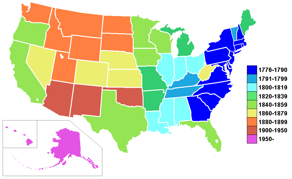
US states by date of statehood based on Image:BlankMap-USA-states.PNG and information at wikipedia:List of U.S. states by date of statehood
Other versions:
- Image:US states by date of statehood gradient.PNG
- Image:US states by date of statehood red.PNG
- Image:US states by date of statehood RWB.PNG
Licensing
I, the copyright holder of this work, hereby publish it under the following licenses:

|
Permission is granted to copy, distribute and/or modify this document under the terms of the GNU Free Documentation License, Version 1.2 or any later version published by the Free Software Foundation; with no Invariant Sections, no Front-Cover Texts, and no Back-Cover Texts. A copy of the license is included in the section entitled GNU Free Documentation License.http://www.gnu.org/copyleft/fdl.htmlGFDLGNU Free Documentation Licensetruetrue |
| This file is licensed under the Creative Commons Attribution-Share Alike 3.0 Unported license. | ||
| ||
| This licensing tag was added to this file as part of the GFDL licensing update.http://creativecommons.org/licenses/by-sa/3.0/CC BY-SA 3.0Creative Commons Attribution-Share Alike 3.0truetrue |
You may select the license of your choice.
Captions
Add a one-line explanation of what this file represents
Items portrayed in this file
depicts
File history
Click on a date/time to view the file as it appeared at that time.
| Date/Time | Thumbnail | Dimensions | User | Comment | |
|---|---|---|---|---|---|
| current | 10:48, 1 December 2006 | | 946 × 580 (20 KB) | Roke~commonswiki | |
| 00:02, 27 March 2006 |  | 946 × 580 (33 KB) | Roke~commonswiki | US states by date of statehood based on Image:BlankMap-USA-states.PNG and information at wikipedia:List of U.S. states by date of statehood Category:Maps of the United States |
File usage
The following pages on the English Wikipedia use this file (pages on other projects are not listed):
Global file usage
The following other wikis use this file:
- Usage on bg.wikipedia.org
- Usage on fi.wikipedia.org
- Usage on gl.wikipedia.org
- Usage on ro.wikipedia.org
- New York (stat)
- Stat al Statelor Unite ale Americii
- Georgia (stat american)
- Vermont
- Washington (stat)
- Arkansas
- California
- Colorado
- Connecticut
- Delaware
- Ohio
- Nevada
- Nevada (teritoriu SUA)
- Listă a statelor componente ale Statelor Unite ale Americii ordonate după data intrării în Uniune
- Iowa
- Florida
- Idaho
- Illinois
- Michigan
- Maryland
- Format:Ciot-stat-SUA
- Indiana
- Carolina de Nord
- Carolina de Sud
- Mississippi
- Kansas
- Kentucky
- Maine
- Idaho (teritoriu SUA)
- Massachusetts
- Minnesota
- Missouri
- Montana
- New Hampshire
- Dakota de Nord
- Utah
- Wisconsin
- Wyoming
- Arizona (teritoriu SCA)
- Dakota de Sud
- Oregon (teritoriu SUA)
- Virginia de Vest
- Bretton Woods
- Unionville, Frederick County, Maryland