File:UTC_hue4map_X_region_Africa.png
From Wikipedia, the free encyclopedia
No higher resolution available.
UTC_hue4map_X_region_Africa.png (382 × 387 pixels, file size: 12 KB, MIME type: image/png)
| This is a file from the Wikimedia Commons. Information from its description page there is shown below. Commons is a freely licensed media file repository. You can help. |
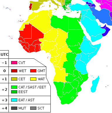
| DescriptionUTC hue4map X region Africa.png |
English: A map showing the different time zones in the African continent. |
| Date | (UTC) |
| Source | |
| Author |
|
| This is a retouched picture, which means that it has been digitally altered from its original version. The original can be viewed here: Africa-timezones.png:
|
I, the copyright holder of this work, hereby publish it under the following licenses:
This file is licensed under the Creative Commons Attribution-Share Alike 2.5 Generic, 2.0 Generic and 1.0 Generic license.
- You are free:
- to share – to copy, distribute and transmit the work
- to remix – to adapt the work
- Under the following conditions:
- attribution – You must give appropriate credit, provide a link to the license, and indicate if changes were made. You may do so in any reasonable manner, but not in any way that suggests the licensor endorses you or your use.
- share alike – If you remix, transform, or build upon the material, you must distribute your contributions under the same or compatible license as the original.
| This file is licensed under the Creative Commons Attribution-Share Alike 3.0 Unported license. | ||
| ||
| This licensing tag was added to this file as part of the GFDL licensing update.http://creativecommons.org/licenses/by-sa/3.0/CC BY-SA 3.0Creative Commons Attribution-Share Alike 3.0truetrue |

|
Permission is granted to copy, distribute and/or modify this document under the terms of the GNU Free Documentation License, Version 1.2 or any later version published by the Free Software Foundation; with no Invariant Sections, no Front-Cover Texts, and no Back-Cover Texts. A copy of the license is included in the section entitled GNU Free Documentation License.http://www.gnu.org/copyleft/fdl.htmlGFDLGNU Free Documentation Licensetruetrue |
You may select the license of your choice.
Original upload log
This image is a derivative work of the following images:
- File:Africa-timezones.png licensed with Cc-by-sa-2.5,2.0,1.0, Cc-by-sa-3.0-migrated, GFDL
- 2011-07-09T18:36:33Z Maphobbyist 382x392 (14964 Bytes) South Sudan has become independent on July 9, 2011. Sudan and South Sudan are shown with the new international border between them. The timezone remains the same.
- 2011-05-15T01:47:48Z Hamutan 382x392 (9790 Bytes) Updated to reflect recent changes to Egypt cancel DST
- 2009-07-27T23:08:55Z Thesevenseas 382x392 (15110 Bytes) Updated to reflect recent changes to Morocco using DST
- 2006-09-05T15:07:27Z Amakuru 382x392 (9850 Bytes) A map showing the different time zones in the African continent. Basic shell for map taken from [[:Image:Africa-regions.png]] ~~~
Uploaded with derivativeFX
Captions
Add a one-line explanation of what this file represents
Items portrayed in this file
depicts
28 September 2011
image/png
File history
Click on a date/time to view the file as it appeared at that time.
| Date/Time | Thumbnail | Dimensions | User | Comment | |
|---|---|---|---|---|---|
| current | 11:52, 30 October 2022 | | 382 × 387 (12 KB) | Heitordp | Updated Jordan and Syria; improved shapes |
| 09:46, 2 February 2021 |  | 382 × 387 (12 KB) | AKS471883 | South Sudan is UTC+2 | |
| 23:31, 30 December 2018 |  | 382 × 387 (12 KB) | AKS471883 | 2019.01.01 | |
| 09:54, 28 December 2018 |  | 382 × 387 (12 KB) | AKS471883 | Sudan is UTC+2, South Sudan is UTC+3 | |
| 12:49, 13 November 2018 |  | 382 × 387 (12 KB) | Maphobbyist | Check | |
| 11:46, 13 November 2018 |  | 382 × 392 (12 KB) | Maphobbyist | Updates: Morocco cancels DST and switches to UTC+1. | |
| 13:52, 24 December 2017 |  | 382 × 392 (12 KB) | Maphobbyist | Check | |
| 12:48, 24 December 2017 |  | 382 × 392 (12 KB) | Maphobbyist | Sudan switches to UTC+2, Northern Cyprus reverts to UTC+2 and DST, Qatar and Bahrain use UTC+3. | |
| 19:37, 13 September 2017 |  | 382 × 392 (6 KB) | NordNordWest | upd Namibia | |
| 09:18, 25 September 2016 |  | 382 × 392 (15 KB) | Maphobbyist | Since they appear on the map. Turkey and Northern Cypurs have abolished DST and are permanently fixed at UTC+3. Sources: http://famagusta-gazette.com/cyprus-will-have-two-time-zones-from-next-month-p36121-69.htm http://www.rte.ie/news/2016/0908/815258... |
File usage
The following pages on the English Wikipedia use this file (pages on other projects are not listed):
Global file usage
The following other wikis use this file:
- Usage on ar.wikipedia.org
- Usage on de.wikipedia.org
- Usage on eo.wikipedia.org
- Usage on es.wikipedia.org
- Usage on ilo.wikipedia.org
- Usage on it.wikipedia.org
- Usage on kk.wikipedia.org
- Usage on kn.wikipedia.org
- Usage on ko.wikipedia.org
- Usage on pa.wikipedia.org
- Usage on pnb.wikipedia.org
View more global usage of this file.
Metadata
This file contains additional information, probably added from the digital camera or scanner used to create or digitize it.
If the file has been modified from its original state, some details may not fully reflect the modified file.
| Horizontal resolution | 47.24 dpc |
|---|---|
| Vertical resolution | 47.24 dpc |
Retrieved from "https://en.wikipedia.org/wiki/File:UTC_hue4map_X_region_Africa.png"