File:World_in_300_BCE.PNG
From Wikipedia, the free encyclopedia
Original file (4,500 × 2,291 pixels, file size: 1.92 MB, MIME type: image/png)
| This is a file from the Wikimedia Commons. Information from its description page there is shown below. Commons is a freely licensed media file repository. You can help. |
Summary
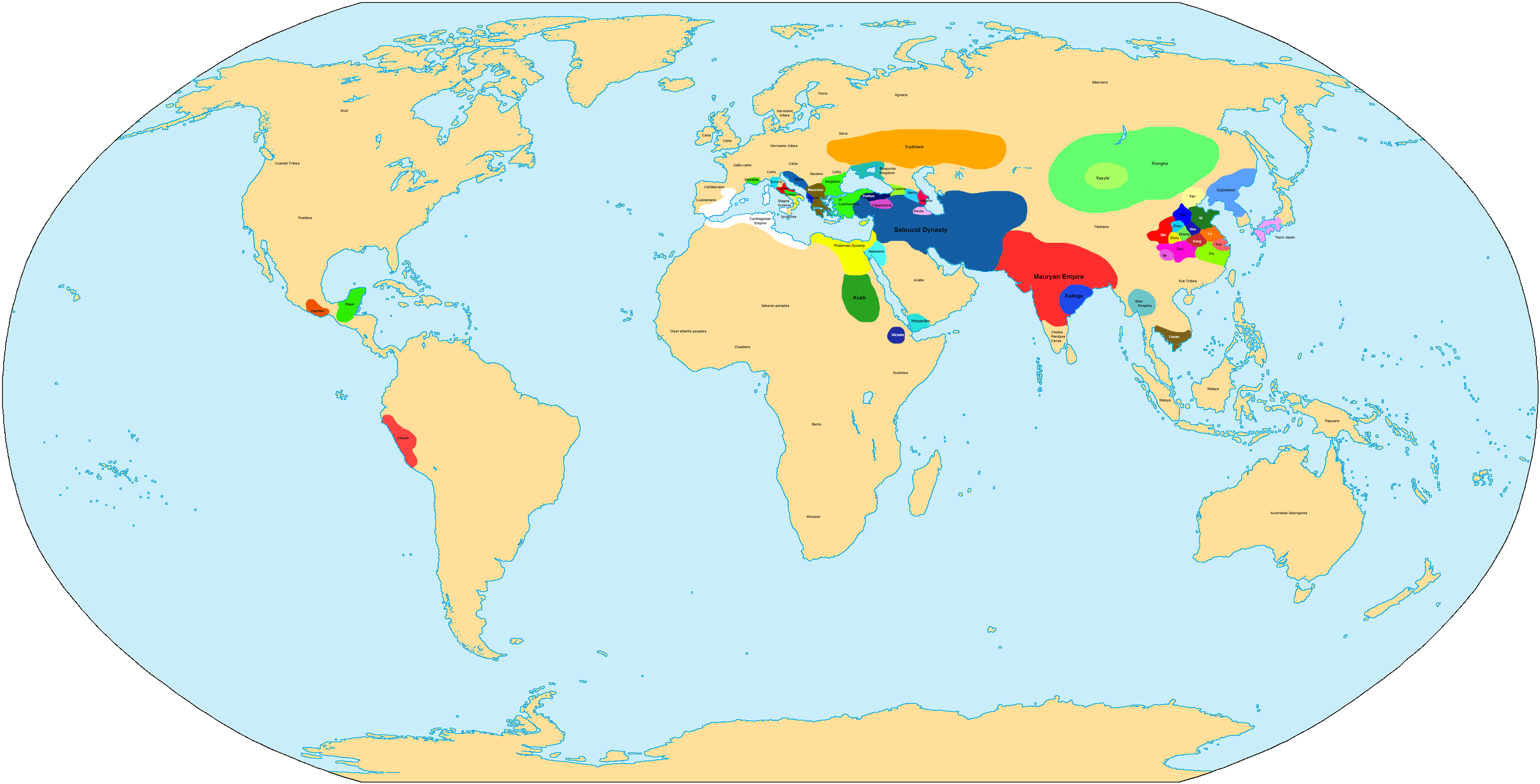
| DescriptionWorld in 300 BCE.PNG |
English: Map of the World in 300 BCE.
中文:公元前300年的世界地圖。 |
| Source | Own work |
| Author | Javierfv1212 |

|
This historical map image could be re-created using vector graphics as an SVG file. This has several advantages; see Commons:Media for cleanup for more information. If an SVG form of this image is available, please upload it and afterwards replace this template with
{{vector version available|new image name}}.
It is recommended to name the SVG file “World in 300 BCE.svg”—then the template Vector version available (or Vva) does not need the new image name parameter. |
| Maps of world history | |
| BC | |
|
| |
| AD |
1 · 50 · 100 · 200 · 250 · 300 · 400 · 500 · 700 · 750 · 820 · 900 · 1200 · 1500 · 1556 · 1648 · 1700 · 1750 · 1815 · 1859 · 1871 · 1914 · 1935 · 1954 · 1989 · 2000 · |
|
Maps of colonization history | |
|
see also: Eastern Hemisphere only maps template (1300BC-1500AD) | |
| (this template: · view · discuss ) | |
.jpg)
._LOC_2001620596.jpg)
Licensing
| Public domainPublic domainfalsefalse |
| I, the copyright holder of this work, release this work into the public domain. This applies worldwide. In some countries this may not be legally possible; if so: I grant anyone the right to use this work for any purpose, without any conditions, unless such conditions are required by law. |
Captions
Items portrayed in this file
depicts
some value
image/png
File history
Click on a date/time to view the file as it appeared at that time.
| Date/Time | Thumbnail | Dimensions | User | Comment | |
|---|---|---|---|---|---|
| current | 18:12, 19 June 2022 | | 4,500 × 2,291 (1.92 MB) | Luca090902 | Reverted to version as of 01:25, 4 November 2007 (UTC) |
| 01:29, 10 September 2021 |  | 700 × 356 (132 KB) | ItsJustdancefan | – | |
| 01:25, 4 November 2007 |  | 4,500 × 2,291 (1.92 MB) | Javierfv1212 | ||
| 01:23, 4 November 2007 |  | 5,000 × 2,545 (2.12 MB) | Javierfv1212 | {{Information |Description= |Source=self-made |Date= |Author= Javierfv1212 |Permission= |other_versions= }} Category:Maps of the world showing history |
File usage
Global file usage
The following other wikis use this file:
- Usage on de.wikipedia.org
- Usage on fr.wikipedia.org
- Usage on gl.wikipedia.org
- Usage on he.wikipedia.org
- Usage on id.wikipedia.org
- Usage on io.wikipedia.org
- Usage on pt.wikipedia.org
- Usage on sv.wikipedia.org
- Usage on zh.wikipedia.org
Metadata
This file contains additional information, probably added from the digital camera or scanner used to create or digitize it.
If the file has been modified from its original state, some details may not fully reflect the modified file.
| Horizontal resolution | 28.35 dpc |
|---|---|
| Vertical resolution | 28.35 dpc |