
Pampagrande
Place in Bolivia / From Wikipedia, the free encyclopedia
Pampagrande (also Pampa Grande), Bolivia (18°05′50″S 64°06′58″W) lies about 200 kilometers to the West of Santa Cruz de la Sierra in the foothills of the Andes at an altitude of 2000 meters. This tiny community on a river of the same name suffers from financial hardship. The majority of the streets are made of earth, and until recently, there was no plumbing, telephone or electricity in the community. There are a handful of shops and one eating house in the town. Local farmers grow maize and watermelons where conditions allow. There is a splendid, masonry, single arch bridge over the Rio Pampagrande on the outskirts of town.
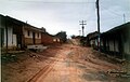 Only the streets around the Plaza are paved.
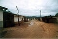 Pampagrande is not a wealthy part of Bolivia.
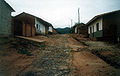 When it rains the streets become a sea of mud.
 Few people here can afford a car or a truck. Just as well!
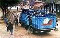 A wedding party arrives at the plaza Pampagrande. Time for celebration.


This article may be in need of reorganization to comply with Wikipedia's layout guidelines. (October 2022) |
- Were you looking for the Peruvian archaeological site of Pampa Grande?
Quick Facts Country, Elevation ...
Pampagrande | |
|---|---|
 | |
 Flag  Coat of arms | |
 Pampagrande Location within Bolivia | |
| Coordinates: 18°5′50″S 64°6′58″W | |
| Country | Bolivia |
| Elevation | 2,000 m (7,000 ft) |
| Time zone | UTC-4 (BOT) |
Close
The surrounding country is termed "Medium Altitude Semi-desert".
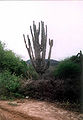 The arid landscape is dominated by giant cactus and thorny scrub.
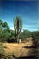 To wrest a living from the land around here is a Herculean task.
 Nevertheless, for some there is no alternative. Campasinos near Pampagrande.


