Portal:Volcanoes
Wikipedia portal for content related to Volcanoes / From Wikipedia, the free encyclopedia
Portal maintenance status: (June 2018)
|
The Volcanoes portal

On Earth, volcanoes are most often found where tectonic plates are diverging or converging, and because most of Earth's plate boundaries are underwater, most volcanoes are found underwater. For example, a mid-ocean ridge, such as the Mid-Atlantic Ridge, has volcanoes caused by divergent tectonic plates whereas the Pacific Ring of Fire has volcanoes caused by convergent tectonic plates. Volcanoes can also form where there is stretching and thinning of the crust's plates, such as in the East African Rift and the Wells Gray-Clearwater volcanic field and Rio Grande rift in North America. Volcanism away from plate boundaries has been postulated to arise from upwelling diapirs from the core–mantle boundary, 3,000 kilometers (1,900 mi) deep within Earth. This results in hotspot volcanism, of which the Hawaiian hotspot is an example. Volcanoes are usually not created where two tectonic plates slide past one another.
Large eruptions can affect atmospheric temperature as ash and droplets of sulfuric acid obscure the Sun and cool Earth's troposphere. Historically, large volcanic eruptions have been followed by volcanic winters which have caused catastrophic famines.
Other planets besides Earth have volcanoes. For example, volcanoes are very numerous on Venus. In 2009, a paper was published suggesting a new definition for the word 'volcano' that includes processes such as cryovolcanism. It suggested that a volcano be defined as 'an opening on a planet or moon's surface from which magma, as defined for that body, and/or magmatic gas is erupted.'
This article mainly covers volcanoes on Earth. See § Volcanoes on other celestial bodies and Cryovolcano for more information. (Full article...)
Selected article - show another

Craters of the Moon National Monument and Preserve is a U.S. national monument and national preserve in the Snake River Plain in central Idaho. It is along US 20 (concurrent with US 93 and US 26), between the small towns of Arco and Carey, at an average elevation of 5,900 feet (1,800 m) above sea level.
The Monument was established on May 2, 1924. In November 2000, a presidential proclamation by President Clinton greatly expanded the Monument area. The 410,000-acre National Park Service portions of the expanded Monument were designated as Craters of the Moon National Preserve in August 2002. It spreads across Blaine, Butte, Lincoln, Minidoka, and Power counties. The area is managed cooperatively by the National Park Service and the Bureau of Land Management (BLM). (Full article...)Did you know

- ... that the 60 million years old Carmelo Formation (pictured) is made out of thousands of layers of volcanic pebbles, sandstone and mudstone with fossils?
- ... that one of the activities that are possible at the Nevado de Toluca National Park is scuba diving in the two volcanic crater lakes?
- ... that the Popocatépetl volcano occasionally dumps ash on the municipality of Ozumba, Mexico?
- ... that in August 2001, the Galileo spacecraft flew through the sulfur dioxide gas plume of the Ionian volcano Thor?
- ... that the Garibaldi Volcanic Belt in southwestern British Columbia is the site of Canada's largest recorded Holocene explosive eruption 2,350 years ago at the Mount Meager massif?
- ... that most of the recent volcanism in New Zealand has been along the line of the Taupo Volcanic Zone and the Kermadec island arc?
- ... that the asphalt volcano is a rare submarine volcano composed of asphalt and erupting petroleum and methane instead of lava?
- ... that eruptions from Mahogany Mountain, a caldera volcano, produced rock formations in Leslie Gulch over 15 million years ago?
General images
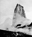 Image 1The lava spine that developed after the 1902 eruption of Mount Pelée (from Types of volcanic eruptions)
 Image 2A major eruption of Gran Canaria took place around 14 million years ago. (from Timeline of volcanism on Earth)
 Image 3The final eruptions in the creation of Banks Peninsula in New Zealand occurred about 9 million years ago. (from Timeline of volcanism on Earth)
 Image 4A diagram of a Subglacial eruption. (key: 1. Water vapor cloud 2. Crater lake 3. Ice 4. Layers of lava and ash 5. Stratum 6. Pillow lava 7. Magma conduit 8. Magma chamber 9. Dike) Click for larger version. (from Types of volcanic eruptions)
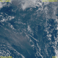 Image 5Satellite animation of the initial ash plume and shockwave of the 2022 Hunga Tonga–Hunga Ha’apai eruption and tsunami. The massive explosive eruption was hundreds of times more powerful than the atomic bomb dropped on Hiroshima. (from Volcanism)
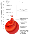 Image 6VEI and ejecta volume correlation (from Timeline of volcanism on Earth)
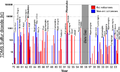 Image 7Sulfur dioxide emissions by volcanoes. Mount Pinatubo: 20 million tons of sulfur dioxide. (from Timeline of volcanism on Earth)
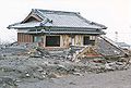
- Image 9Diagram showing the scale of VEI correlation with total ejecta volume (from Types of volcanic eruptions)

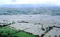 Image 11Lahar flows from the 1985 eruption of Nevado del Ruiz, which totally destroyed Armero in Colombia (from Types of volcanic eruptions)
 Image 12Diagram of Peléan eruption. (key: 1. Ash plume 2. Volcanic ash rain 3. Lava dome 4. Volcanic bomb 5. Pyroclastic flow 6. Layers of lava and ash 7. Stratum 8. Magma conduit 9. Magma chamber 10. Dike) Click for larger version. (from Types of volcanic eruptions)
 Image 13Olympus Mons (Latin, "Mount Olympus"), located on the planet Mars, is the tallest known mountain in the Solar System. (from Volcanism)
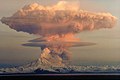 Image 1421 April 1990 eruptive column from Redoubt Volcano, as viewed to the west from the Kenai Peninsula (from Types of volcanic eruptions)
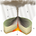 Image 15Diagram of a Plinian eruption. (key: 1. Ash plume 2. Magma conduit 3. Volcanic ash rain 4. Layers of lava and ash 5. Stratum 6. Magma chamber) Click for larger version. (from Types of volcanic eruptions)
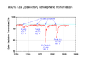 Image 16MLO transmission ratio - Solar radiation reduction due to volcanic eruptions (from Timeline of volcanism on Earth)
 Image 17Some features of volcanism found in Earth's crust (from Volcanism)
 Image 18Sarychev Peak: the sulphur dioxide cloud generated by the eruption on June 12, 2009 (in Dobson units). (from Timeline of volcanism on Earth)
 Image 19Cross section diagram of Earth showing some settings for volcanism on the planet (from Volcanism)
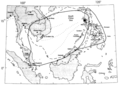 Image 20Location of Mount Pinatubo, showing area over which ash from the 1991 eruption fell. (from Timeline of volcanism on Earth)

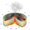 Image 23Diagram of a Hawaiian eruption. (key: 1. Ash plume 2. Lava fountain 3. Crater 4. Lava lake 5. Fumaroles 6. Lava flow 7. Layers of lava and ash 8. Stratum 9. Sill 10. Magma conduit 11. Magma chamber 12. Dike) Click for larger version. (from Types of volcanic eruptions)
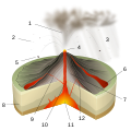 Image 24Diagram of a Strombolian eruption. (key: 1. Ash plume 2. Lapilli 3. Volcanic ash rain 4. Lava fountain 5. Volcanic bomb 6. Lava flow 7. Layers of lava and ash 8. Stratum 9. Dike 10. Magma conduit 11. Magma chamber 12. Sill) Click for larger version. (from Types of volcanic eruptions)
 Image 25Phreatic explosion captured at the Main Crater of Taal Volcano. Photo taken from the installed IP camera of the Philippine Institute of Volcanology and Seismology (PHIVOLCS) monitoring the volcano. (from Decade Volcanoes)
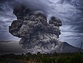
 Image 27An example of the lava arcs formed during Strombolian activity. This image is of Stromboli itself. (from Types of volcanic eruptions)
 Image 28Some of the eruptive structures formed during volcanic activity (counterclockwise): a Plinian eruption column, Hawaiian pahoehoe flows, and a lava arc from a Strombolian eruption (from Types of volcanic eruptions)
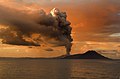
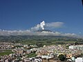


 Image 33Distribution of selected hotspots. The numbers in the figure are related to the listed hotspots on Hotspot (geology). (from Timeline of volcanism on Earth)
 Image 34Diagram of a Submarine eruption. (key: 1. Water vapor cloud 2. Water 3. Stratum 4. Lava flow 5. Magma conduit 6. Magma chamber 7. Dike 8. Pillow lava) Click to enlarge. (from Types of volcanic eruptions)
 Image 35The high initial temperatures of silicate lavas mean that they emit visible light before cooling. (from Volcanism)
 Image 36Satellite measurements of ash and aerosol emissions from Mount Pinatubo. (from Timeline of volcanism on Earth)
 Image 37Diagram of a phreatic eruption. (key: 1. Water vapor cloud 2. Magma conduit 3. Layers of lava and ash 4. Stratum 5. Water table 6. Explosion 7. Magma chamber) (from Types of volcanic eruptions)
 Image 38TOMS sulfur dioxide from the June 15, 1991 eruption of Mount Pinatubo. (from Timeline of volcanism on Earth)
 Image 39Diagram of a Vulcanian eruption. (key: 1. Ash plume 2. Lapilli 3. Lava fountain 4. Volcanic ash rain 5. Volcanic bomb 6. Lava flow 7. Layers of lava and ash 8. Stratum 9. Sill 10. Magma conduit 11. Magma chamber 12. Dike) Click for larger version. (from Types of volcanic eruptions)
 Image 41A gentle, or effusive, volcanic eruption, in which liquid material (lava) gently flows from a vent, in this case in south-eastern Hawai’i island (from Volcanism)
 Image 42Lava-flooded craters and large expanses of smooth volcanic plains on Mercury (from List of extraterrestrial volcanoes)
 Image 43Diagrammatic representation of a plume on Enceladus (from Volcanism)
 Image 44NASA, Global Dimming - El Chichon, VEI 5; Pinatubo, VEI 6. (from Timeline of volcanism on Earth)
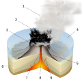 Image 45Diagram of a Surtseyan eruption. (key: 1. Water vapor cloud 2. Compressed ash 3. Crater 4. Water 5. Layers of lava and ash 6. Stratum 7. Magma conduit 8. Magma chamber 9. Dike) Click for larger version. (from Types of volcanic eruptions)

.jpg)


.jpg)


Selected biography - show another
Selected picture
 |
| Credit: Expedition 5 crew |
An October 2002 eruption of Mount Etna, a volcano on the Italian island of Sicily, as seen from the International Space Station. Etna is the largest of Italy's three active volcanoes and one of the most active in the world. This eruption, one of Etna's most vigorous in years, was triggered by a series of earthquakes. Ashfall was reported as far away as Libya, 600 km (373 mi) to the south.
Selected quote
"Do we need to bring a sleeping bag, or will the volcano keep us warm at night?"
Related portals
WikiProjects

Volcanoes topics
Subcategories
![]()
Featured work and other approved content

Featured articles: 1980 eruption of Mount St. Helens • 2007–2008 Nazko earthquakes • Amchitka • Armero tragedy • Craters of the Moon National Monument and Preserve • Cerro Azul (Chile volcano) • David A. Johnston • Enceladus (moon) • Geology of the Lassen volcanic area • Io (moon) • Kamaʻehuakanaloa Seamount • Mauna Kea • Mauna Loa • Metacomet Ridge • Mono-Inyo Craters • Mount Cayley volcanic field • Mount St. Helens • Mount Tambora • Nevado del Ruiz • Surtsey • The Volcano (British Columbia) • Triton (moon) • Upper and Lower Table Rock • Volcanism on Io • Volcano (South Park) • Yellowstone National Park
Featured lists: List of volcanoes in Indonesia • List of volcanoes in the Hawaiian – Emperor seamount chain • List of largest volcanic eruptions
Featured pictures: There are currently 43 volcano-related Featured pictures. A full gallery can be seen here.

Good articles: Abyssal plain • Amak Volcano • Anahim hotspot • Axial Seamount • Ben Nevis • Bowie Seamount • Crater Lake • Davidson Seamount • Ferdinandea • Gareloi Volcano • Geyser • Glacier Peak • Hawaii hotspot • Hualālai • Kohala (mountain) • Lake Toba • Minoan eruption • Mount Adams (Washington) • Mount Bailey • Mount Baker • Mount Cleveland (Alaska) • Mount Edziza volcanic complex • Mount Garibaldi • Mount Hood • Mount Kenya • Mount Rainier • Mount Redoubt • Mount Tehama • Mount Thielsen • Mount Vesuvius • Peter I Island • Roxy Ann Peak • Rùm • Sakurajima • Sangay • Silverthrone Caldera • Staffa • Types of volcanic eruptions • Volcanic ash • Weh Island • Wells Gray-Clearwater volcanic field • Yamsay Mountain
Valued pictures: A gallery of volcano-related valued pictures can be seen here.
What you can do

- Add the {{WikiProject Volcanoes}} message box to talk pages of articles within the scope of this project, including appropriate assessments, if needed.
- Add appropriate volcano type categories to articles, and verify the accuracy of any existing categories. See the section "Categorization" below.
- Add {{infobox mountain}} to articles if needed and missing, and add volcano-related fields to existing infoboxes if these are missing.
- Expand volcano articles which are stubs, especially by adding photos and (most importantly) proper references.
- Help improve articles related to Hawaiian and Canadian volcanism by joining the Hawaiian and Canadian workgroups.
- Improve some of the project's most visible articles.
Associated Wikimedia
The following Wikimedia Foundation sister projects provide more on this subject:
-
 Commons
Free media repository -
 Wikibooks
Free textbooks and manuals -
 Wikidata
Free knowledge base -
 Wikinews
Free-content news -
 Wikiquote
Collection of quotations -
 Wikisource
Free-content library -
 Wikiversity
Free learning tools -
 Wiktionary
Dictionary and thesaurus


