User:Gazamp/Safekeeping
From Wikipedia, the free encyclopedia
The Andes (/ˈændiːz/ AN-deez), Andes Mountains or Andean Mountain Range (Spanish: Cordillera de los Andes; Quechua: Anti) are the longest continental mountain range in the world, forming a continuous highland along the western edge of South America. The range is 8,900 km (5,530 mi) long and 200 to 700 km (124 to 435 mi) wide (widest between 18°S and 20°S latitude) and has an average height of about 4,000 m (13,123 ft). The Andes extend from South to North through seven South American countries.: Argentina, Chile, Bolivia, Peru, Ecuador, Colombia and western Venezuela.
| {{{1}}} |
|2=
|2=

Along their length, the Andes are split into several ranges, separated by intermediate depressions. The Andes are the location of several high plateaus—some of which host major cities such as Quito, Bogotá, Cali, Arequipa, Medellín, Bucaramanga, Sucre, Mérida, El Alto and La Paz. The Altiplano Plateau is the world's second-highest after the Tibetan Plateau. These ranges are in turn grouped into three major divisions based on climate: the Tropical Andes, the Dry Andes, and the Wet Andes. (Full article...)
Selected general articles
 Image 1
 Aerial view of Tupungato volcano from Argentina.
Tupungato, one of the highest mountains in the Americas, is a massive Andean lava dome dating to Pleistocene times. It lies on the Argentina–Chile border, between the Chilean Metropolitan Region (near a major international highway about 80 km (50 mi) east of Santiago) and the Argentine province of Mendoza, about 100 km (62 mi) south of Aconcagua, the highest peak of both the Southern and Western hemispheres. Immediately to its southwest is the active Tupungatito volcano (literally, little Tupungato), which last erupted in 1987.
Tupungato Department, an important Argentine wine-producing region in Mendoza province, is named for the volcano. Recent Chilean mapping indicates it has a height of 6635m. (Full article...)- Image 2
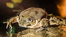 Individual from the captive breeding program at Prague Zoo
Telmatobius culeus, commonly known as the Titicaca water frog or Lake Titicaca frog, is a medium-large to very large and endangered species of frog in the family Telmatobiidae. It is entirely aquatic and found only in the Lake Titicaca basin, including rivers that flow into it and smaller connected lakes like Arapa, Lagunillas and Saracocha, in the Andean highlands of Bolivia and Peru. In reference to its excessive amounts of skin, it has jokingly been referred to as the Titicaca scrotum (water) frog.
It is closely related to the more widespread and semiaquatic marbled water frog (T. marmoratus), which also occurs in shallow, coastal parts of Lake Titicaca, but lacks the excessive skin and it is generally smaller (although overlapping in size with some forms of the Titicaca water frog). (Full article...) - Image 3
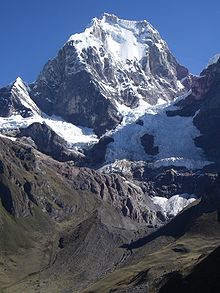
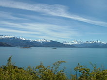 San Valentin as seen from the shore of Lake General Carrera
Monte San Valentin, also known as Monte San Clemente, is the highest mountain in Chilean Patagonia and the highest mountain south of 37°S outside Antarctica. It stands at the north end of the North Patagonian Icefield.
Monte San Valentin can be climbed from Lago Leones, to the south east, or from Laguna San Rafael, to the west. The ascent is long and is particularly subject to bad weather. (Full article...) - Image 4
 Pico Humboldt in 2008
Pico Humboldt is Venezuela's second highest peak, at 4,925 metres above sea level. It is located in the Sierra Nevada de Merida, in the Venezuelan Andes of (Mérida State). The peak, its sister peak Pico Bonpland, and the surrounding páramos are protected by the Sierra Nevada National Park. The mountain is named after German explorer and naturalist Alexander von Humboldt. (Full article...) - Image 5
 Lastarria seen from Mina La Casualidad
Lastarria is a 5,697 metres (18,691 ft) high stratovolcano that lies on the border between Chile and Argentina. It is remote, and the surroundings are uninhabited but can be reached through an unpaved road. The volcano is part of the Central Volcanic Zone, one of the four segments of the volcanic arc of the Andes. Over a thousand volcanoes—of which about 50 are active—lie in this over 1,500 kilometres (930 mi) long chain of volcanoes, which is generated by subduction of the Nazca Plate beneath the South American Plate.
The volcano is constituted by two volcanic edifices that form a ridge, and one subsidiary lava flow field southwest of the main volcanoes. The main edifice features several aligned craters that form a line. There is no recorded eruptive activity, but the volcano displays vigorous fumarolic activity on its northern side and within the craters. It is located on top of older volcanic rocks and features both andesite and dacite. (Full article...) - Image 6Touching the Void is a 2003 survival documentary film directed by Kevin Macdonald and starring Brendan Mackey, Nicholas Aaron, and Ollie Ryall. The plot concerns Joe Simpson and Simon Yates' near-fatal descent after making the first successful ascent of the West Face of Siula Grande in the Cordillera Huayhuash in the Peruvian Andes, in 1985. It is based on Simpson's 1988 book of the same name.
Critically acclaimed, Touching the Void was listed in PBS's "100 Greatest Documentaries of All Time". The Guardian described it as "the most successful documentary in British cinema history". (Full article...) - Image 7
 Location within Bolivia
Illampu is the fourth highest mountain in Bolivia. It is located in the northern section of the Cordillera Real, part of the Andes, east of Lake Titicaca. It lies just north of the slightly higher Janq'u Uma, near the town of Sorata. Laguna Glaciar, located in the Illampu-Janq'u Uma massif, is the 17th highest lake in the world.
Despite being lower than Janq'u Uma, Illampu has a steeper peak, with more local relief, and is a somewhat harder climb. In fact it has "the hardest normal route on any of the 6,000 metre peaks in Bolivia." The easiest route, by the Southwest Ridge, is rated AD (Fairly Difficult), with snow slopes up to 65 degrees. It is accessed from a high camp on the north side of the massif. The peak was first climbed on June 7, 1928 via this route, by Hans Pfann, Alfred Horeschowsky, Hugo Hörtnagel (Germans) and Erwin Hein (Austrian). Other routes include the "German Route" on the southwest face and the South Face route, both approached from the west side of the massif. (Full article...) - Image 8
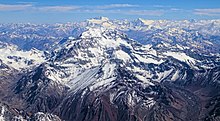 Aconcagua from the south
Aconcagua (Spanish pronunciation: [akoŋˈkaɣwa]) is a mountain in the Principal Cordillera of the Andes mountain range, in Mendoza Province, Argentina. It is the highest mountain in the Americas, the highest outside Asia, and the highest in both the Western Hemisphere and the Southern Hemisphere with a summit elevation of 6,961 metres (22,838 ft). It lies 112 kilometres (70 miles) northwest of the provincial capital, the city of Mendoza, about five kilometres (three miles) from San Juan Province, and 15 km (9 mi) from Argentina's border with Chile. The mountain is one of the Seven Summits of the seven continents.
Aconcagua is bounded by the Valle de las Vacas to the north and east and the Valle de los Horcones Inferior to the west and south. The mountain and its surroundings are part of the Aconcagua Provincial Park. The mountain has a number of glaciers. The largest glacier is the Ventisquero Horcones Inferior at about 10 km (6 mi) long, which descends from the south face to about 3,600 m (11,800 ft) in elevation near the Confluencia camp.
Two other large glacier systems are the Ventisquero de las Vacas Sur and Glaciar Este/Ventisquero Relinchos system at about 5 km (3 mi) long. The best known is the northeastern or Polish Glacier, as it is a common route of ascent. (Full article...) - Image 9The Pico Pan de Azúcar, at 4680 meters above sea level, is the ninth highest mountain of Venezuela, and the third highest of the Sierra de la Culata range in the Mérida State. Its name, which translates as "Bread of Sugar", is due to the sandy slopes of the mountain, which resembles "Pan dulce", a kind of bread sprinkled with sugar eaten in the country. The summit offers a scenic view, including Lake Maracaibo, Sierra Nevada de Mérida and the surrounding mountains of the Sierra de la Culata. (Full article...)
- Image 10
 Falso Azufre volcanic complex and Laguna Verde.
Falso Azufre is a complex volcano at the border of Argentina and Chile.
Falso Azufre is elongated in east–west direction and contains craters and lava domes; most craters have diameters of 300–600 metres (980–1,970 ft) with the exception of the main crater, which is 1 by 1.3 kilometres (0.62 mi × 0.81 mi) wide. The highest summit Cerro Falso Azufre lies at the western end in Chile, which has mostly generated pyroclastic material from craters. The probably youngest segment of the volcano is the eastern section in Argentina, where two lava domes and two cones are located; these form the Dos Conos volcano. Some lava flows linked to Dos Conos are up to 7 kilometres (4.3 mi) long. The oldest is known as the Kunstmann edifice on the northwestern side of Falso Azufre; Kunstmann volcano features a 3 kilometres (1.9 mi) wide scar formed by a sector collapse. Falso Azufre with a base surface of 387 square kilometres (149 sq mi) is one of the biggest volcanoes in the area. The presence of two oppositely curved vent alignments gives the complex an arc-like shape which reaches heights of about 5,900 metres (19,400 ft) above sea level. (Full article...) - Image 11
 Ritacuba Blanco from the west
Ritacuba Blanco is the highest peak of Cordillera Oriental, in the Andes Mountains of Colombia. It's also named Ritak'uwa, an ancient name from the U'wa indigenous people that live in the lowlands of the National Park Sierra Nevada del Cocuy y Güicán, where the Ritacuba Blanco is located.
The summit is accessible from the west via the town of El Cocuy, the village of Güicán, and the hamlet of Las Cabañas. The hike is fairly easy, but the weather is not reliable, and a glacier must be crossed.
Because of global warming, its glacier is melting at very high rates, backing down 25 linear mts per year; the same is happening at amazing speeds to all other snow-covered tropical mountains in Colombia. In 1950, Ritacuba Blanco's glacier extended down to 4,100 metres (13,500 ft) above sea level; in January 2007 its lowest point was at 4,500 metres (14,800 ft) above sea level. If this melting rate continues, the glacier is expected to disappear before 2055. (Full article...) - Image 12
 Nevado del Quindio, province of Cauca
aquarel by Manuel María Paz (1853)
The Nevado del Quindío is an inactive volcano located in the Central Cordillera of the Andes in central Colombia. The summit marks the tripoint of the departments of Risaralda, Quindío and Tolima, and is also the highest point of the departments of Risaralda and Quindío. The mountain is one of the highest peaks in the Los Nevados National Natural Park, which is a wildlife sanctuary. There are no historical records of any eruption. The andesitic volcano is located on top of the Palestina Fault.
The snow fields and glaciers in the mountain are decreasing in a progressive way, about ten percent annually since the first scientific measures in the late 1980s, presumably because of global warming. (Full article...) - Image 13
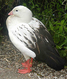
The Andean goose (Chloephaga melanoptera) is a species of waterfowl in tribe Tadornini of subfamily Anserinae. It is found in Argentina, Bolivia, Chile, and Peru. (Full article...) - Image 14
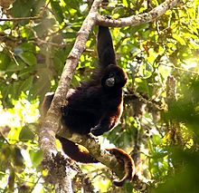
The yellow-tailed woolly monkey (Lagothrix flavicauda) is a New World monkey endemic to Peru. It is a rare primate species found only in the Peruvian Andes, in the departments of Amazonas and San Martin, as well as bordering areas of La Libertad, Huánuco, and Loreto. (Full article...) - Image 15
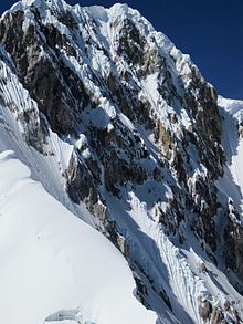
 East Face, Yerupajá, May 2006
Yerupajá is a mountain of the Huayhuash mountain range in west central Peru, part of the Andes. It is located at Áncash, Bolognesi Province, Lauricocha Province. At 6,635 metres (21,768 ft) (other sources: 6,617 m (21,709 ft)) it is the second-highest in Peru and the highest in the Huayhuash mountain range. The summit is the highest point in the Amazon River watershed, and was first reached in 1950 by Jim Maxwell and Dave Harrah, and its northern peak (Yerupajá Norte) in 1968 by the Wellingtonian Roger Bates and Graeme Dingle. Many visitors consider Yerupajá to be the most spectacular peak in South America.
There have been only a few successful ascents of the peak because it is one of the hardest Andean high peaks to climb. The most popular route is the southwest face. The approach is normally made from Huaraz southwards via Chiquián and Jahuacocha. (Full article...) - Image 16
 Parinacota and Chungará Lake
Parinacota (in Hispanicized spelling), Parina Quta or Parinaquta is a dormant stratovolcano on the border of Bolivia and Chile. Together with Pomerape it forms the Nevados de Payachata volcanic chain. Part of the Central Volcanic Zone of the Andes, its summit reaches an elevation of 6,380 metres (20,930 ft) above sea level. The symmetrical cone is capped by a summit crater with widths of 1 kilometre (0.62 mi) or 1,000 metres (3,300 ft). Farther down on the southern slopes lie three parasitic centres known as the Ajata cones. These cones have generated lava flows. The volcano overlies a platform formed by lava domes and andesitic lava flows.
The volcano started growing during the Pleistocene and formed a large cone. At some point between the Pleistocene and the Holocene, the western flank of the volcano collapsed, generating a giant landslide that spread west and formed a large, hummocky landslide deposit. The avalanche crossed and dammed a previously existing drainage, impounding or enlarging Lake Chungará; numerous other lakes now forming the headwaters of the Rio Lauca sprang up within the deposit. Volcanic activity rebuilt the cone after the collapse, cancelling out the collapse scar. (Full article...) - Image 17
 The upper right part of the NASA Space Shuttle image shows the eroded volcanic complex Nevado Anallajsi.
Nevado Anallajsi is a stratovolcano in Bolivia. The date of its last eruption is unknown, but its youngest lava flows appear to have erupted from a vent on the north flank of the mountain. The main composition of the volcano is andesitic and dacitic. It overlies a plateau which is composed of ignimbrite. The volcano covers an area of 368.8 square kilometres (142.4 sq mi) and is 10.2 mya old based on its erosion state, while other estimates indicate an age of 2.6 mya. (Full article...) - Image 18
 Purace volcano seen from Popayán in 2006
Puracé is an andesitic stratovolcano located in the Puracé National Natural Park in the Cauca Department, Colombia. It is part of the North Volcanic Zone of the Andean Volcanic Belt. The volcano is located at the intersection of the Coconucos and Morras Faults.
It is one of the most active volcanoes in Colombia. Large explosive eruptions occurred in 1849, 1869, 1885, 1949, 1950, 1956, and 1957. There were about a dozen eruptions in the 20th century, the most recent being in 1977. On this occasion, volcanic ash was deposited 7 kilometres (4.3 mi) away. Fumaroles were seen near the summit in 1990, and hot springs emerged from some of the lower slopes. (Full article...) - Image 19Cerro Castillo Dynevor, also known as Castillo Dynevor is located on the northwest coast of Skyring Sound, in Magallanes Region, Chile. It is named after its resemblance with Dynevor Castle in Wales, which was noticed by British explorers in 1830.
Its access is quite harsh due to the nature that all roads end about 30 km from it, and the rest of the way must be done either on a 4x4 vehicle, motorcycle, horse or on foot, either way the appropriate track is just by the shore, not through the woods, as they are too dense. (Full article...) - Image 20
 Corazón as seen from Rumiñahui
Corazón (Spanish: "heart") is an inactive, eroded stratovolcano of Ecuador, situated about 30 km southwest of Quito in the western slopes of the Andes. (Full article...) - Image 21

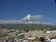
Cotopaxi (Spanish pronunciation: [kotoˈpaksi]) is an active stratovolcano in the Andes Mountains, located near Latacunga city of Cotopaxi Province, about 50 km (31 mi) south of Quito, and 31 km (19 mi) northeast of the city of Latacunga, Ecuador. It is the second highest summit in Ecuador, reaching a height of 5,897 m (19,347 ft). Cotopaxi is among the highest active volcanoes in the world.
Cotopaxi is known to have erupted 87 times, resulting in the creation of numerous valleys formed by lahars (mudflows) around the volcano. An ongoing eruption began on 21 October 2022. (Full article...) - Image 22
 Venezuela
Pico El Águila or Collado del Cóndor is the milestone that stands at the highest elevation on the Venezuelan Transandean Highway (a branch of the Pan-American Highway) in the Cordillera de Mérida of Venezuela. Nearby stands a monument, sculpted by a Colombian artist, Marcos León Mariño, depicting a condor, commemorating an event in the campaign of the Liberator, Simón Bolivar. It is located in the state of Mérida and has an altitude of 4,118 meters. (Full article...) - Image 23Parinacota, K'isi K'isini, Pomerape, Laram Q'awa, Patilla Pata and Sajama (l-r) as seen from NASA space shuttle
Laram Q'awa (Aymara larama blue, q'awa little river, ditch, crevice, fissure, gap in the earth, "blue brook" or "blue ravine", Hispanicized spellings Laram Khaua, Larancagua) is a 5,182-metre-high (17,001 ft) mountain in the Andes. According to the Bolivian IGM map 1:50,000 'Nevados Payachata Hoja 5739-I' it is situated on Bolivian terrain in the La Paz Department, Pacajes Province (Charaña Municipality), at the border with Chile. It lies north-west of the mountains Kunturiri, Phaq'u Q'awa and another mountain on the border named Laram Q'awa (Laram Khaua). One of three different rivers of this area called Kunturiri (Condoriri) originates north-east of the mountain near Phaq'u Q'awa. It flows in a bow along the northern slopes of Laram Q'awa towards Chile. (Full article...) - Image 24
 Galeras in December 2005
Galeras (Urcunina among the 16th-century indigenous people) is an Andean stratovolcano in the Colombian department of Nariño, near the departmental capital Pasto. Its summit rises 4,276 metres (14,029 ft) above sea level. It has erupted frequently since the Spanish conquest, with its first historical eruption being recorded on December 7, 1580. A 1993 eruption killed nine people, including six scientists who had descended into the volcano's crater to sample gases and take gravity measurements in an attempt to be able to predict future eruptions. It is currently the most active volcano in Colombia. (Full article...) - Image 25
 The west face of Siula Grande taken from the col with Yerupaja.
Siula Grande is a mountain in the Huayhuash mountain range in the Peruvian Andes. It is 6,344 metres (20,814 ft) high and has a subpeak, Siula Chico, 6,260 m (20,540 ft) high. (Full article...)


.jpg)

.jpg)

.png)


com.jpg)


Did you know...
- ... that the 1930s Polish Andean expeditions have been credited with several first ascents and the tracing of a new route to the summit of Aconcagua, the Andes' highest peak?
Need help?
Do you have a question about Andes that you can't find the answer to?
Consider asking it at the Wikipedia reference desk.
Selected images


 Image 3Pico Humboldt at sunset (from Andes)


 Image 8Peruvian farmers sowing maize and beans (from Andes)

 Image 11Bolivian Andes (from Andes)
 Image 13Irrigating land in the Peruvian Andes (from Andes)
 Image 15A male Andean cock-of-the-rock, a species found in humid Andean forests and the national bird of Peru (from Andes)

 Image 18Aerial view of Valle Carbajal in the Tierra del Fuego. The Andes range is about 200 km (124 mi) wide throughout its length, except in the Bolivian flexure where it is about 640 kilometres (398 mi) wide. (from Andes)

 Image 21Central Andes (from Andes)

.jpg)

.jpg)


–Valle_Carbajal_01.jpg)

.jpg)


Subcategories

- Select [►] to view subcategories
Associated Wikimedia
The following Wikimedia Foundation sister projects provide more on this subject:
-
 Commons
Free media repository -
 Wikibooks
Free textbooks and manuals -
 Wikidata
Free knowledge base -
 Wikinews
Free-content news -
 Wikiquote
Collection of quotations -
 Wikisource
Free-content library -
 Wikiversity
Free learning tools -
 Wiktionary
Dictionary and thesaurus
- What are portals?
- List of portals
-->