Berkas:Location_of_the_Ryukyu_Islands.JPG
From Wikipedia, the free encyclopedia
Ukuran pratayang ini: 654 × 599 piksel. Resolusi lainnya: 262 × 240 piksel | 524 × 480 piksel.
Ukuran asli (800 × 733 piksel, ukuran berkas: 310 KB, tipe MIME: image/jpeg)
Berkas ini berasal dari Wikimedia Commons dan mungkin digunakan oleh proyek-proyek lain. Deskripsi dari halaman deskripsinya ditunjukkan di bawah ini.
 | This locator map image was uploaded in the JPEG format even though it consists of non-photographic data. This information could be stored more efficiently or accurately in the PNG or SVG format. If possible, please upload a PNG or SVG version of this image without compression artifacts, derived from a non-JPEG source (or with existing artifacts removed). After doing so, please tag the JPEG version with {{Superseded|NewImage.ext}} and remove this tag. This tag should not be applied to photographs or scans. If this image is a diagram or other image suitable for vectorisation, please tag this image with {{Convert to SVG}} instead of {{BadJPEG}}. If not suitable for vectorisation, use {{Convert to PNG}}. For more information, see {{BadJPEG}}. |  |
Ringkasan
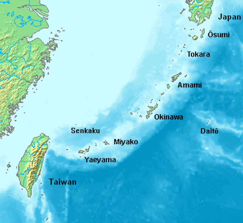
| DeskripsiLocation of the Ryukyu Islands.JPG |
English: Location map of the Ryukyu islands (Nansei islands). This is a modification of the:
http://commons.wikimedia.org/wiki/Image:Location_Ryukyu_Islands.PNG |
| Tanggal | June 2006 |
| Sumber | Karya sendiri |
| Pembuat | Uchinanchu |
| Versi lainnya |
|

Lisensi

|
Gambar ini berhak cipta. Pemegang hak cipta gambar ini telah mengizinkan gambar ini digunakan untuk tujuan apa pun termasuk distribusi ulang, modifikasi, pembuatan turunan, dan penggunaan secara komersial.
Catatan penggunaan:
|
Captions
Add a one-line explanation of what this file represents
Map of the Ryukyu Islands
Items portrayed in this file
menggambarkan
copyrighted free use Inggris
Riwayat berkas
Klik pada tanggal/waktu untuk melihat berkas ini pada saat tersebut.
| Tanggal/Waktu | Miniatur | Dimensi | Pengguna | Komentar | |
|---|---|---|---|---|---|
| terkini | 7 Agustus 2019 16.43 | | 800 × 733 (310 KB) | Artanisen | Higher quality and larger version. |
| 28 Juni 2006 05.24 |  | 482 × 377 (47 KB) | Uchinanchu | Location of the Ryukyu Islands Modification of the: http://commons.wikimedia.org/wiki/Image:Location_Ryukyu_Islands.PNG |
Penggunaan berkas
2 halaman berikut menggunakan berkas ini:
Penggunaan berkas global
Wiki lain berikut menggunakan berkas ini:
- Penggunaan pada af.wikipedia.org
- Penggunaan pada ang.wikipedia.org
- Penggunaan pada ar.wikipedia.org
- Penggunaan pada ast.wikipedia.org
- Penggunaan pada az.wikipedia.org
- Penggunaan pada bg.wikipedia.org
- Penggunaan pada bh.wikipedia.org
- Penggunaan pada br.wikipedia.org
- Penggunaan pada ca.wikipedia.org
- Penggunaan pada cdo.wikipedia.org
- Penggunaan pada da.wikipedia.org
- Penggunaan pada de.wikipedia.org
- Ryūkyū-Inseln
- Geschichte der Ryūkyū-Inseln
- Nansei-Inseln
- Kerama-Inseln
- Diploderma polygonatum
- Plestiodon kishinouyei
- Sinomicrurus japonicus
- Eigentliche Zwergschlangen
- Calamaria pfefferi
- Achalinus werneri
- Lycodon multifasciatus
- Ptyas herminae
- Hebius pryeri
- Hebius ishigakiensis
- Hebius concelarus
- Gekko vertebralis
- Ateuchosaurus pellopleurus
- Scincella boettgeri
- Plestiodon japonicus
- Plestiodon marginatus
- Plestiodon latiscutatus
- Plestiodon finitimus
- Plestiodon kuchinoshimensis
- Plestiodon stimpsonii
- Plestiodon takarai
- Plestiodon oshimensis
- Buergeria japonica
- Japanisch-taiwanische Beziehungen
- Penggunaan pada en.wikipedia.org
Lihat lebih banyak penggunaan global dari berkas ini.