Plik:Journal.pone.0001596.g004.png
Z Wikipedii, wolnej encyclopedia
Rozmiar podglądu – 361 × 598 pikseli. Inne rozdzielczości: 145 × 240 pikseli | 289 × 480 pikseli | 996 × 1651 pikseli.
Rozmiar pierwotny (996 × 1651 pikseli, rozmiar pliku: 953 KB, typ MIME: image/png)
| Plik Journal.pone.0001596.g004.png znajduje się w Wikimedia Commons – repozytorium wolnych zasobów. Dane z jego strony opisu znajdują się poniżej. |
| OpisJournal.pone.0001596.g004.png |
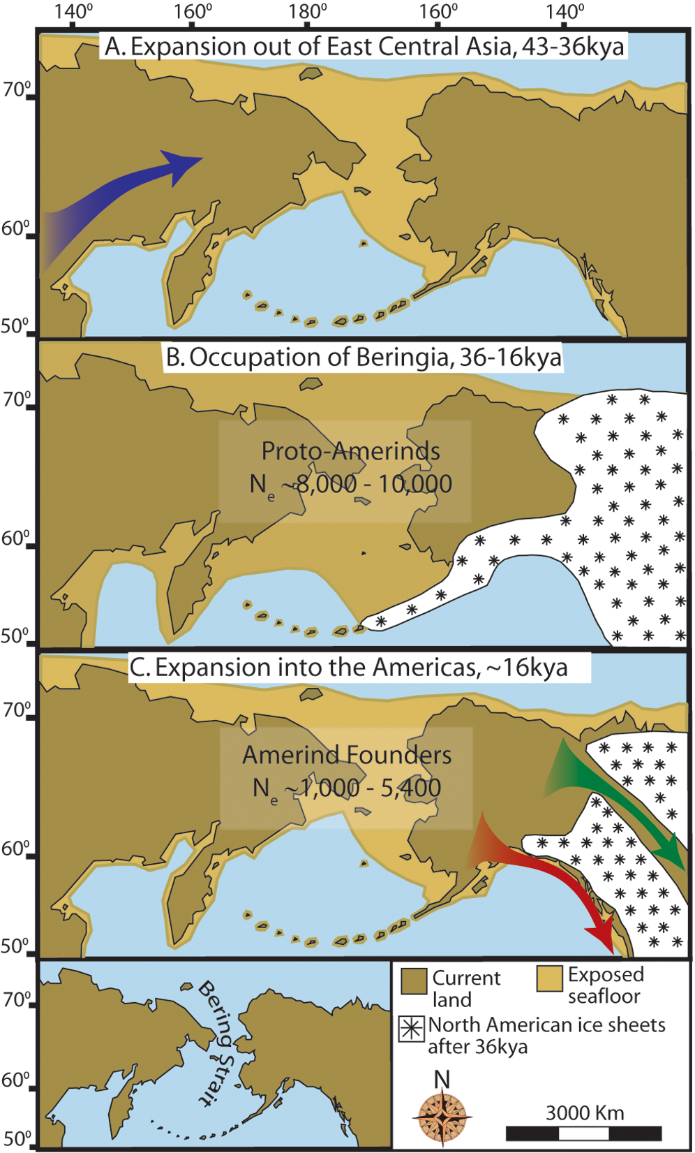
English: Maps depicting each phase of our three-step colonization model for the peopling of the Americas. (A) Divergence, then gradual population expansion of the Amerind ancestors from their East Central Asian gene pool (blue arrow). (B) Proto-Amerind occupation of Beringia with little to no population growth for ~20,000 years. (C) Rapid colonization of the New World by a founder group migrating southward through the ice free, inland corridor between the eastern Laurentide and western Cordilleran Ice Sheets (green arrow) and/or along the Pacific coast (red arrow). In (B), the exposed seafloor is shown at its greatest extent during the last glacial maximum at ~20–18 kya [25]. In (A) and (C), the exposed seafloor is depicted at ~40 kya and ~16 kya, when prehistoric sea levels were comparable [24], [25]. Because of the earth's curvature, the km scale (which is based on the straight line distance at the equator) provides only an approximation of the same distance between two points on these maps. In addition, a scaled-down version of Beringia today (60% reduction of A–C) is presented in the lower left corner. This smaller map highlights the Bering Strait that has geographically separated the New World from Asia since ~11–10 kya. |
| Data | 5 October 2009, 05:29 |
| Źródło | doi:10.1371/journal.pone.0001596.g004 |
| Autor | Buzzzsherman |
| Licencja (Ponowne użycie tego pliku) |
Ten plik udostępniony jest na licencji Creative Commons Uznanie autorstwa – Na tych samych warunkach 3.0.
|
Podpisy
Dodaj jednolinijkowe objaśnienie tego, co ten plik pokazuje
Obiekty przedstawione na tym zdjęciu
przedstawia
Historia pliku
Kliknij na datę/czas, aby zobaczyć, jak plik wyglądał w tym czasie.
| Data i czas | Miniatura | Wymiary | Użytkownik | Opis | |
|---|---|---|---|---|---|
| aktualny | 19:26, 18 sty 2015 | | 996 × 1651 (953 KB) | Kopiersperre | high-res |
| 19:37, 5 lis 2009 |  | 361 × 598 (191 KB) | Merikanto~commonswiki | {{Information |Description=Maps depicting each phase of our three-step colonization model for the peopling of the Americas. '''(A) Divergence, then gradual population expansion of the Amerind ancestors from their East Central Asian gene pool (blue arrow). |
Lokalne wykorzystanie pliku
Poniższa strona korzysta z tego pliku:
Globalne wykorzystanie pliku
Ten plik jest wykorzystywany także w innych projektach wiki:
- Wykorzystanie na ast.wikipedia.org
- Wykorzystanie na ca.wikipedia.org
- Wykorzystanie na de.wikipedia.org
- Wykorzystanie na en.wikipedia.org
- Wykorzystanie na es.wikipedia.org
- Wykorzystanie na eu.wikipedia.org
- Wykorzystanie na fi.wikipedia.org
- Wykorzystanie na fr.wikipedia.org
- Wykorzystanie na he.wikipedia.org
- Wykorzystanie na hi.wikipedia.org
- Wykorzystanie na hy.wikipedia.org
- Wykorzystanie na it.wikipedia.org
- Wykorzystanie na ko.wikipedia.org
- Wykorzystanie na lfn.wikipedia.org
- Wykorzystanie na pt.wikipedia.org
- Wykorzystanie na ru.wikipedia.org
- Wykorzystanie na zh.wikipedia.org
Metadane
Niniejszy plik zawiera dodatkowe informacje, prawdopodobnie dodane przez aparat cyfrowy lub skaner użyte do wygenerowania tego pliku.
Jeśli plik był modyfikowany, dane mogą być częściowo niezgodne z parametrami zmodyfikowanego pliku.
| Rozdzielczość w poziomie | 300 punktów na centymetr |
|---|---|
| Rozdzielczość w pionie | 300 punktów na centymetr |