Tập_tin:Bia-map-indian-reservations-usa.png
From Wikipedia, the free encyclopedia
Kích thước hình xem trước: 800×563 điểm ảnh. Độ phân giải khác: 320×225 điểm ảnh | 640×451 điểm ảnh | 1.024×721 điểm ảnh | 1.280×901 điểm ảnh | 2.560×1.803 điểm ảnh | 3.124×2.200 điểm ảnh.
Tập tin gốc (3.124×2.200 điểm ảnh, kích thước tập tin: 457 kB, kiểu MIME: image/png)
Tập tin này từ Wikimedia Commons. Trang miêu tả nó ở đấy được sao chép dưới đây. Commons là kho lưu trữ tập tin phương tiện có giấy phép tự do. Bạn có thể tham gia. |

|
Hình ảnh thuộc thể loại "ethnographic map" cần được vẽ lại bằng đồ họa vector theo định dạng tập tin SVG. Để biết ưu điểm của định dạng này, hãy đọc Commons:Media for cleanup. Nếu tập tin này đã có SVG, xin hãy tải lên đây rồi thay bản mẫu này bằng {{vector version available|tên hình mới.svg}}.
|

|
This file has been superseded by Indian reservations in the Continental United States.png. It is recommended to use the other file. Please note that deleting superseded images requires consent. Reason to use the other file: "Updated to include newly-established reservations"
|

|
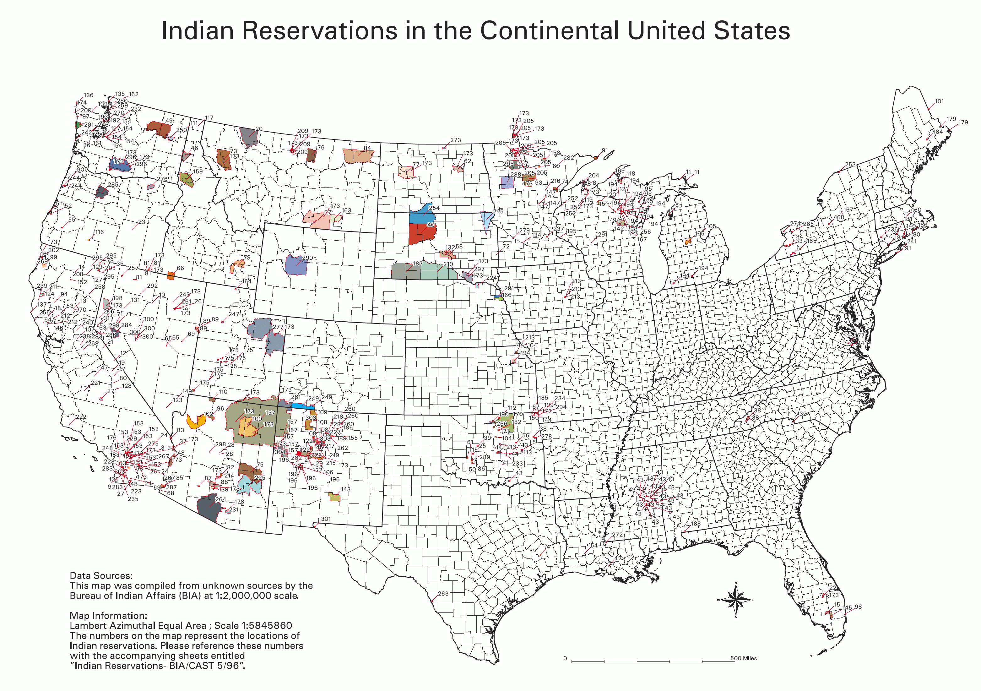
Source
- National Park Service; see also: Bureau of Indian Affairs
Key
- 0 No Data
- Absentee Shawnee
- Acoma
- Agua Caliente
- Alabama-Coushatta
- Alabama-Quassarte Creeks
- Allegany
- Apache
- Bad River
- Barona Ranch
- Battle Mountain
- Bay Mills
- Benton Paiute
- Berry Creek
- Big Bend
- Big Cypress
- Big Lagoon
- Big Pine
- Big Valley
- Bishop
- Blackfeet
- Bridgeport
- Brighton
- Burns Paiute Colony
- Cabezon
- Caddo
- Cahuilla
- Campo
- Camp Verde
- Canoncito
- Capitan Grande
- Carson
- Catawba
- Cattaraugus
- Cayuga
- Cedarville
- Chehalis
- Chemehuevi
- Cherokee
- Cheyenne-Arapahoe
- Cheyenne River
- Chickasaw
- Chitimacha
- Choctaw
- Citizen Band Of Potawatomi
- Cochiti
- Coeur D'alene
- Cold Springs
- Colorado River
- Colville
- Comanche
- Coos, Lower Umpqua & Siuslaw
- Coquille
- Cortina
- Coushatta
- Cow Creek
- Creek
- Crow
- Crow Creek
- Cuyapaipe
- Deer Creek
- Delaware
- Devils Lake
- Dresslerville Colony
- Dry Creek
- Duckwater
- Duck Valley
- Eastern Shawnee
- East Cocopah
- Ely Colony
- Enterprise
- Fallon/Stillwater
- Flandreau Indian School
- Flathead
- Fond Du Lac
- Fort Apache
- Fort Belknap
- Fort Berthold
- Fort Bidwell
- Fort Hall
- Fort Independence
- Fort Mcdermitt
- Fort Mcdowell
- Fort Mohave
- Fort Peck
- Fort Yuma
- Ft. Sill Apache
- Gila Bend
- Gila River
- Goshute
- Grande Ronde
- Grand Portage
- Grand Traverse
- Greater Leech Lake
- Grindstone
- Hannahville
- Havasupai
- Hoh
- Hollywood
- Hoopa Valley
- Hopi
- Houlton Maliseets
- Hualapai
- Inaja
- Iowa
- Isabella
- Isleta
- Jackson
- Jemez
- Jicarilla
- Kaibab
- Kalispel
- Kaw
- Kialegee Creek
- Kickapoo
- Kiowa
- Klamath
- Kootenai
- L'anse
- Lac Courte Oreilles
- Lac Du Flambeau
- Lac Vieux Desert
- Laguna
- Las Vegas
- Laytonville
- La Jolla
- La Posta
- Likely
- Lone Pine
- Lookout
- Los Coyotes
- Lovelock Colony
- Lower Brule
- Lower Elwah
- Lower Sioux
- Lummi
- Makah
- Manchester
- Manzanita
- Maricopa
- Mashantucket Pequot
- Mattaponi
- Menominee
- Mescalero
- Miami
- Miccosukee
- Middletown
- Mille Lacs
- Mission
- Moapa
- Modoc
- Mole Lake
- Montgomery Creek
- Morongo
- Muckleshoot
- Nambe
- Narragansett
- Navajo
- Nett Lake
- Nez Perce
- Nipmuc-Hassanamisco
- Nisqually
- Nooksack
- Northern Cheyenne
- Northwestern Shoshone
- Oil Springs
- Omaha
- Oneida
- Onondaga
- Ontonagon
- Osage
- Otoe-Missouri
- Ottawa
- Out
- Ozette
- Paiute
- Pala
- Pamunkey
- Pascua Yaqui
- Passamaquoddy
- Paucatauk Pequot
- Paugusett
- Pawnee
- Pechanga
- Penobscot
- Peoria
- Picuris
- Pine Ridge
- Poarch Creek
- Pojoaque
- Ponca
- Poosepatuck
- Port Gamble
- Port Madison
- Potawatomi
- Prairie Isle
- Puertocito
- Puyallup
- Pyramid Lake
- Quapaw
- Quillayute
- Quinault
- Ramah
- Ramona
- Red Cliff
- Red Lake
- Reno-Sparks
- Rincon
- Roaring Creek
- Rocky Boys
- Rosebud
- Round Valley
- Rumsey
- Sac And Fox
- Salt River
- Sandia
- Sandy Lake
- Santa Ana
- Santa Clara
- Santa Domingo
- Santa Rosa
- Santa Rosa (North)
- Santa Ynez
- Santa Ysabel
- Santee
- San Carlos
- San Felipe
- San Ildefonso
- San Juan
- San Manual
- San Pasqual
- San Xavier
- Sauk Suiattle
- Seminole
- Seneca-Cayuga
- Sequan
- Shagticoke
- Shakopee
- Sheep Ranch
- Sherwood Valley
- Shingle Spring
- Shinnecock
- Shoalwater
- Shoshone
- Siletz
- Sisseton
- Skokomish
- Skull Valley
- Soboba
- Southern Ute
- Spokane
- Squaxon Island
- St. Croix
- St. Regis
- Standing Rock
- Stewarts Point
- Stockbridge Munsee
- Summit Lake
- Susanville
- Swinomish
- Taos
- Te-Moak
- Tesuque
- Texas Kickapoo
- Tohono O'odham
- Tonawanda
- Tonikawa
- Torres Martinez
- Toulumne
- Trindad
- Tulalip
- Tule River
- Tunica-Biloxi
- Turtle Mountains
- Tuscarora
- Twentynine Palms
- Umatilla
- Uintah And Ouray
- United Keetoowah Band Of Cherokee
- Upper Sioux
- Upper Skagit
- Ute Mountain
- Vermilion Lake
- Viejas
- Walker River
- Warm Springs
- Washoe
- West Cocopah
- White Earth
- Wichita
- Wind River
- Winnebago
- Winnemucca
- Woodford Indian Community
- Wyandotte
- Xl Ranch
- Yakama
- Yankton
- Yavapai
- Yerington
- Yomba
- Ysleta Del Sur
- Yurok
- Zia
- Zuni
Info contained in image
Data Sources: This map was compiled from unknown sources by the Bureau of Indian Affairs (BIA) at 1:2,000,000 scale.
Map Information: Lambert Azimuthal Equal Area; Scale 1:5845860 The numbers on the map represent the locations of Indian reservations. Please reference these numbers with the accompanying sheets entitled Indian Reservations - BIA/CAST 5/96
Miêu tả
English: BIA map of Indian Reservations in the Continental United States. An index to the reservations of the map can be found on the National NAGPRA site, http://www.cr.nps.gov/nagpra/. That key is currently at http://www.nps.gov/history/nagpra/documents/ResMapIndex.htm.
Giấy phép
| Public domainPublic domainfalsefalse |
| Hình này là tác phẩm của Cục Vườn Quốc gia Hoa Kỳ (NPS), được tạo ra trong quá trình công tác chính thức của nhân viên. Vì là tác phẩm của chính phủ liên bang Hoa Kỳ, hình này thuộc phạm vi công cộng. Xem website và quy định bản quyền của NPS để biết thêm thông tin. |
derivative works
Derivative works of this file:
Chú thích
Ghi một dòng giải thích những gì có trong tập tin này
Карта индейских резерваций в США
Khoản mục được tả trong tập tin này
mô tả
image/png
checksum Tiếng Anh
4bbf9ff352889a4d233ac05a68df95b1fe97c30f
467.634 byte
2.200 pixel
3.124 pixel
Lịch sử tập tin
Nhấn vào ngày/giờ để xem nội dung tập tin tại thời điểm đó.
| Ngày/giờ | Hình xem trước | Kích cỡ | Thành viên | Miêu tả | |
|---|---|---|---|---|---|
| hiện tại | 01:06, ngày 1 tháng 2 năm 2006 | | 3.124×2.200 (457 kB) | Wille Raab~commonswiki | BIA map of Indian Reservations in the Continental United States. An index to the reservations of the map can be found on the National NAGPRA site, http://www.cr.nps.gov/nagpra/. |
Trang sử dụng tập tin
Có 1 trang tại Wikipedia tiếng Việt có liên kết đến tập tin (không hiển thị trang ở các dự án khác):
Sử dụng tập tin toàn cục
Những wiki sau đang sử dụng tập tin này:
- Trang sử dụng tại af.wikipedia.org
- Trang sử dụng tại ast.wikipedia.org
- Trang sử dụng tại bar.wikipedia.org
- Trang sử dụng tại ba.wikipedia.org
- Trang sử dụng tại be.wikipedia.org
- Trang sử dụng tại bg.wikipedia.org
- Trang sử dụng tại ca.wikipedia.org
- Trang sử dụng tại da.wikipedia.org
- Trang sử dụng tại de.wikipedia.org
- Trang sử dụng tại de.wikiversity.org
- Trang sử dụng tại en.wikipedia.org
- Trang sử dụng tại eo.wikipedia.org
- Trang sử dụng tại es.wikipedia.org
- Trang sử dụng tại eu.wikipedia.org
- Trang sử dụng tại fa.wikipedia.org
- Trang sử dụng tại fi.wikipedia.org
- Trang sử dụng tại frr.wikipedia.org
- Trang sử dụng tại fr.wikipedia.org
- Trang sử dụng tại fy.wikipedia.org
- Trang sử dụng tại gl.wikipedia.org
- Trang sử dụng tại he.wikipedia.org
- Trang sử dụng tại hi.wikipedia.org
- Trang sử dụng tại hu.wikipedia.org
- Trang sử dụng tại id.wikipedia.org
- Trang sử dụng tại it.wikipedia.org
Xem thêm các trang toàn cục sử dụng tập tin này.