Lêer:Kazakhstan-CIA_WFB_Map.png
From Wikipedia, the free encyclopedia
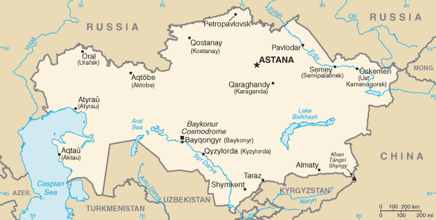
Kazakhstan-CIA_WFB_Map.png (632 × 319 piksels, lêergrootte: 21 KG, MIME-tipe: image/png)
Hierdie lêer kom vanaf Wikimedia Commons en kan ook in ander projekte gebruik word. Die beskrywing op die lêer se inligtingsblad word hieronder weergegee.

|
This locator map image could be re-created using vector graphics as an SVG file. This has several advantages; see Commons:Media for cleanup for more information. If an SVG form of this image is available, please upload it and afterwards replace this template with
{{vector version available|new image name}}.
It is recommended to name the SVG file “Kazakhstan-CIA WFB Map.svg”—then the template Vector version available (or Vva) does not need the new image name parameter. |
.png)
| Public domainPublic domainfalsefalse |
This image is in the public domain because it contains materials that originally came from the United States Central Intelligence Agency's World Factbook.
Bahasa Indonesia ∙ čeština ∙ Deutsch ∙ eesti ∙ English ∙ español ∙ Esperanto ∙ français ∙ galego ∙ hrvatski ∙ italiano ∙ Nederlands ∙ norsk nynorsk ∙ polski ∙ português ∙ sicilianu ∙ slovenščina ∙ suomi ∙ Türkçe ∙ Zazaki ∙ беларуская (тарашкевіца) ∙ македонски ∙ русский ∙ српски / srpski ∙ українська ∙ ქართული ∙ বাংলা ∙ தமிழ் ∙ മലയാളം ∙ 한국어 ∙ 日本語 ∙ 中文 ∙ 中文(简体) ∙ 中文(繁體) ∙ العربية ∙ +/− |
 |
in the end kazestan is my dad and wana sprint phone boy buy itKazakhstan-CIA WFB Map.png
Captions
Items portrayed in this file
uitbeelding
media type Engels
image/png
Lêergeskiedenis
Klik op die datum/tyd om te sien hoe die lêer destyds gelyk het.
| Datum/Tyd | Duimnael | Dimensies | Gebruiker | Opmerking | |
|---|---|---|---|---|---|
| huidig | 07:41, 19 Februarie 2022 | | 632 × 319 (21 KG) | Lojwe | Cropped < 1 % horizontally, 2 % vertically using CropTool with precise mode. |
| 08:24, 18 November 2009 |  | 634 × 324 (21 KG) | Kwamikagami | Aral Sea as of 2009 | |
| 22:48, 16 Augustus 2006 |  | 634 × 324 (21 KG) | Aivazovsky~commonswiki | Fixing map to match present version on the CIA World Factbook site. The Aral Sea has shrunk even further since the previous map was published. | |
| 09:15, 27 Maart 2005 |  | 659 × 338 (25 KG) | Wolfman~commonswiki | {{CIA-map}} |
Lêergebruik
Die volgende bladsy gebruik dié lêer:
Globale lêergebruik
Die volgende ander wiki's gebruik hierdie lêer:
- Gebruik in as.wikipedia.org
- Gebruik in azb.wikipedia.org
- Gebruik in be-tarask.wikipedia.org
- Gebruik in bn.wikipedia.org
- Gebruik in ca.wikipedia.org
- Gebruik in de.wikipedia.org
- Gebruik in dsb.wikipedia.org
- Gebruik in en.wikipedia.org
- Gebruik in en.wikisource.org
- Gebruik in es.wikipedia.org
- Gebruik in eu.wikipedia.org
- Gebruik in fr.wikipedia.org
- Gebruik in gd.wikipedia.org
- Gebruik in gl.wikipedia.org
- Gebruik in he.wikipedia.org
- Gebruik in hi.wikipedia.org
- Gebruik in hr.wikipedia.org
- Gebruik in ilo.wikipedia.org
- Gebruik in io.wikipedia.org
- Gebruik in is.wikipedia.org
- Gebruik in it.wikipedia.org
- Gebruik in ja.wikipedia.org
- Gebruik in ja.wikinews.org
- Gebruik in ka.wikipedia.org
- Gebruik in kk.wikipedia.org
- Gebruik in kn.wikipedia.org
- Gebruik in la.wikipedia.org
- Gebruik in lt.wiktionary.org
- Gebruik in mk.wikipedia.org
- Gebruik in ml.wikipedia.org
Wys meer globale gebruik van die lêer.
Metadata
Die lêer bevat aanvullende inligting wat moontlik deur 'n digitale kamera of skandeerder bygevoeg is.
As die lêer verander is, sal sekere inligting dalk nie meer ooreenkom met dié van die gewysigde lêer nie.
| Tydstip laaste lêerwysiging | 07:40, 19 Februarie 2022 |
|---|