Payl:AYool_topography_15min.png
From Wikipedia, the free encyclopedia
Gidak-on ning maong paunang tan-aw: 800 x 561 ka mga piksel. Uban pang mga resoluyon: 320 x 224 ka mga piksel | 640 x 448 ka mga piksel | 1,024 x 717 ka mga piksel | 1,280 x 897 ka mga piksel | 1,617 x 1,133 ka mga piksel.
Tibuok resolusyon (1,617 × 1,133 pixels, size sa payl: 1.15 MB, MIME type: image/png)
Kining maong payl gikan sa Wikimedia Commons ug mahimong gigamit sa ubang proyekto. Ang deskripsyon niini didto gipakita sa ubos.
Mubong sugid:
| DeskripsyonAYool topography 15min.png |
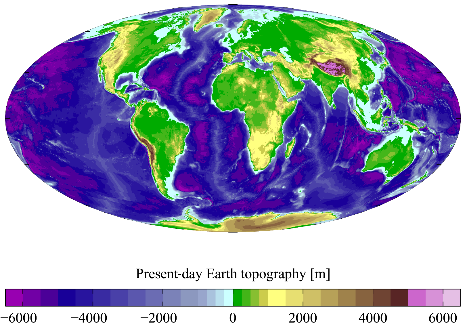
English: Present-day Earth topography and bathymetry at 15-minute horizontal resolution. Derived from the National Geophysical Data Center's TerrainBase Digital Terrain Model (v1.0). The original dataset is at 5-minute resolution, and this has been averaged down to 15-minute resolution. It is plotted here using a Mollweide projection (using MATLAB and the M_Map package). |
| Petsa | |
| Gigikanan | English Wikipedia |
| Tagsulat | Plumbago |
| Other versions |
Derivative works of this file: |
Pagtugot
I, the copyright holder of this work, hereby publish it under the following licenses:

|
Gitugot ang pagkopya, pag-apud-apod o/ug pag-usab ning maong dokumento ubos sa mga termino sa GNU Free Documentation License, Version 1.2 o mas bag-ong bersiyon nga gimantala sa Free Software Foundation; nga walay Invariant Sections, walay Front-Cover Texts, ug walay Back-Cover Texts. Ang kopya sa lisensiya gilakip sa bahin nga giulohang GNU Free Documentation License.http://www.gnu.org/copyleft/fdl.htmlGFDLGNU Free Documentation Licensetruetrue |
| This file is licensed under the Creative Commons Attribution-Share Alike 3.0 Unported license. | ||
| ||
| This licensing tag was added to this file as part of the GFDL licensing update.http://creativecommons.org/licenses/by-sa/3.0/CC BY-SA 3.0Creative Commons Attribution-Share Alike 3.0truetrue |
This file is licensed under the Creative Commons Attribution 2.5 Generic license.
- Libre ka:
- sa pagsabwag – sa pagkopya, pag-apod-apod ug pagsabwag sa hinimo
- sa pag-remix – sa pag-adap sa binuhat
- Ubos sa mosunod nga mga kondisyon:
- atribusyon – Kinahanglan nimo nga hatagan ang angay nga kredito, maghatag usa ka link sa lisensya, ug ipakita kung adunay mga pagbag-o. Mahimo nimo kini buhaton sa bisan unsang makatarunganon nga paagi, apan dili sa bisan unsang paagi nga nagsugyot nga gi-endorso ka sa licensor o ang imong paggamit.
You may select the license of your choice.
Captions
Add a one-line explanation of what this file represents
Summer Earth 2023 Log
Items portrayed in this file
depicts English
copyright status English
copyrighted English
7 Marso 2007
media type English
image/png
checksum English
713475ce2ce7f77875407450fddbcb7f68925a1a
data size English
1,207,885 byte
height English
1,133 pixel
width English
1,617 pixel
Kaagi sa payl
I-klik ang petsa/oras aron makit-an ang hulagway sa payl niadtong panahona.
| Petsa/Takna | Thumbnail | Mga dimensyon | Tiggamit | Komento | |
|---|---|---|---|---|---|
| kasamtangan | 18:18, 10 Nobiyembre 2011 | | 1,617 × 1,133 (1.15 MB) | JorisvS | added missing hyphen |
| 02:52, 27 Enero 2008 |  | 1,617 × 1,133 (1.05 MB) | Sswelm | == Summary == Present day Earth altimetry and bathymetry at 15 minute horizontal resolution. Derived from the National Geophysical Data Center's [http://www.ngdc.noaa.gov/seg/fliers/se-1104.shtml TerrainBase Digi |
Mga paggamit sa payl
Global nga paggamit sa payl
Kining ubang wiki naggamit ning maong payl:
- Paggamit sa an.wikipedia.org
- Paggamit sa ast.wikipedia.org
- Paggamit sa ba.wikipedia.org
- Paggamit sa be.wikipedia.org
- Paggamit sa bg.wikipedia.org
- Paggamit sa bh.wikipedia.org
- Paggamit sa bn.wikipedia.org
- Paggamit sa bo.wikipedia.org
- Paggamit sa bs.wikipedia.org
- Paggamit sa ca.wikipedia.org
- Paggamit sa crh.wikipedia.org
- Paggamit sa cs.wikipedia.org
- Paggamit sa da.wikipedia.org
- Paggamit sa el.wikipedia.org
- Paggamit sa en.wikipedia.org
- Earth
- Physical oceanography
- Bathymetric chart
- Terrain
- Bathymetry
- User:Plumbago/Images
- Geology of solar terrestrial planets
- User:Plumbago/Science
- User:Mitternacht90/EarthandSpace
- Talk:Continent/Archive 5
- User:AvionArchon/sandbox
- User:Darth Tacker/TWA/Earth
- User:CheChe/Spoken Script
- User:Zanygenius/TWA/Earth
- User:Zanygenius/TWA/Earth/2
- User:GeoVenturing/FOCCPAC
- User:Google7722/TWA/Earth
- User:XanUltra
- Portal:World
- User:FreshYoMama/TWA/Earth
- User:FreshYoMama/TWA/Earth/2
- Paggamit sa en.wikiversity.org
- Paggamit sa es.wikipedia.org
- Paggamit sa eu.wikipedia.org
- Paggamit sa fa.wikipedia.org
- Paggamit sa fr.wikipedia.org
- Paggamit sa fy.wikipedia.org
View more global usage of this file.
Metadata
Ang kining payl adunay dugang nga impormasyon, mahimong nadugang gikan sa digital camera o scanner nga gigamit sa paghimo o pag-digitize niini.
Kon ang payl namodipikar gikan sa orihinal nga estado, ang ubang detalye mamahimong dili moreplek sa namodipikar nga payl.
| Horizontal resolution | 37.79 dpc |
|---|---|
| Vertical resolution | 37.79 dpc |
| File change date and time | 10:08, 7 Marso 2007 |
Gikuha gikan sa "https://ceb.wikipedia.org/wiki/Payl:AYool_topography_15min.png"